East Fishkill Master Plan - May 2002
Courtesy of

www.dutchess29.org
May 10, 2002
- To view a chart or figure, click on its
 button;
then use your browser BACK button to return to the text.
- To save an image on your computer, right-click on the image
and select SAVE IMAGE AS. Then choose a folder, and select SAVE.
- Footnotes are shown as numbers in parens. Example: (1)
- Photographs not shown.
- Figures not shown are still noted.
- PUBLIC HEARING DATE: Go to www.dutchess29.org.


BEGIN MASTER PLAN
COMPREHENSIVE PLAN
Town of East Fishkill, NY
May 2002
Buckhurst Fish & Jacquemart, Inc.
DRAFT
Comprehensive Plan
Town of East Fishkill
Town of East Fishkill
Town Board and Master Plan Steering Committee
May 2002
Buckhurst Fish and Jacquemart Inc.
______________________________________________________________________________________________________
PAGE i
Acknowledgements
Town Board
Peter Idema, Supervisor
Ethel Walker, Deputy Supervisor
Richard Ferland
Donald Way
Peter Cassidy
Master Plan Steering Committee
Sandy Tambone
Edmund Newhard
Michael Donnelly
Beverly Ferland
Paul Pesavento
GIS Coordinator
Jennifer Cox
______________________________________________________________________________________________________
PAGE ii
Dedication
to
Beverly Ferland
This Master Plan is dedicated to the
memory of Beverly Ferland,
long-time resident of East Fishkill
and Planning Board Secretary.
As the Town moves forward with a
new Comprehensive Plan, we remember
with fondness her participation and
involvement with our community.
______________________________________________________________________________________________________
PAGE iii
Table of Contents
EXECUTIVE SUMMARY viii
1.0 INTRODUCTION 1
1.1 Purpose of the Plan 1
1.2 Master Plan Process 1
1.3 Organization of the Master Plan 3
2.0 HISTORICAL AND REGIONAL CONTEXT 4
2.1 History 4
2.2 Regional Context and Development Patterns 6
2.3 Regional and County Plans 8
3.0 POPULATION 12
3.1 Growth 12
3.2 Households 14
3.3 Race and Ethnicity 14
3.4 Homes 15
3.5 Income and Education 16
3.6 Place of Work 16
3.7 Conclusions 17
4.0 LAND USE 19
4.1 Land Use and Zoning 19
4.2 Development Potential 24
______________________________________________________________________________________________________
PAGE iv
5.0 ENVIRONMENT 28
5.1 Slopes 28
5.2 Surface Water, Wetlands, and Floodplains 28
5.3 Soils 31
5.4 Groundwater Resources 32
5.5 Environmental Summary 35
6.0 TRANSPORTATION 36
6.1 Introduction 36
6.2 Existing Roadway System and Traffic Volumes 36
6.3 Park and Ride Lots 40
6.4 Safety and Circulation Issues 41
6.5 Safety Improvements 44
6.6 New Roadway Segments and Roadway Improvements 46
6.7 Functional Classification of Future Roadway System 49
6.8 Public Transportation 51
6.9 Pedestrian Policy 55
6.10 Bicycle Policy 56
7.0 COMMUNITY SERVICES 58
7.1 Town Government 58
7.2 Library 58
7.3 Police Protection 60
7.4 Fire Protection 61
7.5 School Facilities 62
7.6 Recreation 64
7.7 Cultural Resources 70
7.8 Water and Sewer Districts 72
______________________________________________________________________________________________________
PAGE v
8.0 MASTER PLAN 79
8.1 Findings and Goals 79
8.2 Future Land Use Plan 84
8.3 Elements of the Plan 87
8.4 Design 90
8.5 Conclusion 100
9.0 IMPLEMENTATION 102
9.1 Official Town Map 102
9.2 Zoning/Subdivision Regulations 102
9.3 Natural Resource Protection 104
9.4 Capital Improvements Program / Land Transaction 107
9.5 Real Estate Tax Inducements 108
9.6 Private Development and Philanthropy 109
List of Figures
Figure 1.1 Workshop Photos 2
Figure 2.1 Historic Map 5
Figure 2.2 Location Map 7
Figure 2.3 Regional Plan Association Map 10
Figure 2.4 Directions 11
Figure 3.1 Population Pyramid 13
Figure 3.2 Commuter Map 18
Figure 4.1 Existing Land Use 21
Figure 4.2 Zoning Map 23
Figure 4.3 Developable Land 26
Figure 5.1 Slopes 29
Figure 5.2 Water Resources 30
Figure 5.3 Soils 33
Figure 5.4 Aquifer 34
Figure 6.1 Traffic Volumes 38
Figure 6.2 Accident Locations 42
Figure 6.3 Hopewell Hamlet and Vicinity New Roads 48
______________________________________________________________________________________________________
PAGE vi
Figure 6.4 Future Roadway Classification 50
Figure 6.5 Bus Map 52
Figure 6.6 Regional Rail Map 53
Figure 6.7 Local Rail Map 54
Figure 6.8 Bicycle Plan 57
Figure 7.1 Public Facilities Map 59
Figure 7.2 School Facilities and Districts 63
Figure 7.3 Recreation Facilities 65
Figure 7.4 Historic Map 71
Figure 7.5 Water Systems 73
Figure 7.6 Central Water Systems and Phases 74
Figure 7.7 Dutchess County Central Utility Corridor Water Line 75
Figure 7.8 Existing Sewer Systems 78
Figure 8.1 Future Land Use Map 85
Figure 8.2 Active Farm Overlay 86
Figure 8.3 Traditional Development Drawing 92
Figure 8.4 Cluster Development Drawing 93
Figure 8.5 Cluster Subdivision Principles 94
Figure 8.6 Hopewell Junction Existing Conditions Route 82 97
Figure 8.7 Hopewell Junction Photographs 98
Figure 8.8 Hopewell Junction Proposed Improvements Route 82 99
Figure 9.1 Floor Area Ratio 105
List of Tables
Table 3.1 Population Figures 12
Table 3.2 Number of Residential Building Permits Issued for 15
New Homes, 1991-2001
Table 3.3 Residential Sales Statistics, Jul-Dec, 2001 16
Table 4.1 Existing Land Uses, 1981-2002 20
Table 4.2 Zoning Acreage 22
Table 4.3 Development Potential of Vacant Land 27
Table 6.1 County Functional Road Classification 37
Table 6.2 High Intersection Crash Locations (1995-1998) 41
Table 6.3 High Crash Location Clusters 43
Table 6.4 Bus Routes 51
Table 6.5 Recommended Bicycle Road Improvements 56
Table 7.1 School District Enrollments 62
Table 7.2 Local School Characteristics 64
Table 7.2 Recreation Enrollment 69
Table 8.1 Future Land Use Plan Distribution 87
______________________________________________________________________________________________________
PAGE vii
List of Charts
Chart 3.1 Racial and Ethnic Composition, 1990 & 2000 14
Chart 3.2 Number of Residential Building Permits for New 15
Homes Issued by Towns in SW Dutchess County as a
Percentage of All County Towns
Chart 4.1 Residential Zones by Intensity of Use 24
______________________________________________________________________________________________________
PAGE viii
EXECUTIVE SUMMARY
In 1996, the Town Board of East Fishkill initiated the preparation of a new Master Plan for the
Town. The previous Master Plan was adopted in 1982. The 2002 Plan represents the culmination
of work that includes the creation of a Master Plan Steering Committee, meetings with Town
department heads, a survey, and a series of public workshop meetings. The purpose of the new
Master Plan is to assess the changes that have occurred in the Town over the past 20 years and to
present a framework for future land-use decisions.
The following tables highlight some of the changes to the Town over the past 20 years.
Population History*
1980 18,091
1990 22,101
2000 25,589
* US Census Bureau
Existing Land Uses, 1981-2002
2002 1981
LAND USES ACRES PERCENT TOTAL PERCENT TOTAL Percent Change,
1981-2002
Residential 15,640 42.4% 29.9% 62.3%
Commercial 350 0.9% 0.4% 143.1%
Industrial/Utilities 1,430 3.9% 2.0% 124.5%
Public/Institutional 500 1.4% 0.6% 156.4%
Parks/Recreational 3,400 9.2% 3.3% 216.3%
Agricultural 3,790 10.3% 17.5% -32.7%
Vacant 9,085 24.7% 46.2% -38.8%
Roads 2,625 7.1% N/A
Total 36,825 100.0% 100.0% 100.0%
Source: 1980 numbers from Raymond Arnhold, Town Planner; BFJ, May 1981.
2002 numbers from East Fishkill GIS Department
_____________________________________________________________________________________________________
PAGE ix
After more than 20 years many of the recommendations of the 1982 plan have been implemented.
A new library was built in 1988 and expanded in 2000, the Appalachian Trail corridor was
protected, an historic structure survey completed, design regulations were implemented, and a
cluster subdivision ordinance was adopted. Other issues, however, remain current and have been
incorporated into the 2002 Master Plan, including: a bypass road for Hopewell Junction and
continued purchase of open space/agricultural lands.
Chapter One provides a general introduction to the Plan its purpose, process, and organization.
Chapter Two offers an historical synopsis, providing a framework for the Towns development
patterns, as well as a view of East Fishkill as part of Dutchess County and the greater New York
City region. Chapter Three updates the local demographic figures. Chapter Four discusses the
different land uses within East Fishkill, the distribution of uses within the Town, zoning, and
future build-out under existing conditions. Chapter Five presents the Towns environmental
heritage steep slopes, wetlands, soils, and groundwater. Chapter Six analyzes the transportation
network. This chapter reviews the traffic patterns of the different roads and makes
recommendations to improve circulation within East Fishkill. Chapter Seven examines the
existing Town services. Chapter Eight summarizes the Master Plan findings and states future
goals for the Town. Chapter Nine presents strategies that the Town can utilize to implement the
individual components of the Plan.
The strategies in the Plan do offer choices for a different future for East Fishkill than under
present conditions. The following table indicates that adoption and mapping of the proposed
residential zones, together with additional restrictions on development of environmentally
sensitive lands, would reduce the buildable number of homes in Town by approximately 1,700.
Total Developable Current Proposed Proposed # Homes
Acres Acres Development R 1.5 Zone** R-3 Zone** Reduced
Potential*
Active Farm 3,260 3,260 2,450 homes 1,635 homes N/A 815
Overlay Zone
Mountain/ 8,050 4,250 1,900 homes N/A 1,000 homes 900
Watershed Zone
TOTAL 4,350 homes 1,635 homes 1,000 homes 1,715
*Current Development Potential equals (Developable Acres-10% roads) multiplied by
the existing underlying zoning
**Proposed Development equals (Developable Acres-(environmentally sensitive lands/2)-10% roads)
multiplied by the proposed underlying zoning
______________________________________________________________________________________________________
PAGE 1
1.0 INTRODUCTION
1.1 Purpose of the Plan
The 2002 Master Plan for the Town of East Fishkill serves as a guide for future land use
decisions, traffic circulation patterns, environmental conservation, and public facilities in the
Town. This Master Plan represents the culmination of efforts begun in 1996 by the Town of East
Fishkill to review the1982 Plan and to prepare a new master plan. The Town Board held a series
of workshop meetings in 1999 that were attended by a cross-section of municipal officials and
members of the public. The purpose of this plan is to change and adjust the existing plan and to
respond to new development issues that have occurred within the Town since 1982. These issues
include increased development pressures, rising population, transportation issues caused by
regional growth, and the need to examine the adequacy of local facilities and services including
public water and sewer.
The Town of East Fishkill is changing and rapidly evolving. Therefore, the Master Plan must
provide a framework to proactively address foreseeable changes so as to minimize any negative
impacts threatening the Towns quality of life. This plan seeks to preserve the best features of the
Towns built and natural environments by offering goals and objectives to channel future growth
to the areas of East Fishkill that can best accommodate it.
The Plan is general in nature, examining demographic and growth trends and their potential longrange
impacts. The Master Plan contains an inventory of existing conditions in the community,
followed by a set of goals and objectives that serve as a policy guide for future decision-making
regarding East Fishkills physical development. Many of the goals and objectives from the 1982
Plan have been met and now, after 20 years, it is time to review those prior goals and to consider
new ones. For instance, the town adopted a cluster-zoning ordinance to allow for more creative
developments and it completed an historic structures survey. The Town has also finished a
rezoning study of the industrial land within East Fishkill and, based on the 1982 Master Plan,
rezoned many parcels to residential uses. Other goals of the 1982 plan have not yet been
completed, including some transportation improvements such as the creation of a service road
around Hopewell Junction.
Each chapter in the new report discusses existing conditions and current data in order to lead up
to the recommendations for changes to existing policies or alternative actions in Chapters 8 and 9.
It is then up to the Town Board to turn the policy recommendations into substantive and specific
regulatory laws that support and implement the Master Plan.
1.2 Master Plan Process
Preparation of the master plan should be viewed as an on-going planning process. The plan
should be periodically evaluated given shifts in demographics, market conditions, and time. All
evaluations should focus on the goals and recommendations of the plan. Are the goals still valid?
Are the recommendations appropriate to the existing conditions?
______________________________________________________________________________________________________
PAGE 2
Figure 1.1 Workshop Photos
These photographs were taken during the public meetings held to involve town
citizens in the planning process.
______________________________________________________________________________________________________
PAGE 3
Preparations for a new master plan began with the creation of a Steering Committee. The
purpose of the committee was to oversee and assist the process of crafting a new master plan. To
initiate the master plan process the town undertook a public opinion survey. As the planning
process moved forward, the findings of the public opinion survey were presented at a public
workshop in May, 1999, at the East Fishkill Town Hall (Figure 1.1). The primary purpose of the
workshop was to obtain citizen input regarding transportation, land use, and environmental
concerns confronting the community. Focus groups were formed to discuss the various topics
and each group presented their findings at the end of the evening. The Steering Committee then
provided direction and guidance when discussing the various issues raised at the public forums.
Specific plan chapters were then prepared for the various functional elements of the Plan: such as
open space, housing, transportation, and community facilities.
1.3 Organization of the Master Plan
The 1982 Master Plan was organized according to regional context, environmental conditions,
and land use studies. From these general topics for the 1982 Master Plan derived three major
principles: centers, clusters, and conservation. This Master Plan continues to support the center,
clusters, and conservation principles. The new plan also provides a comprehensive examination
of the many current forces shaping and changing the physical development of East Fishkill. The
various elements that affect the town have been given their own chapter (regional context,
population, land use, environment, transportation, and community services) to allow a fuller
description of each one. After a discussion and analysis of the information, we present a number
of goals and objectives that the town can then work to carry out. The final chapter, plan
implementation, discusses some of the short-term policy changes that will address some of the
goals and objectives while at the same time outlining those that will require incremental changes
and represent longer-term policies.
______________________________________________________________________________________________________
PAGE 4
2.0 HISTORICAL AND REGIONAL CONTEXT
East Fishkills current land use patterns, local infrastructure, and economic base are the results of
private- and public-sector decisions made over many years. Having an understanding of the
towns past provides a context for the present and direction for the issues to be addressed in the
Master Plan. This section provides an overview of East Fishkills place in the region: its history,
development patterns, and demographic trends.
2.1 History
The political boundary of the Town of East Fishkill dates back to 1849 when East Fishkill
formally separated from Fishkill; but, as a part of Fishkill, the known history of the region
reaches to the 17th century. Originally, East Fishkill and the surrounding towns were the territory
of the Wappinger Indians. The Town Historian reports that there may have been an Indian
settlement just to the southwest of Wiccopee (which, like Shenandoah, has retained its native
American name). By 1685, three New York City residents had obtained land grants to the region.
English and Dutch settlement of the area began, encouraged by the valuable timber and game
found here. The name Fishkill derives from the Dutch words vis or "fish" and kill meaning
"stream". The original colonial settlement was centered at Old Hopewell, opposite the Hopewell
Reformed Church, the oldest church in Town. The Verplanks, Rombouts, Van Wycks, Storms,
Brinckerhoffs, and Pecks are just a few of the family names that survive to this day. As more and
more settlers arrived, trapping and timber cutting gave way to a more domesticated economy
consisting of farming and orchards. Agriculture came to dominate the towns economy and to
imbue the town with the rural character that many residents still want to continue and to preserve.
During the last half of the 19th century there was significant change in East Fishkill. A new town
center developed next to the railroad station, Hopewell Junction. This new center adopted the
station name, reflecting the growing importance of the railroad and the significance of the transfer
station to the local and state economy. The railroad provided easy connections to New York City
and by the first half of the 20th century many City residents had bought land and built summer
cottages around the lakes and in the Towns southern hills. This transient population, however,
did not alter the towns essentially rural character. The older place names still exist in the town:
Hopewell Junction, Stormville, Wiccopee, and Pecksville. In 2001, the Town mapped and
identified all historic properties. Groups of these older remaining homes in these hamlets attest to
the more rural period of East Fishkills past. The Town will update the historic structures survey
in 2002. The map on the following page illustrates East Fishkill in the second half of the 19th
century. Note the prevalent historical land use pattern of concentrated neighborhoods with open
space and agricultural land between them.
The railroad diversified the local economy and created the town center that we see today, yet East
Fishkill remained a rural community of only a thousand people. More significant change would
come to the town a century later, in another transportation form, the interstate highway. Today
the town does not have any railroad service, but the construction of Interstate-84 and the Taconic
Parkway has resulted in residential, commercial, and industrial subdivisions that have
transformed the landscape and the towns population. While many acres have been transformed
from farms and orchards to houses and backyards, perhaps the greatest evidence of this growth
can be seen on the regions roads on a daily basis with increased car and truck traffic. East
Fishkill now strives to achieve a balance between its rural past and its suburban present.
______________________________________________________________________________________________________
PAGE 5
Figure 2.1 Historic Map of East Fishkill
(Then use browser BACK button to return here.)
______________________________________________________________________________________________________
PAGE 6
2.2 Regional Context and Development Patterns
Regional Context
The Town of East Fishkill is located in the southern part of Dutchess County, at the northernmost
edge of the New York City Metropolitan Area. New York City is 75 driving miles distant to the
Dutchess County towns of Fishkill, Wappinger, LaGrange, and Beekman, together with the towns
of Kent and Philipstown in Putnam County border East Fishkill. Poughkeepsie, the seat of
Dutchess County, lies approximately ten miles northwest of Hopewell Junction. The Hudson
River flows approximately eight miles west of the town.
Development Patterns
Historically, Dutchess Countys development has been shaped by the countys close proximity to
New York City and its abundant natural features and resources. From the time the county was
settled in the 1700s to the late 19th-century, agriculture formed the center of the Countys
economy, supplying the metropolitan New York City area with its produce, meat, and dairy
goods. As the population grew in nearby New York City, Dutchess County also became known
as a resort area, due largely to its natural and scenic beauty. Vacation cottages and lakeside
developments were built throughout the county. Housing, shopping, services, and industries were
concentrated, in ascending order of importance, in small hamlets; towns along the railroad, the
Hudson River and older highways; and Poughkeepsie the county seat and principle city.
Following World War II, the entire metropolitan area began to change as a new generation sought
housing in the suburbs. Spurred by low-interest loans, new highways, and inexpensive
transportation costs, development accelerated throughout the region. At first, Dutchess Countys
location at the northern edge of the metropolitan region minimized its value for suburban
housing. As the communities closer to New York City filled in, however, demand was pushed
farther out. The building of I-287, I-684 and I-84 increased mobility across the region and further
spurred development away from the City. At the same time, jobs have been decentralized
throughout the area, most notably IBMs plant in East Fishkill. As a result of increased mobility
and diversified employment centers, developers have found a vibrant housing market in East
Fishkill and southwest Dutchess County.
During the past decade, new employment centers in Westchester County and New York City
have appeared. Most of these automobile-dominated centers in Westchester provide easy
commuter access to East Fishkill, fueling the potential for suburban development. Additional
residential and employment centers are planned for the area, further stimulating demand and
straining the existing resources of the area.
There is an active railroad line (Figure 6.6), owned by the Metropolitan Transportation Authority
(MTA), which traverses East Fishkill. The rail line crosses East Fishkills easterly boundary
south of Route 216 in the Stormville area and travels west, northwest into Hopewell Junction,
where it bends to the southwest and intersects the westerly boundary of town between SR 52 and
SR 82.
______________________________________________________________________________________________________
PAGE 7
Figure 2.2 Regional Context Map
(Then use browser BACK button to return here.)
______________________________________________________________________________________________________
PAGE 8
The resurgence of jobs in the NYC metropolitan area has made Metro North study the feasibility
of providing new commuter rail stations in the suburbs. The aforementioned line connects
MTAs Hudson Line in Beacon with their Harlem Line in Brewster and their New Haven Line in
Danbury. A recent study concluded that there are not enough customers to justify the expense of
expanded passenger service into East Fishkill. In addition to passenger traffic, the tracks could be
used for freight service. The Housatonic Railroad has rights to the track for freight service and
that option is being evaluated.
In addition to the aforementioned economic factors of transportation, employment, and housing
costs, the natural beauty of the area also serves to encourage development. People are drawn to
the area because of the numerous lakes, rolling hills, open spaces, scenic vistas, and overall close
proximity of nature. A portion of the Appalachian Trail passes through East Fishkill, offering
residents additional recreational opportunities.
In summary, East Fishkill and Dutchess County are changing from a rural community of farmers
and vacationers to an employment center and bedroom community of commuters. The many
lakes, farms, parks, and preserves that attract people exist side-by-side with an increasing
suburban development pattern. Development pressure, however, threatens the natural assets that
East Fishkill currently enjoys. Already the roads are becoming congested with traffic and
undeveloped land is rapidly being converted to housing developments. While many people are
attracted to the community because of its rural image, the increased population and new subdivisions
are altering the rural perception and changing the physical landscape. Balancing the
preservation of the environment and open space on the one hand, and development on the other,
is an important challenge.
2.3 Regional and County Plans
Regional agencies have prepared recommendations for the regions future development. These
plans are advisory. They provide insight as to how East Fishkill could fit into the region as
development pressures change the physical and social forms of existing communities. Plans
prepared by the Regional Plan Association and Dutchess County Department of Planning are
described briefly below.
In 1996, the Regional Plan Association (RPA) prepared its third plan for metropolitan New York
City, including parts of New York, New Jersey, and Connecticut. Dutchess County, located at
the northern edge of the metropolitan region, is a part of this 31-county, tri-state area. RPAs
plan, A Region at Risk, seeks to enhance the quality of life for all residents of the region. For the
Dutchess County area, it advocates limiting suburban sprawl, retaining farmland and open space,
and supports innovative developments that will reduce transportation congestion and support
existing centers. As Figure 2.3 shows, RPA views Dutchess County as separated from the New
York area by the "greensward" of the Hudson Highlands. It recognizes East Fishkill as a mix of
suburban and agricultural densities. RPA serves only as an advisory role in regional government
and its plan has no direct effect on land use or development. RPA seeks to build consensus
among various constituents and influence local decision-making.
In 1987 the Dutchess County Department of Planning identified over 200 policies to control
quality of growth in the countywide plan Directions: The Plan for Dutchess County. The plan
has been recognized by the County Planning Board as an official advisory policy document. The
Town of East Fishkill has officially endorsed the plan. As can be seen in Figure 2.4, East Fishkill
is seen as a combination of suburban development (principally in the western part of the town)
and rural development. The policies outlined in Directions seek to reinforce the Countys
______________________________________________________________________________________________________
PAGE 9
existing cities, villages, and hamlets as well as to protect its environmentally sensitive and
valuable areas. Issues addressed include community values, land use, natural resources, water
supply and waste disposal, transportation, housing, community facilities, recreation/open spaces,
historic/ cultural resources, and energy and site planning.
In 2000, the Hudson River Valley Greenways Community Council approved Greenway
Connections: Greenway Compact Program and Guides for Dutchess County Communities. The
Greenway Compact Program keeps land-use decision-making at the local level, but it encourages
municipalities to promote design controls to enhance building design, landscaping, streetscapes,
and pedestrian connections. The Greenway Compact Program is a "Smart Growth" strategy. It
provides guidelines for communities to make decisions that retain local character, enhance their
physical surroundings, and coordinate individual actions into a regional strategy to support
Dutchess County as a whole.
The policy goals and recommendations that are most relevant for East Fishkill include:
Preserve and maintain the quantity and quality of the Countys surface and ground water
resources.
Protect the Countys soils, prime agricultural lands, steep slopes, and significant natural
areas, and preserve the health and usefulness of the countys forests.
Insure adequate long-term supplies of clean, reasonably priced water and
environmentally sound disposal of wastes.
Promote land use patterns that strengthen existing centers, protect natural resources,
maintain an efficient transportation network and provide for economical services and
facilities.
Provide housing alternatives for all residents, which ensure quality in construction and
environment, variety, affordability, and accessibility.
Meet the recreation needs of all County residents in a way that fulfills community goals,
maximizes accessibility, and minimizes public costs.
All of these regional plans strive to reconcile the rural and suburban character of the County.
They recommend continued development onto land that is suitable for development from an
access and environmental point of view. Where they are specific, they recommend development
in northern East Fishkill and preservation in southern East Fishkill.
______________________________________________________________________________________________________
PAGE 10
Figure 2.3. Regional Plan Associations Greensward Map
(Then use browser BACK button to return here.)
______________________________________________________________________________________________________
PAGE 11
Figure 2.4. Directions Land Use Map
(Then use browser BACK button to return here.)
______________________________________________________________________________________________________
PAGE 12
3.0 POPULATION
3.1 Growth
The 1980s and 1990s were a period of rapid growth for East Fishkill. As Table 3.1 indicates, the
Town grew by 13.6% between 1990 and 2000. Its proximity to major highways and regional
employment centers explains most of the towns increase. The Town of East Fishkill has
consistently been one of the fastest growing communities in Dutchess County. Table 3.1 shows
the population figures for the town, surrounding towns, and the county and compares the different
growth rates. The southwest corner of the county, of which East Fishkill is a part, has
experienced significant growth rates. Judging by the amount of new residential construction in
town, its population will continue to increase, though it will be at a slower rate as the community
matures and less land becomes available for development.
Table 3.1
Population Figures
Years Percent Change
1980 1990 2000 1980-90 1990-00 1980-00
East Fishkill 18,091 22,101 25,589 22.17% 13.63% 41.45%
Beekman 7,139 10,447 11,452 46.34% 8.78% 60.41%
Fishkill 13,951 17,655 17,994 26.55% 1.88% 28.98%
LaGrange 12,375 13,274 14,928 7.26% 11.08% 20.63%
Wappinger 22,621 26,008 26,274 14.97% 1.01% 16.15%
Dutchess County 245,055 259,462 280,150 5.88% 7.38% 14.32%
Source: US Bureau of the Census
While there has been an overall increase in population within the town, the increase has not been
uniform across all age groups. The following page contains the population pyramid for East
Fishkill. This diagram illustrates the different gains and losses occurring within specific age
cohorts from the period 1990-2000. For both men and women, the largest population gains
occurred throughout the 45-74 year old age groups. The 45-54 year olds showed the greatest gain
(1,315 people) for an increase of 45.5% over the decade. The age cohort 55-64 grew 51.0%, and
the 65-74 group grew 52.3%. The 35-44 age bracket contained the greatest overall number of
people (4,937 persons) and increased 11.4% during the 1990s.Those East Fishkill residents 35-54
years old reflect in microcosm the national baby-boom trends. Born between 1946 and 1964 with
the peak birth rate in 1957, baby boom children are now older but not having the number of
children that their parents had. While there have been significant increases in younger children,
much of that increase is due to in-migration of families, not large household sizes. Other
substantial percentage increases in the total population include the 85+ age group (up 55.5%),
which also reflects the national trend with an increasing elderly population.
______________________________________________________________________________________________________
PAGE 13
Figure 3.1 Population Pyramid
(Then use browser BACK button to return here.)
______________________________________________________________________________________________________
PAGE 14
3.2 Households
Data from the 2000 census indicates that the average number of persons per household was 3.1.
This number is well above the Dutchess County level of 2.8 persons per household and reflects
the large number of families with children that find East Fishkill an attractive place to live.
Following national population trends, however, the average number of people within an East
Fishkill household has consistently declined over the years. In 1990, for instance, the average
household size was 3.24. Population projections indicate that this trend will continue, which has
implications for schools and classrooms, recreational space, and commercial demand.
3.3 Race and Ethnicity
According to the 1990 census, minority groups represent a very small percent of the population.
However, each group showed modest growth. The following chart shows the racial and ethnic
composition of East Fishkill.
Chart 3.1 Racial and Ethnic Composition 1990 & 2000
(Then use browser BACK button to return here.)
______________________________________________________________________________________________________
PAGE 15
3.4 Homes
Building Permits
Along with the general increase in population, East Fishkill has seen a concomitant increase in
the number of dwelling units within the Town. According to the 1990 census, East Fishkill had
6,791 dwelling units. In 2000, the Census Bureau counted 8,495 housing units within the town,
an increase of 1,704 units. This significantly exceeds the Dutchess County estimate of 7,597
dwelling units for the year 2000. This new figure reflects the strong upturn in the real estate
industry in the later half of the 1990s as well as a re-invigorated employment sector represented
by a recovery of IBM and other companies from the recession in the early 1990s.
Since 1993, East Fishkill has led all other towns in Dutchess County in the number of new,
single-family building permits issued each year. Between 1991-2001, the town issued 1,689
building permits for new, single-family homes. East Fishkill and its surrounding neighbors have
comprised about 58% of all building permits issued for new homes throughout the entire county
since 1993 (Chart 3.2). That figure grew rapidly from 1990 when they comprised only 40% of
the countywide permits.
Table 3.2
Number of Residential Building Permits Issued for New Homes, 1991-2001
SW Dutchess 1991 1992 1993 1994 1995 1996 1997 1998 1999 2000 2001 sum
Beekman 70 67 43 57 46 84 98 142 206 152 58 1023
East Fishkill 68 95 71 124 144 152 192 210 231 183 219 1689
Fishkill 105 190 56 63 31 22 17 27 23 26 23 583
LaGrange 31 47 27 50 37 47 66 89 109 95 99 697
Wappinger 32 45 24 26 20 22 32 39 37 25 21 323
Dutchess County 686 832 420 566 516 621 753 856 1009 858 729 7846
source: Dutchess County Planning Department
Chart 3.2 Number of Residential Building Permits Issued for New Homes by Towns in
Southwest Dutchess County as a Percentage of All Towns in Dutchess County
(Then use browser BACK button to return here.)
______________________________________________________________________________________________________
PAGE 16
Home Prices
Towns in southwest Dutchess County have some of the highest average home prices in the
County. Homes in East Fishkill sell for far more than the County average. Home sales for the
last six months of 2001 indicate that East Fishkill has an average sale price of $254,647, which is
second from the top of the range for the six towns in southwest Dutchess County. Only Pawling
exceeded the average selling price of East Fishkill for the second half of 2001. Table 3 shows the
residential sales (under 5 acres) statistics for July-December, 2001.
Table 3.3
Residential Sales Statistics (Jul-Dec, 2001)
No. of Average
Sales Price
Beekman 109 $215,775
East Fishkill 98 $254,647
Fishkill 57 $218,342
LaGrange 86 $235,056
Pawling 38 $287,552
Wappinger 112 $217,150
Dutchess County 1,216 $199,351
Source: Dutchess County Department
of Real Property Tax
3.5 Income and Education
As a rural/suburban community, East Fishkills present population is relatively well educated and
affluent. In 1990, according to the U.S. Census report, approximately 5,200 (38% of those over
25) persons held a college degree or had done some postgraduate work. Almost 90% of those
over 25 years old held at least a high school diploma. In 1990, about 23% of all households
earned less than $30,000, one-third of East Fishkills households earned between $30-60,000,
another one-third earned $60-100,000, and the last 10% earned more than $100,000.
3.6 Place of Work
In 1990(1), nearly 25% of East Fishkill residents worked and lived within Town. About 62% of
working residents commuted within Dutchess County while another 20% traveled to Westchester
County. Only about 5% of workers each commuted to Putnam County and New York City. The
remaining 8% worked in Connecticut, New Jersey, and other parts of New York State. IBMs
employment figures peaked at about that time. Today, it is likely that fewer residents work in
town. Figure 3.2 illustrates the commuting patterns for East Fishkill residents according to the
1990 census.
==============================
(1) 2000 Census data was not available at the time of adopting the Master Plan.
______________________________________________________________________________________________________
PAGE 17
3.7 Conclusions
East Fishkills proximity to employment centers, highway transportation, and its regional setting
all work together to make East Fishkill a desirable place to live. This desirability is now evident
with the high number of building permits in town, the strong real estate market, and strong
population gains in the 1990s, which typically were much lower in other parts of Dutchess
County.
But with the increase in population comes issues of traffic, accommodating school children, and
providing infrastructure services to these new residents. The challenge now is to integrate new
growth into the community and maintain existing or improved levels of community services.
______________________________________________________________________________________________________
PAGE 18
Figure 3.2 Commuter Patterns
(Then use browser BACK button to return here.)
______________________________________________________________________________________________________
PAGE 19
4.0 LAND USE
This chapter of the Master Plan examines the Towns current land uses, how they have changed
over time, and how they might change in the near future. Presently, residential uses dominate the
towns landscape. The predominance of single-family homes is evident by driving through the
town as well as by examining land use and zoning maps. Population growth has transformed East
Fishkill from a rural, agricultural community to one that is now a suburban community. The most
obvious manifestation of this growth has been the conversion of open space, farmland, and
forestland into residential subdivisions. Land use is therefore critical to the Master Plan because
it influences the type of development that will take place.
4.1 Land Use and Zoning
General land uses have been broken down into the following categories: residential, commercial,
industrial, public/institutional, agriculture, parks, and vacant land. Figure 4.1 illustrates the
location of the different land uses within East Fishkill. Residential land is highlighted in yellow,
commercial in red, and industrial land in purple. Public/institutional land is shown in dark blue.
Land identified within this category includes uses such as churches, town buildings, fire and
police stations, and cemeteries, for example.
Orange represents agricultural land. The land depicted as agricultural on figure 4.1 is
coterminous with active farmland that has been placed within the Active Farm Overlay zone.
Parks are identified with a green color. Private lands that serve a recreational purpose, such as
golf courses, ski areas, or campgrounds, have been shaded a light green. Dark green has been
reserved for town/state/federal lands that are protected from development. The vacant category
represents land that has the potential to be developed but currently remains idle.
The Town of East Fishkill comprises approximately 36,825 acres or 57.5 square miles.(1) Table 4.1
shows the 1981 and 2002 land use categories within the town, the number of acres in each
category, and the number of acres as a percent of town land.
The comparison between uses in 1981 and 2002 illustrates the growth of the residential sector
from 30% to 42% of the land. The commercial and industrial sectors grew by approximately
1,000 acres. The amount of parkland in town has more than tripled, but that has been offset by
losses in the agricultural and vacant sectors. In 1981, an estimated 21,000 acres (roughly 2/3rds of
the town) remained unbuilt. Today, the amount of land being used for agriculture, parkland,
camps, recreational use, or simply lying vacant has decreased 23% to about 16,000 acres.
Approximately 6,000 acres of prior vacant or agricultural land has been transformed into
residential areas for approximately 2,300 homes.
East Fishkill has grown increasingly suburban over the years with the number of dwelling units
rising from 5,700 in 1980 to 8,495 in the year 2000, according to the Census Bureau. Most of the
units are located in subdivisions built in north and central East Fishkill, though the number of
new residences in the south and east has grown rapidly. Many of the highest densities of singlefamily
houses exist surrounding the many lakes in town. Most of these residences were
converted years ago from summer vacation homes to permanent, year-round residences.
Approximately 10% of the Town remains in agricultural uses.
==============================
(1) According to the East Fishkill GIS Departments database and Dutchess County.
______________________________________________________________________________________________________
PAGE 20
Table 4.1
Existing Land Uses, 1981-2001
ACRES - 1981 PERCENT ACRES- 2002 PERCENT
LAND USES TOTAL TOTAL
Residential 9,636 29.9% 15,640 42.5%
Commercial 144 0.4% 350 1.0%
Industrial/Utilities 637 2.0% 1,430 3.9%
Public/Institutional 195 0.6% 500 1.4%
Parks/Recreational 1,075 3.3% 3,400 9.2%
Public 1,320
Private 2,080
Active Agricultural 5,650 17.5% 3,790 10.3%
Vacant 14,873 46.2% 9,160 24.9%
Residential 7,350
Commercial 250
Industrial 735
Agriculture 825
Roads N/A 2,555 6.9%
Total 36,825 100.0%
*The number of acres in each category was taken from the Town's GIS calculations. Roads were
excluded from the GIS program. They are estimated by deducting all other categories from the total.
**1981 figures were calculated roughly from 1"=2000' maps.
They are presented here for comparative purposes only.
Source: 1980 numbers from Raymond Arnhold, Town Planner; BFJ, May 1981.
2001 numbers from East Fishkill Assessor's Office
Shopping, professional offices, automobile services, and other services are concentrated in the
Hopewell Junction neighborhood, as well as other hamlets in town, remnants of older, compact
neighborhood commercial centers. A number of commercial enterprises also exist along Routes
376 and 52, supplementing commercial activities in Hopewell Junction. Industrial and larger
commercial activities have located near Interstate 84 to take advantage of the convenient
transportation access.
The land uses in town, as well as their location, are a function of the present zoning code. Figure
4.2 shows a generalized zoning map for the town while table 4.2 lists the different zones and
shows the approximate amount of land dedicated to each zone. Commercially zoned land
accounts for 2% of East Fishkills land whereas industrially zoned land represents 6.5% of the
total land area. The remainder, over 90%, is zoned residential. The R-1 and R-2(1) zones,
respectively, account for almost all of the residentially zoned land.
==============================
(1) R-1 zone criteria requires each new dwelling unit to have one acre of land. R-2 requires each dwelling
unit to have two acres of land.
______________________________________________________________________________________________________
PAGE 21
Figure 4.1 Existing Land Use
(Then use browser BACK button to return here.)
______________________________________________________________________________________________________
PAGE 22
The zoning regulations provide for twelve districts: four residential, three commercial, and five
industrial. With the exception of the Conservation Residential Development (CRD) zone, these
are the same zones that existed in 1982. The Town Board adopted the CRD zone in 1988 to
replace the Planned Residential Development (PRD) zone. The Town Board has now mapped the
CRD zone on land known as Mulford Farm or Deer Run, within Hopewell Junction. The PRD
designation remains because one parcel was zoned to PRD before the adoption of the CRD zone.(2)
That designation is no longer appropriate, however, because the allowable density exceeds the
recommended density for the Hopewell Hamlet area, and the property contains significant
amounts of environmentally sensitive lands, which could be adversely impacted by dense
development. The CRD zone is an attempt to allow greater flexibility of subdivision design and
to establish design controls over future development.
In October, 1997, as part of the Master Plan process, East Fishkill undertook a public opinion
survey to help give direction to the Master Plan. Of those that responded, 48% indicated that they
do not want to "encourage additional suburban type development." Another 80% agree "East
Fishkill should tighten design and construction standards to enhance aesthetic development."
==============================
(2) Chapter 9 of the plan recommends rezoning the sole PRD zone to CRD.
______________________________________________________________________________________________________
PAGE 23
Figure 4.2 Zoning Map
(Then use browser BACK button to return here.)
______________________________________________________________________________________________________
PAGE 24
East Fishkill still has considerable room for development. Thirty percent of the town lies vacant
while another 15% could be converted from agriculture or private recreational land to a
residential use. Paying attention to the changing demographics, market forces, and lifestyles,
East Fishkill can plan to accommodate future growth that strengthens the existing built fabric.
Without controls, however, views will be despoiled, neighborhoods will lose an ability to create
individual character, and services will not be provided where needed. In the next section, the
Master Plan examines the development potential for the town and discusses various means to
control and direct growth.
4.2 Development Potential
Over 90% of the land in East Fishkill is zoned for residential purposes. That does not mean that
all of the land is developed. But it does indicate that if the entire town were to be built out under
the present zoning code, 90% would be for residential uses. Because the residential sector
comprises such an overwhelmingly large portion of the town, it is useful to break it down into its
various components. Chart 4.1 illustrates the percentages of built and unbuilt residentially zoned
land in Town.
Currently, about 55% of the residentially zoned land has been developed. One-third remains
vacant; and the final 14% consists of agricultural land. The 11% of homes on lots over 10 acres
represent another 2,500 acres that could be subdivided further. To provide residents with an idea
of what the town could look like under a build-out scenario, it is useful to calculate a "saturation
population", or the population that is possible if all the land were developed according to the
present zoning code.
Chart 4.1 Residential Zones By Intensity of Use
(Then use browser BACK button to return here.)
______________________________________________________________________________________________________
PAGE 25
Table 4.3, on page 27, presents the saturation population and summarizes the amount of vacant,
developable land remaining in East Fishkill. It also categorizes it by zoning district. According
to the data, if the underdeveloped residential land in the above chart were to be fully developed,
East Fishkills population could almost double with an estimated increase of 25,639 people. The
table also shows that there exists a significant amount of commercial and industrial land in town
that, if developed, could increase the need for greater services in East Fishkill to supply a large
daytime working force.
In order to calculate the acreage and population/employee figures for Table 4.3, we created a map
(see figure 4.3) of all the vacant land in East Fishkill and then superimposed the wetlands and
steep slopes over the vacant land. Twenty-five percent of the environmentally sensitive acreage
was then subtracted from the developable land in order to account for land that is generally not
developable. This number was then multiplied by 75% to account for roads, design
inefficiencies, parking, and other factors that limit the development capabilities of any parcel of
land. This final figure equals the net developable area. Multiplying the net developable area
times the underlying zoning results in the number of additional dwelling units that could be built
under the present zoning code
NET DEVELOPABLE AREA = (Vacant Land 25% of Environmentally Sensitive Land) x 0.75
Once the additional number of dwelling units has been calculated, then multiplying that number
by the expected average size of a household results in the "saturation population", or the
maximum anticipated population of the town given a complete build-out scenario. The
assumptions for the additional residential and employee populations are stated at the bottom of
Table 4.3. The "saturation population" equals 25,589 (2000 census) plus 25,639 (potential
residents) for a grand total of 51,228 residents. Additionally, Table 4.3 states that an additional
1,056 undeveloped acres are found in the commercial and industrial districts. This land could
hold an additional 11,970,290 square feet of floor space if the business and industrial acreage
were built out, and an additional 33,450 employees could increase the towns daytime population.
______________________________________________________________________________________________________
PAGE 26
Figure 4.3 Developable Land
(Then use browser BACK button to return here.)
______________________________________________________________________________________________________
PAGE 27
Table 4.3
Development Potential of Vacant Land
Zone Developable Land Net Developable Potential Additional
Acres Development Population
Residential
CRD(1) 160 120 360 units 990 residents
PRD(1)1 95 45 270 units 742 residents
R-1/3(2) 135 73 219 units 657 residents
R1(2) 9,000 6,000 6,000 units 18,000 residents
R2(2) 6,000 3,500 1,750 units 5,250 residents
Total 15,390 9,738 8,599 units 25,639 residents
Commercial
B-1(3) 257.5 160 2,787,840 sq. ft. 13,940 employees
B-2(3) 2.5 2 34,850 175 employees
Total 260 162 2,822,690 sq. ft. 14,115 employees
Industrial
I-1(4) 450 310 5,401,440 sq.ft. 10,800 employees
I-1S(4) 155 110 1,916,640 3,830 employees
I-2(4) 15 10 174,240 350 employees
I-3(4) 100 65 1,132,560 2,265 employees
PCP(5) 39 20 261,360 1,045 employees
PRDP(6) 37 15 261,360 1,045 employees
Total 796 530 9,147,600 sq. ft. 19,335 employees
Assumptions:
(1) potential development equals net developable area times 2.75 persons per household
(2) potential development equals net developable area times 3 persons per household
(3) potential development equals FAR 0.4 * net developable area and 1 employee per 200 sq. ft.
(4) potential development equals FAR 0.4 * net developable area and 1 employee per 500 sq. ft.
(5) potential development equals FAR 0.3 * net developable area and 1 employee per 250 sq. ft.
(6) potential development equals FAR 0.4 * net developable area and 1 employee per 250 sq. ft.
The amount of developable land, current zoning laws, and subdivision regulations have
implications for the towns population and development patterns. Recently the Town has seen a
significant amount of building activity, but a significant amount of land could still be developed.
This plan considers the density issues raised by these projections. It also considers the kind of
infrastructure needed to support additional population: such as roads, schools, water, sewer, etc.
It also considers the other qualities of new housing, including development controls to maximize
open space, preserve landscape buffers, preserve environmentally sensitive lands, encourage
walking paths along streams, and provide a variety of housing types.
______________________________________________________________________________________________________
PAGE 28
5.0 ENVIRONMENT
This chapter describes the environmental characteristics of East Fishkill. East Fishkill enjoys a
wide variety of terrains, offering diverse plants, wildlife habitat, and recreational opportunities.
The environmental components listed below (slopes, surface water, soils, and ground water) are
all interconnected. Water features interact with and connect topographical environmental systems
as well as those underground. An understanding of the interrelated qualities of the various
environmental components will make it easier to make decisions based upon this chapter.
The Town, roughly triangular in shape, can be divided into two fairly distinct physiographic
zones: a stream valley and an upland zone. The southeast corner of the Town and a narrow band
running along the southern boundary comprise the upland zone that includes a portion of the
Taconic Mountains. This area contains approximately one-third of the entire Towns area and is
characterized by relatively high elevations ranging from 600 to 1,200 feet, steep slopes, and
shallow soils. The remaining two-thirds of the town is essentially a stream valley consisting of
fertile soils, lower elevations, gentle hills, and containing a number of water bodies. Fishkill
Creek and Whortlekill Creek (a tributary of the Fishkill) are the predominant lowland
environmental features. This lower lying area holds most of the Towns developed land.
The Town has retained Hudsonia, an environmental research institute for the Hudson Valley, to
provide a biodiversity study of the flora and fauna within East Fishkill. The biodiversity study,
completed in 2002, examines present conditions as well as identifies potential threats to local and
native species. The report includes maps of local habitat and aids in the land-use decisionmaking
process.
5.1 Slopes
Approximately half of the land in the upland zone has slopes in excess of 25%. These areas, as
shown in Figure 5.1, are considered unsuitable for intensive development for several reasons:
Construction in these areas is difficult and expensive.
Generally accepted planning standards state that roads should not exceed a 10%
grade whenever possible with 15% being a maximum, and only when necessary.
Clearing of vegetation for development on these steep slopes increases the rate and
volume of surface runoff and soil erosion resulting in potential septic problems and
problems in ground water availability.
As a result of the difficulties inherent with development on steep slopes, the Master Plan
recommends a different development standard for steeply sloping areas. The soils cannot support
the same level of intensity as flatter lands, and should therefore not have the same development
density. This Plan proposes reducing the allowable development density from 100% to 50%.
This means that when calculating the lot area, the developer must count steeply sloping land 50%
towards the required lot area, rather than its full 100% value.
5.2 Surface Water, Wetlands, and Floodplains
The main surface water feature in East Fishkill is Fishkill Creek, which flows from east to west
through the north-central portion of the Town. Sprout Creek, Whortlekill Creek, and Wiccopee
Creek are all tributaries.
______________________________________________________________________________________________________
PAGE 29
Figure 5.1 Slopes
(Then use browser BACK button to return here.)
______________________________________________________________________________________________________
PAGE 30
Figure 5.2 Water Resources
(Then use browser BACK button to return here.)
______________________________________________________________________________________________________
PAGE 31
The area along these streams, especially in the lowland zone, is characterized by extensive
wetlands, swamps, and marshes, as well as by areas that are susceptible to flooding. The 100-
year flood plains and wetlands, as delineated in Figure 5.2, are considered to be unsuitable for
development for several reasons:
Areas that are prone to flooding represent a very real hazard to life and property.
Wetland areas pose serious constraints to development in terms of difficult and costly
construction practices as well as providing inadequate septic fields.
Wetlands reduce the danger of flooding downstream by acting as natural detention
basins during peak runoff periods. The biological activity in wetlands helps to
maintain water quality by absorbing excess nutrients.
Wetlands play a vital role in the ecosystem by providing habitat for various wildlife
and flora.
Wetlands, like steep slopes, have development constraints. Similarly, this Plan recommends that
wetlands count 50% towards the lot calculation for development purposes. Reducing the
allowable density within wetland areas still allows the developer to retain his property and
development rights, but it recognizes the specific inadequacies of wetland soils for development
purposes.
Wetlands over 12.4 acres in size are mapped and protected by the New York State Department of
Environmental Conservation (NYSDEC). As shown in Figure 5.2, many of East Fishkills
freshwater wetlands have been designated and mapped by the NYSDEC. Any construction
activity that might impact these wetlands (excavation, filling, building, obstructions, potential
pollution sources, etc.) is regulated, whether or not the activities occur on the wetland itself or on
land adjacent to the wetland.
5.3 Soils
East Fishkill can be subdivided into four fairly distinct soil groups (Figure 5.3).
AREA 1 includes two evenly distributed soil types: Venango gravelly silt loam and
Cambridge gravelly silt loam. These two soil types tend to be deep, moderately well
drained, and have slow permeability. They may be fine for some agriculture, but
they have severe limitations for buildings.
AREA 2 is dominated by the Hoosic gravelly loam. These soils are deep, well
drained, and have rapid permeability. They are good for agriculture and have few
limitations for construction.
AREA 3 is a mixture of soil types. These soils consist of a variety of different types,
with limited agricultural use and some limitations for construction.
AREA 4 is comprised of the Hollis-Chatfield Rock Outcrop complex and the Nassau
shaly silt loam-Rock outcrop complex. These rocky soils are located in the upland
zone and have severe limitations for agriculture and buildings.
______________________________________________________________________________________________________
PAGE 32
Depth to bedrock and soil permeability are significant in terms of development and land use.
Shallow soils with rock at or near the surface and/or impervious soils represent a development
constraint for the following reasons:
Construction costs for buildings and roads can increase sharply if rock excavation is
required.
Installation of on-site waste disposal systems such as septic tanks may be difficult or
impossible in shallow soils.
Soils that are essentially impervious are unsuitable for surface drainage systems and
septic tanks as well.
Mapped areas, which delineate shallow depth to bedrock, are mainly in the southern third of the
Town (AREA 4). Areas with slow permeability are dispersed throughout the Town.
5.4 Groundwater Resources
East Fishkill has a tremendous amount of groundwater resources. A 1961 US Geological Survey
report concluded that "the overall [groundwater] supply is adequate [in Dutchess County] to meet
present needs and for much larger withdrawals in the future". According to a 1988 aquifer map
prepared by Leggette Brashears & Graham Inc., it appears that groundwater supplies in East
Fishkill should be sufficient to support a population of 50,000. East Fishkill has such an
abundance of groundwater supplies because of its underlying geologic formations. The Town sits
above a number of rock types that allow water to permeate beneath the surface to form aquifers
(figure 5.4). Topographically, stream valleys offer the most favorable conditions for groundwater
wells. In East Fishkill, these conditions are relatively abundant across the northern portion of
Town and they represent significant ground water potential.
Groundwater cannot be taken for granted, however. It is susceptible to contamination and
requires replenishment. Contamination can take place from septic fields or industrial spills. All
well fields, especially those public or community wells serving a number of households, should
be protected by adequate buffers. Likewise, any possible uses that could contaminate the
groundwater should be sited to minimize any potential negative and harmful effects.
The groundwater is replenished from rain that percolates through the soil into the ground, and
from recharge areas, such as wetlands. Both wetlands and the soil serve to filter the water and
make it safe for drinking when it is pumped back to the surface. The quality of the environment
on the surface, therefore, affects the quality of the water beneath the surface. Paved areas near
recharge areas should be limited in size to allow water to seep into the ground and wetlands
should be protected to allow water to collect and percolate beneath the surface for drinking later
on.
______________________________________________________________________________________________________
PAGE 33
Figure 5.3 Soil Types
(Then use browser BACK button to return here.)
______________________________________________________________________________________________________
PAGE 34
Figure 5.4 Aquifer
(Then use browser BACK button to return here.)
______________________________________________________________________________________________________
PAGE 35
5.5 Environmental Summary
As discussed in the previous chapter (table 4.1), active agricultural land and open space land have
decreased considerably within East Fishkill over the past two decades. Much of the Towns
remaining open space land contains sensitive environmental lands, such as wetlands and steep
slopes, which represent constraints to development. It is because of these constraints that the
Plan recommends reducing the development density within steeply sloping areas, wetlands, and
floodplains.
Chapter 7, Community Services, discusses the fact that centralized water and sewer systems are
becoming more common in East Fishkill. These systems allow greater flexibility for subdivision
design and may allow superior developments that protect the environmentally sensitive land
while maximizing the developable portions of property. Over 80% of respondents to the 1997
Master Plan survey indicated that they supported increased design and construction standards.
Chapter 8 contains a design section (8.4) and advocates for the retention of woodlands, meadows,
streams and wetlands, within future developments, to preserve the natural environment and local
biodiversity.
The Hudsonia biodiversity study has been completed, and the Town has been provided with a
bio-diversity map. The data is in the process of being assembled, to be incorporated into the
Towns GIS system.
______________________________________________________________________________________________________
PAGE 36
6.0 TRANSPORTATION
6.1 Introduction
The transportation section of the Master Plan is based upon the East Fishkill Traffic Circulation
Plan dated March 2001. The March 2001 traffic study has more extensive information and data
to which the reader may refer.
[The Traffic Study]:
 The purpose of a transportation system is to efficiently move people and goods in, out and around
an area. A transportation network is comprised of several different components that connect and
complement each other. This chapter describes the transportation system and network in the
Town of East Fishkill, outlining existing deficiencies and proposing possible improvements.
East Fishkills transportation network is comprised of highways and streets, public transit routes,
railway tracks and sidewalks. However, the Towns rural, multi-center nature, as well as its
employment patterns, has favored the growth of auto-related transportation and resulted in a
dependence on the automobile. That is to say, most of East Fishkills residents drive to work,
drive to the store, etc.
ISTEA and TEA-21
Two key pieces of transportation legislation were enacted since the 1982 Master Plan. The first
was the Intermodal Surface Transportation Efficiency Act (ISTEA) of 1991, which was designed
"to develop a national intermodal transportation system that [was] economically efficient,
environmentally sound, provide[d] the foundation for the nation to compete in the global
economy and [would] move people and goods in an energy efficient manner."(1) The Act provided
funding authorizations for highways, highway safety, and mass transportation for the ensuing six
years. Its focus was on maintenance, alternative forms of transportation, and the environment, as
opposed to the construction of new roads. In 1998, Congress renewed the 1991 Act by passing
the Transportation Equity Act for the 21st Century (TEA-21), which built on the initiatives
established by ISTEA.
One of the provisions of both ISTEA and TEA-21 was the establishment of a National Highway
System, consisting primarily of existing interstate routes, to focus federal resources on roads that
are most important to interstate travel. Those road systems considered most important to the
interstate travel network are those classified as "collector" and "arterial." Consequently, state and
local governments, including the Poughkeepsie-Dutchess County Transportation Council
(PDCTC), were urged to refine their functional classification systems to better accommodate the
provisions set forth by ISTEA and TEA-21.
6.2 Existing Roadway System and Traffic Volumes
The Town of East Fishkill is well served by regional highways and has a relatively developed
network of local roads. Interstate 84, the Taconic State Parkway and State Routes 52, 82, 216 and
376 traverse the Town. Interstate 84 traverses the Town in an east-west direction and the Taconic
State Parkway traverses the Town in a north-south direction. Together these highways form the
backbone of East Fishkills transportation system.
==============================
(1) The Intermodal Surface Transportation Efficiency Act of 1991.
______________________________________________________________________________________________________
PAGE 37
Functional classification is the classification of roads into different operational systems, groups,
streets and highways according to the level of service they are intended to provide to the road
user and the surrounding area. For example, limited access highways are designed for through
traffic, higher speeds and greater travel mobility than are local access routes, which are intended
to operate at lower speeds and provide direct access to abutting land uses.
The 1982 Master Plan established three classifications of East Fishkills streets: limited access
highway, state highway and county highway. This classification was updated in 1991 by
Dutchess County to conform to the ISTEA legislation and established different classifications
depending on whether the area is rural or urban, see table 6.1 (for additional information, see
Traffic Study).
[The Traffic Study]:
Table 6.1
County Functional Road Classification
Urban Rural
----- -----
Interstate Interstate
Principal Arterial Principal Arterial
(Expressway)
Principal Arterial (Street) Minor Arterial
Minor Arterial Major Collector
Collector
Interstate
Interstates provide regional access for vehicles traveling to and from East Fishkill. They are
high-speed roadways where access is limited to grade separated interchanges.
The only Interstate in East Fishkill is Interstate 84 (I-84), traversing East Fishkill in an east-west
direction. Interstate 84 begins in Sturbridge, MA where it connects with Interstate 90, and goes
west to Scranton, PA where it connects with Interstate 380. Generally it is a four-lane road with
two lanes in both directions. It also has the highest traffic volumes in East Fishkill as can be seen
from Figure 6.1, which shows 24-hour traffic volumes for various roadways in East Fishkill.
Principal Arterial (Expressway)
Principal Arterial (Expressway) is similar to the Interstate classification in terms of providing
high-speed regional access but differs in terms of the level of access and restrictions on vehicle
types.
The only principal arterial in East Fishkill is the Taconic State Parkway. The Taconic State
Parkway begins in Westchester County and heads north to Interstate 90, near Albany. The
Taconic State Parkway has four lanes in the Town of East Fishkill. No commercial vehicles are
allowed on the Taconic State Parkway, though there has been a recent change that allows pickup
trucks weighing less than 5,000 pounds and registered as passenger vehicles to use the Parkway.
______________________________________________________________________________________________________
PAGE 38
Figure 6.1 1998 Daily Traffic Volumes
(Then use browser BACK button to return here.)
______________________________________________________________________________________________________
PAGE 39
Although the Taconic State Parkway is a 55 mile-per-hour expressway, many stretches are below
the current design standards. New York State Department of Transportation has an ongoing plan
to upgrade the whole parkway to meeting current design standards.
Principal Arterial
Principal arterials provide for traffic movement between East Fishkill and the surrounding towns
and also give access to adjacent properties. The major arterial streets in East Fishkill are NYS
Routes 82 and 376 as well as NY State Route 52 west of the intersection with the Taconic State
Parkway.
Minor Arterials
Minor arterials provide options for alternate traffic movement and may also serve to connect major
arterials. Some through service is provided but traffic volumes are lighter than along the major arterials.
The minor arterial streets in East Fishkill follow:
Lime Kiln Road (County Route 27) north of Interstate 84
Palen Road (County Route 31)
Beekman Road (County Route 9)
Carpenter Road and Clove Branch Road (County Route 29)
Hillside Lake Road (County Route 33)
Old Hopewell Road (County Route 28)
NYS Route 52 east of the Taconic State Parkway
NYS Route 216
Collector Roads
Collector Roads work as connectors between local roads and arterials, generally they are a little
wider than local roads and are better equipped to cope with heavier traffic flows. The collector
roads in East Fishkill are as follows:
Robinson Lane
Lake Walton Road
Hosner Mountain Road
Miller Hill Road
Fishkill Road
Shenandoah Road
Fishkill Hook Road
Local Streets
Local streets provide direct access to the properties located along them. All streets in East
Fishkill not detailed in the above classifications are considered local streets.
______________________________________________________________________________________________________
PAGE 40
6.3 Park and Ride Lots
There are two park and ride lots in East Fishkill: the first is on Lime Kiln Road just south of I-84
(see photograph 6.3), and the second is at the intersection of the Taconic State Parkway and
Route 52 (see photograph 6.4). As part of the Year 2002 Master Plan, the users of each park and
ride lot were surveyed. The object of the survey was to identify commuter patterns and to identify
improvements that could be made to the park and ride lots.
Photograph 6.1 Lime Kiln Road / I-84 Park and Ride Lot
Photograph 6.2 Taconic State Parkway Park and Ride, Prior to Installation
Of Traffic Light.
Users were also asked to suggest improvements that could be made to the park and ride lots. The
largest single issue is increasing the number of parking spaces at the Taconic State Parkway park
and ride lot where there is a shortage of spaces. Some users also identified a need for increasing
the number and quality of telephones at both lots. Since photograph 6.2 was taken, the State
DOT signalized the intersection of the Park and Ride Lot, Route 52, and the northbound on/off
ramp from the Taconic State Parkway.
______________________________________________________________________________________________________
PAGE 41
6.4 Safety and Circulation Issues
Road Accidents
Vehicle crash records for East Fishkill covering the period 1995-1998 were obtained from New
York State Department of Transportation (NYSDOT). The records covered the town Roads as
well as the state Roads. BFJ summarized the crash data by location and severity (fatal, injury or
property damage only). A total of 1525 crashes were detailed, of these, 721 accidents were at an
intersection (47% of all crashes) and 804 occurred on stretches of Rd. (53% of all crashes). Of the
intersection accidents, 277 resulted in an injury or fatality (38% of intersection crashes). Of the
accidents occurring on road stretches 255 resulted in an injury or a fatality (32% of road stretch
crashes). These numbers reflect the rural aspect of East Fishkill, where drivers tend to speed more
on open stretches of roads and so increase the risk of crashing.
The total number of accidents is high for a town with the population size of East Fishkill, as is the
number of crashes that result in a fatality (5 such crashes). This may be explained by the high
dependence on motor vehicles for transport in East Fishkill, the rural nature of the Roads in East
Fishkill that result in drivers increasing their speeds, and the presence of four at-grade
intersections with the Taconic State Parkway (see discussion after Table 6.3). Additionally, the
Town receives a large amount of through traffic, which adds to the volume of cars on the road,
and may therefore increase the likelihood of accidents along East Fishkill roadways.
High Accident Locations
In order to concentrate on the most dangerous locations the highest fifteen crash locations were
selected for both road stretches and intersections (Table 6.2). From these the intersection
accidents were summarized and are detailed in Figure 6.2. It was noticed that there were three
areas in East Fishkill where clusters of crash locations formed. These are detailed in Table 6.3.
Table 6.2
High Intersection Crash Locations (1995-1998)
Map Location At Fatal Injury Property Total
No. Damage Reportable
Only
1 Taconic State Parkway Miller Hill Rd* 0 20 24 44
2 Taconic State Parkway NYS Route 52 0 21 18 39
3 Taconic State Parkway Carpenter Rd (CR 29) 0 21 13 35
4 Taconic State Parkway NYS Route 82 0 11 7 18
5 Taconic State Parkway Hosner Mountain Rd 2 9 6 17
6 Hillside Lake Rd (CR 33) Clove Branch Rd (CR 29) 0 12 5 17
7 NYS Route 82 NYS Route 376 0 7 6 13
8 NYS Route 82 Palen Rd (CR 31) 0 9 2 11
9 NYS Route 82 Clove Branch Rd (CR 29) 0 6 4 10
10 Beekman Rd (CR 9) Carpenter Rd (CR 29) 0 7 3 10
11 NYS Route 82 Lake Walton Rd 0 7 2 9
12 Taconic State Parkway Stormville Rd 0 8 1 9
13 Beekman Rd (CR 9) NYS Route 82 0 4 2 6
14 Palen Rd. (CR 31) Harrigan Rd. 0 3 1 4
15 Moore Rd. Philips Rd. 0 4 0 4
*Miller Hill intersection was redesigned and rebuilt 1999-2000.
______________________________________________________________________________________________________
Figure 6.2 Highest Traffic Accident Locations
(Then use browser BACK button to return here.)
Intersection Accidents
Location at Total Reportable
1 Taconic Parkway Miller Rd 44
2 Taconic Parkway NYS 52 39
3 Taconic Parkway Carpenter Rd(29) 34
4 Taconic Parkway NYS 82 18
5 Taconic Parkway Hosner Mtn Rd 17
6 Hillside Lake Rd Clove Branch Rd 17
7 NYS 82 NYS 376 13
8 NYS 82 Palen Rd(31) 11
9 NYS 82 Clove Branch Rd(29) 10
10 Beekman Rd(9) Carpenter Rd(29) 10
11 Taconic Parkway Stormville Rd 9
12 NYS82 Lake Walton Rd 9
13 Beekman Rd(9) NYS 82 6
14 Palen Rd(31) Harrigan Rd 4
15 Moore Rd Philips Rd 4
(9)County Road 9; (29)County Road 29; (31)County Road 31; (33)County Road 33
# Road Stretch Accidents
Location between and Total Reportable
1 NYS 376 NYS 52 Kent Rd 44
2 NYS 82 Foster Rd Clove Branch Rd(29) 39
3 NYS 52 Roethel Rd Lakeview Dr 34
4 NYS 376 Entry Rd Ferland Rd 18
5 CR 216 Gold Rd Town Line 17
6 NYS 376 Clove Branch Rd(29) Lake Walton Rd 17
7 NYS 82 Trinka Lane Unity St 13
8 NYS 376 Oak St Fishkill Rd 11
9 NYS 52 Lakeview Dr Palen Rd(31) 10
10 Philips Rd(9) Moore Rd 500m west 10
11 Clove Branch Rd(29) Doran Brush Dr Beekman Rd(9) 9
12 Philips Rd Moore Rd Park Pl 9
13 Carpenter Rd(29) Valdemar Rd 200m north 6
14 Lake Walton Rd Montfort Rd Homestead Dr 4
15 Clove Branch Rd(29) Henry Dr NYS 82 4
(9)County Road 9; (29)County Road 29; (31)County Road 31; (33)County Road 33
______________________________________________________________________________________________________
PAGE 43
Table 6.3
High Crash Location Clusters
Property Total
Injury Damage Reportable
Cluster 1 Only Crashes
Lake Walton Rd between Montfort Rd. and Homestead Dr. 4 0 4
Lake Walton Rd at Montfort Rd. 2 1 3
Lake Walton Rd at Homestead Dr 3 0 3
Lake Walton Rd at Brown Rd. 1 0 1
total 10 1 11
Cluster 2
Carpenter Rd. between Valdemar Rd. and 200m north 4 0 4
Carpenter Rd. between Beekman Rd. and 100m south 0 1 1
Beekman Rd. between Carpenter Rd. and Augusta Dr 1 0 1
Beekman Rd. at Carpenter Rd. 4 2 6
Beekman Rd. between Martin Rd. and Clove Branch Rd. 0 1 1
Clove Branch Rd. at Beekman Rd. 3 1 4
Clove Branch Rd. between Doran Brush Dr. and Beekman Rd. 4 2 6
total 16 7 23
Cluster 3
Philips Rd. at Park Pl. 2 1 3
Philips Rd. between Moore Rd. and 500m west 2 5 7
Philips Rd. between Moore Rd. and Park Pl. 4 0 4
Moore Rd. at Philips Rd. 4 0 4
Moore Rd. between Philips Rd. and town line 2 0 2
total 18 6 24
Taconic State Parkway At-Grade Intersections
The table shows that the most dangerous intersections in East Fishkill by far were the at-grade
intersections with the Taconic State Parkway. However, the NY State Department of
Transportation has since closed two of the three intersections, Carpenter Road and Stormville
Road, leaving only Hosner Mountain open. The DOT has closed the medians at these two
intersections, prohibiting turning movements across the Taconic Parkway. The State has
proposed to construct an overpass for Hosner Mountain Road, in order to grade-separate the
intersection.
Collectively these intersections account for 105 reportable accidents of which 58 resulted in an
injury and 2 resulted in a fatality.
______________________________________________________________________________________________________
PAGE 44
Hopewell Junction
Traffic in the Hopewell Junction Hamlet represents the major circulation issue in East Fishkill.
Hopewell Hamlet is the historic center of East Fishkill and today is the commercial and
administrative center for the Town. As was shown in the East Fishkill Traffic Study, Hopewell
Hamlet has seen the largest increase of traffic in East Fishkill during the last decade and has
become more congested. Traffic movements in the Hopewell Hamlet are concentrated around the
intersection of NYS Route 376 and NYS Route 82. This has become a congested and unpleasant
intersection. This is good neither from a transportation perspective, a commercial perspective,
nor an environmental perspective.
[The Traffic Study]:
An additional circulation problem in Hopewell Hamlet is the commercial strip area on NYS
Route 82 near Trinka Lane. As in most commercial strips, each property has its own driveway
and to get from one retail establishment to another shoppers often have to drive out one driveway
and get in on another driveway. The overall result is one of lack of accessibility and
unfriendliness for pedestrians and bicyclists.
Potential solutions to the circulation issues in Hopewell Hamlet are addressed in the Future Road
Network section.
6.5 Safety Improvements
Carpenter Road At-Grade Intersection
This intersection was the third-highest crash location between 1995-1998 in East Fishkill. For
northbound drivers, the visibility was partially obstructed by vegetation on the central portion of
the Taconic State Parkway, see photographs 1 and 2. This obstruction was partially cleared by
DOT and a flashing light was added to improve safety at this location. However, the NY State
Department of Transportation (DOT) has since closed this median, preventing turning movements
from across the Taconic, and through traffic from crossing the Taconic Parkway here. This
Master Plan classifies Carpenter Road as a minor collector because of its strategic location within
the Town. This closing causes significant dislocation for passenger and non-passenger vehicles,
including school buses, fire and rescue services, farm vehicles, and commercial traffic. It
requires additional travel distance for all, including children on school buses, and adds traffic
through other intersections not equipeed to handle the increased volume. It also makes it more
difficult for the Town to provide snow-clearig services in the Stormville area.
The intersection creates issues for northbound traffic turning right, because there is no
deceleration lane. Vehicles wanting to turn right off the Taconic are afraid to slow down too
much because of the rear-end hazard created by higher speed vehicles. These vehicles then turn
too quickly into the side street.
______________________________________________________________________________________________________
PAGE 45
Photograph 6.4 500 feet from Carpenter Road on southbound approach of
the Taconic State Parkway
Photograph 6.3 500 feet from Carpenter Road on northbound approach of
the Taconic State Parkway
A grade-separated diamond interchange should be swiftly constructed at this location. This
interchange would serve central East Fishkill and could possibly provide access to a commuter
rail station on the MNR Beacon line. This improvement becomes particularly important if and
when the Stormville Road access further north is discontinued (see discussion below).
Hosner Mountain Road At-Grade Intersection
This intersection is the fifth highest in terms of total crashes and the highest in terms of fatalities:
two fatalities occurred at this intersection in the period of 1995-1998. This intersection is
particularly dangerous as the site distance on the eastern approach is limited both for drivers on
the Taconic State Parkway and for drivers on Hosner Mountain Road. New York State DOT has
proposed to grade-separate the two roadways, allowing Hosner Mountain to cross over the
Taconic State Parkway. If access from the Taconic to Hosner Mountain were eliminated, cars
would need to use the Route 52 exit and then turn left onto Hosner Mountain Road. For
northbound vehicles on the Taconic, this would require two left turns. More cars would pass
through the Route 52 intersection, which already suffers from inadequate sight distance. The
amount of vehicles making these two left turns would adversely impact travel along Route 52 and
create safety hazards. A full diamond interchange is not needed here, but an offramp for
northbound Taconic vehicles to exit onto Hosner Mountain Road would provide an important
connection to residents who rely on Hosner Mountain Road for access.
Stormville Road At-Grade Intersection
This intersection was the twelfth highest crash location in East Fishkill with a total of nine
crashes in the period of 1995-1998, eight of which resulted in a serious injury. This intersection
has been closed and is scheduled to remain so permanently. A new overpass at Carpenter Road
should be promptly constructed to provide adequate connections for people on both sides of the
Taconic. West of the Taconic the section of Stormville Road between Pellbridge Road and the
Taconic can be abandoned, and on the east side a turn-around should be built near the last
driveway east of the Taconic.
______________________________________________________________________________________________________
PAGE 46
NYS Route 52 - Taconic State Parkway Intersection
This interchange represents the second highest crash location in town. This grade-separated
intersection has been hazardous in the past for two reasons: poor visibility at the end of the on-off
ramps and the lack of acceleration and deceleration lanes for vehicles entering and exiting.
New York State DOT has addressed the first problem by installing a signalized light at the on-off
locations for both north and southbound travelers. The interchange still lacks acceleration and
deceleration lanes for motorists entering the Taconic here and driving north, as well as those
exiting and traveling southbound. A long-term solution should be considered for this intersection
that would create a full diamond interchange.
NYS Route 82 - Taconic State Parkway Intersection
This interchange represents the fourth highest crash location in town. It is very similar to the
interchange with Route 52 and suffers from similar traffic safety problems. As for the Route 52
interchange, we recommend to study the feasibility of modern roundabouts at the two
intersections of the Taconic ramps with Route 82. This is an effective traffic control and it avoids
the reconstruction of the overpass.
Hopewell Hamlet
A location of concern within Hopewell Hamlet is the Z-bend on NYS Route 376 just north of the
intersection with NYS 82. This is a high crash location that includes a fatality in the period 1995-
1998. Previous plans have recommended a road re-alignment at this location. Until a re-alignment
can be made we recommend that short-term measures such as rumble strips, extra lighting and
larger reflectorized warning signage be used to highlight this location as being dangerous.
Recently a driveway has been added at this location for the St. Colomba school and church. This
driveway is currently one-way outbound at this location.
6.6 New Roadway Segments and Roadway Improvements
This section discusses potential new road segments. These discussions show conceptual locations
for the new roads. No precise location will be determined until a detailed planning and
environmental review has been completed to assure that any adverse envirnomental impacts are
avoided or mitigated to the maximum extent practicable.
Hopewell Hamlet
Traffic movements in the Hopewell Hamlet are concentrated around the intersection of NYS
Route 376 and NYS Route 82. Roads through the hamlet follow historic traffic patterns and are
constrained by development patterns and environmental factors such as the proximity of
Whortlekill and Fishkill Creeks. As a result, this is a congested intersection and Hopewell
Hamlet is percieved as being one of the most congested areas in East Fishkill. To resolve this
situation, two by-pass roads are proposed (see Figure 6.3).
The first is a north-south by-pass that allows drivers traveling along Route 376 to avoid the
existing Routes 376/82 intersection in Hopewell. Existing traffic movements along Route 376
require maneuvering two 90-degree turns with Route 82 and a z-bend curve within one-quarter
mile of each other. The new road will be much straighter and easier to follow. The proposed by-
______________________________________________________________________________________________________
PAGE 47
pass road creates a new intersection with Route 82, west of the existing intersection. Traffic
traveling east along Route 82 meets the north-south by-pass west of Hopewell Junction, allowing
traffic that is destined for Route 376 to be diverted away from the Hamlet center (this was first
outlined in the 1982 Master Plan). The proposed road would cross Route 82 in the vicinity of
where the Whortlekill Creek currently passes underneath. The biggest constraint to this new
road, therefore, is Whortlekill Creek. Approximately 600 feet of the new roadway would be
constructed very close to the stream, necessitating costly construction techniques to minimize any
impact to the creek and any associated wetlands.
The second road is an east-west by-pass road that would extend Fishkill Road from its existing
terminus at Route 376 east to connect with Route 82 at the intersection with Beekman Road (CR
9). As part of this by-pass, the existing southern terminus of Fishkill Road at its intersection with
Route 82 would be re-aligned to connect with Palen Road (CR 31). The east-west by-pass would
provide a more efficient route for east-west traffic. Together, the by-pass roads would greatly
reduce congestion in Hopewell Hamlet and would also provide the ability to develop greater
pedestrian connections within the hamlet.
These additional roads are also proposed. A loop road is proposed behind the commercial
buildings fronting along Route 82. This service road would provide customers with an alternative
to using Route 82. Customers driving between stores would not have to enter/exit onto Route 82
and disrupt through traffic. Furthermore, a connection from the service road to Route 376, south
of the Route 82 intersection, is shown as a way to reduce delays at that congested intersection. It
may be possible to connect the service road with the other bypass roads to further enhance traffic
movements within the Hamlet and reduce traffic along the existing state roads.
A fourth new road is proposed in the area of Fishkill Creek. This would be an east-west road
connecting NYS Route 376 and Palen Road (CR 31). This road would function both as an eastwest
by-pass road and to provide access to future developments in the local area.
All new roads, except the service road, should be collector roads with 60 foot rights-of-way.
New Stormville Road / Route 216 Link
The 1982 Master Plan proposed a new Stormville Road connection that would link NYS Route
216 in Stormville Hamlet with Hosner Mountain Road just as it goes under I-84. This road would
provide more access in the eastern sector of East Fishkill and will help to reinforce Stormville
Hamlet as a local center.
Route 52 and Fishkill Hook Road
Fishkill Hook Road branches into two roads as it approaches Route 52. Each branch is controlled
by a stop sign at the intersection with Route 52. As for any side street along this stretch of Route
52, turning delays can be quite long. To improve the situation, it is recommended that a traffic
signal be installed at the easterly branch of Fishkill Hook Road. Some realignment of this road
may be desirable as part of rebuilding the interchange. The intersection of the west branch of
Fishkill Hook Road with Route 52 could then be rebuilt to restrict access and turning movements
onto/from Route 52, including the possibility of creating a cul-de-sac at the end of the west
branch and blocking off the intersection.
______________________________________________________________________________________________________
PAGE 48
Figure 6.3 Possible Layout of Future Road Extensions in Hopewell Hamlet
(Then use browser BACK button to return here.)
______________________________________________________________________________________________________
PAGE 49
6.7 Functional Classification of Future Roadway System
For the future we propose a road classification system that is basically the same as todays except
for the new roads and road extension. The extended Fishkill Road is proposed to become a minor
arterial, extending two other minor arterials (Beekman Road and Palen Road) and connecting to
Rte 376, a principal arterial. Fishkill Road could in effect become an extension of County Route
9 (Beekman Road). The other new roads will all be collector roads, except for the shopping plaza
service road in Hopewell hamlet which will be a local road. Figure 6.4 shows the potential future
road classification system.
We recommend that the Town pursue a more aggressive control of the functional classification of
the road network. Access control along the arterial roads (see page 38) is very critical to provide
and should be implemented at every possible level. The Town has the authority to control access
to arterial roads through the master plan, subdivision, and site plan approval mechanisms, even
when a project is located on a State Highway. NYSDOT can only refuse a new driveway when
the State can prove an overwhelming hazard. The new roadways proposed in the Plan do not
alleviate the need to control access along the State highways. They make the access control
process easier by providing alternate access points to some of the commercial properties.
Creative planning techniques should be used to encourage safe, efficient and realistic access
plans. The following actions may be considered:
allowing only partial access (i.e. right-turn-in and right-turn-out only);
offer connecting routes to other roads either directly or through adjacent properties
whenever possible;
request or require applicants to consolidate or share driveways;
request applicants to provide easements to adjacent properties in perpetuity, so that in the
future, when the neighbor applies for site plan approval combined driveways or
interconnections can be provided;
encourage development of other parallel by-pass roads that can attract the through traffic
and thus eliminate part of the conflict.
On the other end of the scale there are situations where heavy through traffic uses local streets
and affects the residential quality of those streets. Typically traffic calming measures can be
implemented on those streets to limit traffic speeds and the amount of through traffic. Generally
traffic calming measures consist of speed humps, pinch points, chicanes, or neckdowns that force
drivers to slow down. Neckdowns can be installed on arterials. These other measures would be
most appropriate on local streets. Appendix V of the Traffic Study includes more detailed
descriptions of traffic calming techniques.
[The Traffic Study]:
______________________________________________________________________________________________________
PAGE 50
Figure 6.4 Future Functional Road Classification
(Then use browser BACK button to return here.)
______________________________________________________________________________________________________
PAGE 51
6.8 Public Transportation
Bus Network
Dutchess County Loop Bus system operates three bus services that pass through East Fishkill.
These services have a variety of different origins and destinations (see Figure 6.5). The following
table details bus loops.
Table 6.4
Bus Routes
Service Number/Stop Origin Destination
Loop 3A Galleria Food Court Wappingers
Loop 4 Hopewell Junction Dutchess Mall
Loop 8S Amenia Poughkeepsie
It should be noted that only one of the three routes operates on weekdays, the Loop 4 route. This
route provides access to Fishkill where passengers can make connections to buses going to other
destinations, specifically the Leprechaun Connection to White Plains and Poughkeepsie. It is of
some concern that there are no direct bus connections to either the MNR Harlem Line or the
MNR Hudson Line.
Rail Network
East Fishkill, especially Hopewell Junction, was the center of regional rail activity for many years
in the late 1800s / early 1900s. In total, four railroad lines came together in East Fishkill:
the Dutchess and Columbia Railroad,
the Dutchess County Railroad,
the New York and New England Railroad and
the Clove Valley Railroad.
As a result, a number of railroad right-of-ways, most notably the Maybrook Corridor (formerly
the Dutchess County Railroad) and the Beacon Line (formerly the New York and New England
Railroad), still pass through East Fishkill, see Figures 6.6 and 6.7. The Maybrook Corridor was
actively used for freight rail service until 1974 when a fire damaged the Poughkeepsie Railroad
Bridge. It was then lightly used until its abandonment in 1983. At this point, Dutchess County
acquired the 13-mile segment of the Maybrook Corridor within Dutchess County. After studying
various possibilities, the County recently concluded to move forward with a rail-to-trail
conversion that will create a linear trail between Hopewell Junction and Poughkeepsie.
______________________________________________________________________________________________________
PAGE 52
Figure 6.5 Local Bus Service
(Then use browser BACK button to return here.)
______________________________________________________________________________________________________
PAGE 53
Figure 6.6 Regional Rail and Trail Network
(Then use browser BACK button to return here.)
______________________________________________________________________________________________________
PAGE 54
Figure 6.7 Local Rail Map
(Then use browser BACK button to return here.)
______________________________________________________________________________________________________
PAGE 55
The Metropolitan Transportation Authority (MTA) recently purchased the Beacon Line from
Danbury Terminal Railroad Company (DTRC). Metro-North recently abandoned the rail line for
freight purposes, but continues to retain the rights for passenger service. This 47-mile rail line
connects the City of Beacon, NY in the west with the City of Danbury, CT in the east. As such,
the Beacon Line could provide a connection between MTAs commuter rail lines - the Hudson,
Harlem, and New Haven lines. The Housatonic Railroad has rights to provide freight service
between Beekman, Danbury, and Pittsfield, MA. The Housatonic Railroad, in late 2001, was
investigating the possibility of providing limited freight service over this route.
MTA and its commuter rail division - Metro-North Railroads (MNR) studied the feasibility of
initiating passenger rail service between East Fishkill and Brewster North along the Beacon Line.
The report concluded that extending passenger service would not be practical due in part to
various infrastructure improvements that would have to be made before the rail line could be
effectively used. These include: track rehabilitation, activation of grade crossings, repairs to
bridges and culverts, and clearing of right-of-way. In the future, if MTA should decide that
providing passenger rail service along this line is feasible and warranted, then a railroad station
would be appropriately located within the Town of East Fishkill. One possible location for such a
station would be outside of Hopewell Junction, near the Taconic State Parkway.
It should be noted that Putnam County currently plans to construct a trailway parallel to the
Beacon Line between Brewster and the Dutchess County-line. A shared bikeway and active rail
line may not be the most ideal situation, but there are currently no plans to run trains along the
rail line. Should that change in the future to accommodate a growing commuting population, the
number of trains is estimated to be infrequent enough to allow pleasurable use of the trailway.
The trailway would be built on the second track (the beacon line has two tracks) and would be
built in three phases:
Phase 1 NYS Route 164 to Dutchess County Line
Phase 2 Brewster then to Danbury, CT
Phase 3 NYS Route 164 to Brewster
Since the study concluded that passenger rail service is not feasible at this time, the Town should
actively promote a trailway along the Beacon Line that would connect with the proposed trailway
in Putnam County. If built, this trailway would connect Poughkeepsie with Putnam County and
points south, into New York City.
6.9 Pedestrian Policy
Sidewalks are usually not needed in the types of low-density areas that predominate throughout
East Fishkill. However in areas of mixed use such as Hopewell Junction, sidewalks can
encourage safe pedestrian movement and increase the life and vibrancy of the commercial areas.
The Town of East Fishkill and Dutchess County Planning Department have completed a
pedestrian study for the Hopewell Hamlet. This pedestrian study will complement this plans
future vision for Hopewell Hamlet that foresees pedestrian-oriented, mixed-use, developments.
Implementation began in the first half of 2002.
______________________________________________________________________________________________________
PAGE 56
6.10 Bicycle Policy
In March, 1996 the Poughkeepsie-Dutchess County Transportation Council (PDCTC) adopted a
Bicycle and Pedestrian Plan as part of the Countys Transportation Plan. The plan was developed
in response to the federal ISTEA regulations and its purpose was to complete separate plans for
bicycle and pedestrian issues. The plan,
"identifies projects and actions needed to increase the number and improve the condition of
sidewalks, crosswalks, paths, walkways, bike lanes, shoulders and other facilities used for
nonmotorized transportation."
This chapter is based on the findings and recommendations laid out in the PDCTC Bicycle and
Pedestrian Plan, but also adds more recommendations specific to East Fishkill. Figure 6.8 shows
the bicycle network as proposed by the PDCTC plan and also bicycle improvements proposed as
part of this master plan. The PDCTC plan designates eight roads in East Fishkill as being part of
the County bicycle network these are: NYS Route 52; NYS Route 82; NYS Route 216; NYS
Route 376; Lime Kiln Road (CR 27); Clove Branch Road (CR 29); Palen Road (CR 31) and
Lake Walton Road. A number of engineering improvements were recommended as part of the
plan, these are detailed in Table 6.5.
Table 6.5
Recommended Bicycle Road Improvements
Road Recommended Improvement Funding Source
NYS Route 52, 82 Widen Shoulders
Make Signalized Intersections Bicycle Sensitive State
Install Bicycle Friendly Drainage Gratings
NYS Route 216 ---- ----
NYS Route 376 Widen Shoulders
State
Make Signalized Intersections Bicycle Sensitive
County Routes 27, 28, 29 Widen Shoulders
and 31 State, County
Make Signalized Intersections Bicycle Sensitive
Lake Walton Road Resurfaced in 2001
State, County, Town
Make Signalized Intersections Bicycle Sensitive
The plan also designates the Maybrook Corridor as a potential rails-to-trails route. This route
goes from Hopewell Junction to Maybrook in Orange County passing through Poughkeepsie and
will be both a good recreational trail and a potential commuter route for dedicated cyclists.
A further local improvement would be to install bicycle-parking facilities at the Hopewell
Junction commercial area, Town Hall, the town park-and-ride lots and town recreational areas
such as the Hopewell Recreation Area. Bicycle parking facilities are usually located in visible,
well-lit areas and as a minimum include some form of identification signage and a bike rack.
______________________________________________________________________________________________________
PAGE 57
Figure 6.8 Bicycle Trails and Pedestrian Routes
(Then use browser BACK button to return here.)
______________________________________________________________________________________________________
PAGE 58
7.0 COMMUNITY SERVICES
As East Fishkills population continues to grow and to change, its anticipated needs must be taken
into account to ensure availability of proper levels of community services. Those services
currently available to the Town are discussed below.
7.1 Town Government
The East Fishkill Town Hall is located on Route 376, at the southern edge of Hopewell Junction.
The present building was built in 1967 and houses a number of town offices. It also serves as the
courthouse. One of four fire departments in town, the Hopewell Hose fire house, is situated on
land adjoining the Town Hall while the Police Department is located a few miles to the south at
the intersection of Routes 376 and 52. Figure 1 illustrates the various locations of the towns
police, fire, town hall, and library.
The increase in the towns population has brought about a greater demand in the number of
services and personnel needed in the town. Given the expected level of growth in East Fishkill
over the next 10 years, it is unlikely that the current Town Hall facility will be able to
accommodate the increased demand for Town services and personnel. The Town Board is
currently considering ways in which this future demand can be met. Present facilities could be
expanded or a new site identified. This Plan recommends that any new site option continue to be
in the Hopewell Junction area, if possible, because of its central location.
7.2 Library
The East Fishkill Community Library was first chartered in 1938 to serve the people of the
hamlet of Fishkill Plains. It was originally staffed entirely by volunteers and was housed in the
community chapel on Route 376 at Fishkill Plains. As the area grew, it was clear that a larger
facility was needed to meet the library needs of the community. In 1979 the Library moved to a
town owned building at the intersection of Routes 52 and 376. The library used the second story
of this facility. By 1983 the charter had been revised to include the entire Town of East Fishkill
and this facility was no longer adequate. In 1984 a building drive was initiated, and in September
1988 the Library moved to its present location next to the East Fishkill Town Hall on Route 376.
A 5,000 square foot addition was completed in 2001, resulting in the current 12,400 sq. ft.
building. The expansion accommodates future acquisitions, provides an additional conference
room and reading room, and allows the library to place computers and new technology in a more
suitable, comfortable, and accessible area to patrons. The library is completely accessible to the
handicapped.
The Library is chartered by The University of the State of New York under the Education
Department to provide library service to the people of the Town of East Fishkill. The Library is a
member of the Mid Hudson Library System and is an association library governed by a nine
person Board of Trustees elected by the members of the association, who are adult cardholders of
the Library. The Town provides ninety percent of the funding for the Library. Meetings of the
Board of Trustees are held monthly and meeting notices are posted on the library bulletin board.
All members are invited to attend.
______________________________________________________________________________________________________
PAGE 59
Figure 7.1 Public Facilities
(Then use browser BACK button to return here.)
______________________________________________________________________________________________________
PAGE 60
The library has a collection of over 1,200 audio recordings of fiction and non-fiction materials,
1,600 videos of feature films, childrens films, and non-fiction, and more than 52,000 books. In
2001, the library had 139,275 visits, 148,513 transactions, and answered 10,076 reference
questions. There are 18,264 registered borrowers. Measured according to book holdings, this is
the second largest library in Dutchess County, after Poughkeepsies.
The Library has a paid staff with many active volunteers. Both the Staff and the Trustees
encourage all persons who are interested in volunteering to do so. It is through the continuing
support of the community that the Library can serve its patrons with the friendliness and
efficiency that has been its hallmark since 1938.
7.3 Police Protection
The East Fishkill Police is a fully accredited municipal police department in Dutchess County
responsible for covering the entire town of East Fishkill, which is home to approximately 26,000
residents. The Town is made up of over 180 miles of State, County, and Town roads. The Town
of East Fishkill Police Department is comprised of 25 sworn officers. This includes a Chief, two
lieutenants, four sergeants, two detectives, and sixteen patrol officers. The law enforcement
function is supported by nine civilian employees, which handle the 24-hour dispatching
responsibilities, plus the necessary administrative support that is needed to run a professionally
modern Police Department. The East Fishkill Police Department utilizes ten marked patrol
vehicles, two unmarked patrol vehicles, two marked 4-wheel drive patrol vehicles, and four
unmarked 4-wheel drive vehicles, all of which are fully equipped to service the community in its
law enforcement role. The Department also has an emergency services vehicle, which is capable
of providing crime scene, accident scene, and disaster support.
The Department headquarters are located on Route 52, at the intersection of Route 376, where the
department receives an average of eighteen hundred calls/month for service, which are recorded
and dispatched by the police assistants to the on-duty officers. The department is in the process
of equipping the patrol division with mobile data terminals. These will enable the patrol and
detective divisions to access the departments databases while out in the field. All complaints,
investigations, vehicle stops, traffic tickets, arrests, and incidents are recorded by the staff in the
departments updated computerized network system.
The Police Assistants are trained in the use of the New York State Police Information Network
and in the departments updated records management computer network. The Departments
civilian staff handles many tasks, from answering phones to recording information, completing
federal and state mandated forms, and supplying information to many different courts. They also
perform tasks associated with any organization or business, such as payroll, supplies, and
maintenance.
The Town of East Fishkill Police Department has been accredited by the NYS Bureau of
Municipal Police for over 10 years. To achieve accreditation status, the department had to meet
the required standards covering Administration, Training, and the Patrol function, which ensures
a professionally operating law enforcement agency. The department has a firm commitment to
the training of its 25 officers. There are eight certified police instructors, six bicycle patrol
officers, five FBI National Academy graduates, four certified DARE instructors, three certified
accident investigators, three scuba qualified officers, two certified EMT, two resource officers.
All members are trained to operate three department defibrillators plus officers are trained in
many other aspects of the law enforcement field. This is all part of a commitment to maintain the
______________________________________________________________________________________________________
PAGE 61
highest level of professionalism, resulting in quality law enforcement service to the citizens of
East Fishkill.
7.4 Fire District
The Volunteer East Fishkill Fire Department provides firefighting, rescue squad, and fire police
protection. The Department is organized in accordance with the New York State Fire District
Regulations. There are special organizations within the District, including rescue squad, fire
police squad, fire investigation unit, F.A.S.T. Team, Fire Prevention Group and Support Group in
each fire company.
The Town is divided into four districts, each with their own firehouse. These include Hopewell
Hose, Stormville, Hillside Lake, and Wiccopee Fire Companies. Two fire substations have also
been added at Stormville Mountain and I-84 at Shenandoah Road. Sloper Willen Ambulance
Service responds to certain calls along with our ambulances to provide paramedic service to the
residents of East Fishkill.
There is a training center located at the Headquarters site on Route 52. The training center
includes classroom, live burn tower, live burn pad, and a breathing air fill system.
The Department has about 25-300 active members, though it has an enrollment of around 400.
Our membership is growing constantly due to a service award program and an aggressive
membership drive. The districts respond to approximately 2,000 calls/year. The fire district has a
variety of equipment, including:
eleven pumpers each carrying approximately 1,000 gallons of water
three tankers each carrying approximately 2,500 gallons of water
one aerial truck with a 95-foot ladder
four utility trucks
one hose truck
one squad truck
one rescue van
one fire investigation van
one fire police van
one hazardous materials transport
two ambulances
Fully adequate fire protection is provided for the entire town, including the IBM plant, which has
its own fire department and water storage tank on-site. Though no major problems have been
cited, on-going concerns include:
Response Time. The firehouses and sub-stations are centrally located to service the
entire town. It takes about 5-7 minutes to arrive at the scene after a call has been placed.
The Fire District is aggressively pursuing a reduction in the ISO (Insurance Service
Offices) rating, which would directly affect the fire insurance rates that the businesses
and residents of the Town of East Fishkill pay.
______________________________________________________________________________________________________
PAGE 62
7.5 School Facilities
An educational system of high quality is one of the greatest assets of a residential community.
Planning for and operating the school system is the function of the school district, not the Town
government. However, it is important for the Town to consider these plans and operations in its
land use plans. Both agencies need to be aware of the goals, policies, and trends of the other in
order to function together.
The Town of East Fishkill is serviced by four school districts: Wappinger Central, Arlington,
Carmel, and Pawling School District. Most of the Town lies within the Wappinger Central
School District and most school-age children attend its schools. The Arlington School District
occupies portions of the northern edge of town while the Carmel School District includes part of
the southern portion of East Fishkill. Only a few households in the extreme southeastern corner
of East Fishkill are included in the Pawling District. In addition to the public schools, East
Fishkill has St. Columbas Catholic School in Hopewell Junction and the Bethel Christian
Academy south of Interstate 84.
The table below shows the enrollment for the four public school districts that serve East Fishkill
residents.
Table 7.1
School District Enrollments
Enrollments
School District 1984-85 1996-97 1999-2000
Arlington 6,955 8,130 9,276
Carmel 4,502 4,428 4,715
Pawling N/A 1,234 1,278
Wappingers 12,090 10,849 11,639*
TOTAL 11,457 24,641 15,269
*2001-02 BEDS data: 11,906 students
The Wappinger School District has fewer students than it did fifteen years ago. Although there
has been a rise in enrollment since 1996, the school population appears to be leveling off,
growing only 2% in the past three years. These enrollment increases are in agreement with the
population projections of the school districts and the projected trend for the school district is for
enrollments to decline over the coming years. Although there has been steady residential growth
within the District over the past fifteen years, the census data shows that the average number of
people per household has fallen. Many people moving to East Fishkill are commuters with few,
if any children. The Arlington District has shown an appreciable increase in the number of
children attending its schools and appears to be short of classroom space. The growth in the
Arlington District is likely due to high residential growth rates in Beekman and LaGrange, which
have larger parts of town in the Arlington District.
______________________________________________________________________________________________________
PAGE 63
Figure 7.2 School Districts
(Then use browser BACK button to return here.)
______________________________________________________________________________________________________
PAGE 64
Neither Pawling, Arlington, nor Carmel School Districts have schools within the boundaries of
East Fishkill. Only the Wappingers School District maintains a physical presence within the
Town (see Figure 2). Table 7.2 lists the four public schools located in East Fishkill and gives
attendance figures as of April, 2002.
Table 7.2
Local School Characteristics
School Year of Use Capacity April, 2002
Construction
Gayhead Elementary 1965 1,096 1,111
Fishkill Plains Elem. 1956 672 620
Van Wyck, Jr. H.S. 1965 1,237 1,369
John Jay High School 1969 1,874 1,865
For the 1996-97 school year, the Arlington, Wappingers, and Pawling School Districts all spent
about the same amount of money per student, roughly $5,000. This was slightly under the state
average of $5,335. Carmel, however, spent about 50% more per student - $7,393.*
East Fishkill, LaGrange, Beekman, and other neighboring towns within these three districts are all
experiencing population growth. The school districts that serve these towns have seen a recent
trend of rapid growth in the number of school-age children enrolling each year. Based upon the
number of building permits being issued in these towns and the number of families moving there
with school-age children, attendance figures are expected to increase further.
7.6 Recreation
East Fishkill has a wide variety of public, quasi-public, and private recreational facilities
available to its residents. Public facilities include neighborhood parks and public recreational
areas that serve the entire community. Quasi-public facilities include those provided by the
Wappingers School District. Private facilities range from tennis courts and other facilities that
are reserved for the residents of specific subdivisions to golf and tennis clubs. This section
provides a review of the public facilities in East Fishkill and the recreational opportunities they
offer all residents. Figure 7.3 illustrates the location of the six recreation areas currently operated
by the Town. The facilities are:
Hopewell Recreation Area
Red Wing Park
Route 52 Soccer Complex
Brettview
Leetown Road
Wiccopee
==============================
*Financial figures from the New York State School Report Card Fiscal Accountability Supplement. These
figures represent the costs of general education and do not take into account special education costs.
______________________________________________________________________________________________________
PAGE 65
Figure 7.3 Recreation Facilities
(Then use browser BACK button to return here.)
______________________________________________________________________________________________________
PAGE 66
Hopewell Recreation Area
The Hopewell Recreation Area is the centerpiece of the East Fishkill system of parks.
The recreational area serves the entire community and is the most frequently used
park within the Town. The park is located on Route 376 in Hopewell Junction immediately
north of the Town Hall. A wide variety of facilities are located within the park,
including ballfields, basketball courts, tennis courts, in-line skating rink, play areas,
picnic facilities, an ice skating pond, and an entertainment pavilion. Fishing
opportunities are also available in the Fishkill Creek that borders the recreation area
to the east. A privately operated concession stand is located in the park. Field One
received a major upgrade that included extending the outfield as well as new lighting
and fencing. A skateboard park will be open in the summer 2002. Additional fencing, a
tennis backstop, a new playground, and landscaping enhancements are all proposed for the park
Picture - Hopewell Recreation Area
Programmed activities at the park include fishing, summer playground, and Friday night
entertainment. Baseball, softball, football, basketball, volleyball and roller hockey leagues also
are held in the park throughout the year. A community center is located within the recreation area
that offers programs for seniors and meeting space for community groups. The current facility
provides seasonal recreational opportunities. There is growing demand and need for a year-round
facility, and efforts are underway to consider the feasibility of a 30,000 square foot field house
behind the community center, in the old gravel pit.
The Town recently completed a paved, three-quarter mile trail. This trail circles the park and
follows the trail used by the utility and maintenance trucks. Another trail system is proposed and
under construction through the wooded part of the park, offering residents the opportunity to walk
down by the creek and amongst the vegetation. This trail will not be paved. A new access road
into the park has been completed from Route 376. This new road has been paved and includes 60
paved parking spots. To facilitate access and in conjunction with the recent pedestrian study of
Hopewell Junction, a sidewalk provides convenient access to the park for pedestrians.
Red Wing Park
Red Wing Park is the only public swimming facility within the Town of East Fishkill. It is
located on Old Farm Road off Route 82 in Hopewell Junction. The main feature of the park is an
eight-acre lake with swimming beach. Accompanying facilities include a bathhouse with
restrooms, a playground, picnic areas and pavilion, and volleyball and basketball courts. Parking
for over 200 vehicles can be accommodated on site.
______________________________________________________________________________________________________
PAGE 67
The park is open late May through early September. Season passes to the park are required.
Passes are available on an individual or family basis. The park is primarily for the use of Town
residents, but a limited number of non-resident passes are sold each year.
Programmed activities at the park include swim instruction, fishing, occasional summer
concerts, and a swim team. The park is also available for family picnics and business parties
on a rental basis. The Recreation Department organizes summer fishing groups on Wednesday
nights and Sunday mornings in the summer.
Picture - Red Wing Park
Route 52 Recreation Complex
The Route 52 Recreation Complex is the main facility for soccer programs in East Fishkill. The
40-acre complex is located on Route 52 in the southwestern portion of the Town. The Soccer
Complex is divided into three distinct areas: East Field, Back East Field and West Field. These
areas surround an old farmhouse. The farmhouse will be deeded to the Town in the future and
will eventually be converted for recreational use. The East Field contains four soccer fields and is
not irrigated. The four soccer fields are used on a rotating basis to prevent overuse and
deterioration of the grass. The Back East Field, located behind the farmhouse, is newly
developed. Irrigation equipment has been installed and a new soccer field constructed. The West
Field, which is not irrigated, has one full-size soccer field and several micro-fields used on a
rotating basis. The micro-fields are for children from 5 8 years old. Parking capacity for the
Soccer Complex is approximately 130 spaces. The main lot on the east side holds 97 cars. There
are an additional 20 to 30 undesignated spaces located in a lower lot adjacent to the West Field.
The Complex also has a bathroom and concession stand. The town is studying the feasibility of
adding lights to at least one of the fields here. A new playground and pavilion are planned for
this facility.
The Soccer Club sponsors an annual summer camp as well as a seasonal intramural soccer
program. In addition, the Soccer Club organizes two tournaments, the Annual Memorial Day
Invitational Soccer Tournament and the Dutchess Cup Intramural Tournament every June.
Brettview
Brettview Recreation Area is located on Nineham Avenue in the northwest portion of Town. The
13.85-acre recreational area contains a variety of passive and active facilities. There are four
baseball fields available for community use. Two of the fields have been set aside for "Pee Wee"
use. Two basketball courts are also located nearby. The playground has two sets of swings. Other
______________________________________________________________________________________________________
PAGE 68
facilities on the site include a small storage building and portable toilets. Drainage problems may
limit the use of the baseball and peewee fields of this facility.
The Sprout Creek creates the western border of the Brettview Recreation Area. A generous
greenway, which is available for fishing and walking, runs next to the Creek the length of the
park.
Leetown Road
The Leetown Road Recreation Area is a five-acre neighborhood park surrounded by a residential
neighborhood in the southeast portion of Town. A section of the former Appalachian Trail
followed Leetown Road through the park until it was moved in 1991. The Park contains one
basketball court, one soccer field, and one unlit baseball field in addition to open space. The
playground has a large sandbox, a swing set and two seesaws.
Wiccopee
The Wiccopee Recreation Area is comprised of four acres located on West Hook Road. The park
contains one softball field and accompanying bleachers. There is also a childrens playground
here. The field has a picturesque view of nearby Honness Mountain. One Port-o-San Toilet is
available for the public use on the grounds. A small memorial is also located within the
recreation area. The park facilities are in good condition.
Picture - Wiccopee Recreation Area
Appalachian Trail
In addition to the above facilities, the Appalachian National Scenic Trail is a regional recreational
facility located in East Fishkill. The Appalachian Trail is a 2,100-mile, continuously marked trail,
which traverses the Appalachian Mountain chain between Georgia and Maine. Well over 3
million people use the Trail each year. Public and private efforts to develop and maintain the
entire Appalachian Trail are coordinated by the Appalachian Trail Conference. In East Fishkill,
the entire trail was, until 1991, a patchwork of local roads. Now, a new Trail (with a 500-foot
wide protected corridor) has been inaugurated.
Schools
There are four public schools located within the Town of East Fishkill, all of which are part of the
Wappingers Central School District. These facilities provide limited recreational opportunities to
the Towns residents because the use of Districts facilities must be authorized first. Recreational
facilities typically found at the schools include baseball, soccer and football fields, and basketball
courts. Playground equipment is also located at the elementary schools within the Town.
______________________________________________________________________________________________________
PAGE 69
The Town of East Fishkill has initiated a program with the Wappinger Central School District
whereby the Town and the District would share recreational facilities. The first phase of the
program allows the schools to use the Route 52 soccer complex and the lacrosse team to practice
on the football field within the Hopewell Recreation area. The towns t-ball program uses the
fields at Gayhead Elementary. Phase two will include additional sharing of facilities at Fishkill
Plains and Van Wyck. Rather than spend money to buy and build athletic fields, the Town would
upgrade the school facilities, such as soccer and ball fields at the elementary schools, and
continue to maintain them. Town programs would then be able to use these fields during the
evenings or afternoons, when the school does not use them, and scheduling conflicts dont arise.
The Town is also considering lighting the John Jay ballfield in return for the right to use it.
Organized Recreation
The Towns athletic director reports that the facilities are being heavily utilized by Town
residents and provided the following figures. Although some residents may be involved in more
than one activity listed below, approximately 15-20% of the town partakes of organized
recreational opportunities offered.
Table 7.3
Recreation Enrollment
Activity Participants
Babe Ruth Baseball 750
Pop Warner Football 400
Girls' Softball 450
Women's Softball 225
Men's Softball 300
Soccer 1,200
Roller Hockey 415
Volleyball 80
Summer Camp 600
Basketball Summer Camp 100
Swimming Lessons 250
Golf Lessons 250
Tennis Lessons 350
TOTAL 5,370
In addition to organized sports and activities, there are many other recreational opportunities for
residents, such as walking the Appalachian Trail, fishing, and picnicking, that the people of East
Fishkill enjoy and participate in.
______________________________________________________________________________________________________
PAGE 70
7.7 Cultural Resources
East Fishkill is in the process of becoming suburbanized; but its roots, and architectural heritage
belong to an 18th century farming district. East Fishkills most important historic resources are
outlying farm buildings. Figure 7.4 shows that the Town has numerous buildings of architectural
and historic significance that are worth saving. Many of these buildings may be eligible for
listing on the National Register of Historic Places.
The individual farm buildings have survived intact better than the older buildings found in the
historic centers of Hopewell Junction and Stormville. The older buildings in town centers have
frequently been altered so that the cultural and historic quality of the structure has been lost.
However, the scale, architectural features, and setting are worthy of preservation; and, in fact,
many buildings have undergone successful "adaptive reuse."
There are several preservation strategies that the Town has pursued to preserve East Fishkills
historic buildings. These include:
A Town Map of historic facilities showing historic buildings. The Town Planning
Board may seek to preserve these while reviewing subdivision, highway, and other
plans.
Special permits for listed structures with regard to use or number of accessory units.
An Architectural Review Board to advise the Planning and Town Boards on planned
modifications to historic structures.
East Fishkill enjoys a variety of 18th, 19th, and 20th century architecturally significant styles. In
order to preserve this rich cultural heritage, and to remember its agrarian roots, the Town has
undertaken an update to the 1984 Historic Structures Survey. This report was completed in 2001
and should continue to encourage the reuse and preservation of the Towns historic legacy. The
Town hired a consultant to photograph and document the historic homes within East Fishkill.
The consultant reviewed the 1984 report, visited each historic property in town, and documented
the architectural style of each building. Outbuildings were included when deemed to be of
historic interest. The interiors of some homes were documented as well as part of the 2001
report. The 2001 report continues the format of the 1984 report to provide continuity between the
two documents. The 2001 report has been further updated with the cooperation of the East
Fishkill Historical Society.
______________________________________________________________________________________________________
PAGE 71
Figure 7.4. Historic Structures Location Map
(Then use browser BACK button to return here.)
______________________________________________________________________________________________________
PAGE 72
7.8 Water and Sewer Districts
Water
The Town of East Fishkill benefits from an abundant supply of groundwater from aquifers that
generally follow the surface watercourses: Fishkill Creek, Sprout Creek, Whortlekill Creek, and
Wiccopee Creek. Most residents rely on these aquifers to supply water to their individual wells.
A growing number of new developments, however, are installing central water systems that the
homes will hook up to (Figure 7.5). Development pressures have forced the town to rethink the
policy of multiple, individual wells versus a number of community wells serving a wide
geographic area of the town. Confronted with a number of smaller water systems and individual
wells, the Town has acquired five independent water systems: Hopewell Hamlet, Pinewood
Knolls, Little Switzerland, Brettview, and Dogwood Knolls. The town is now looking into the
possible expansion of the Hopewell Hamlet water system to connect that system to the
surrounding service areas and to connect the water systems into one large, central system.
According to the Towns Engineer, the advantages of a central water system include greater
reliability and improved fire protection. The threat of groundwater contamination further lends
support to the idea of a central system with multiple wells so that a few can be shut down if
contamination occurs, without disrupting service to all residents. The additional demands of new
development will require additional well fields and these should be consciously planned and
developed to protect the water supply.
The Towns Engineer, Morris Associates, in conjunction with Hazen and Sawyer, conducted a
Water Plan for the town in 1988. In 1992, the Town prepared a report for the establishment of an
East Fishkill Water Improvement Area. The 1992 study proposed a phased approach to
supplying water in East Fishkill. Figure 7.6 illustrates the different phases and the various built
and proposed water service systems in Town.
The first phase would include many of the existing water systems and would include a majority of
residents within Hopewell Junction and Hillside Lake. All areas in Phase I would have direct
access to the water main. Phase I would have excess capacity for future expansion of the water
system and would be constructed to accommodate future expansion, both within Phase I and to
Phases II and III. Phase I would extend from the northern boundary of East Fishkill to the
Hudson Valley Research Park. The Hudson Valley Research Park currently has its own water
system but will require additional water to satisfy planned process needs. Phase II would include
adjacent areas that would benefit from a nearby central water system. Phase II would benefit
from excess and storage capacity within Phase I, so it would not be necessary to initially provide
all of its own wells or storage tanks. Phase III will not initially be serviced by water, but water
may be expanded to this phase after completion of Phase II.
Complementing the above studies, East Fishkill and Dutchess County have formed a Task Force
consisting of representatives of the County Government, the County Water and Wastewater
Authority, local municipalities and interested private users to review the feasibility of developing
a pipeline along the County-owned, former rail corridor running from Poughkeepsie to East
Fishkill (see Figure 7.7). The goal is to transport excess water from the jointly owned City/Town
of Poughkeepsie water plant on the Hudson River to public and private water systems within
towns, including East Fishkill, along the former rail corridor. This could include the Hudson
Valley Research Park. The Poughkeepsie plant has indicated that it may have 4.0 million gallons
of existing capacity for the project with the possibility of additional capacity in the future.
______________________________________________________________________________________________________
PAGE 73
Figure 7.5 East Fishkill Central Water Systems
(Then use browser BACK button to return here.)
______________________________________________________________________________________________________
PAGE 74
Figure 7.6 Potential Water System Interconnections and Phases
(Then use browser BACK button to return here.)
______________________________________________________________________________________________________
PAGE 75
Figure 7.7. Dutchess County Central Utility Corridor Water Supply Project
(Then use browser BACK button to return here.)
______________________________________________________________________________________________________
PAGE 76
If the pipeline is constructed, it could connect directly into the Low Zone proposed in the 1988
study. The 1988 study indicated a projected average daily demand for the Low Zone users of 1.8
million gallons with a maximum one-day demand of 4.07 million gallons. The Town of East
Fishkill is considering
The Dutchess County Water and Wastewater Plan of 1992 notes that
"The Town of East Fishkill should develop a groundwater system to ultimately serve as a
water supply for the Towns of East Fishkill and Beekman. Linkages with Fishkill,
LaGrange, and Wappinger should also be provided. East Fishkill should be a participant
in any efforts to develop a southern Dutchess regional water system."
Sewer
Similar to the water supply, most residents rely on individual septic systems to treat their effluent.
Very few community sewage systems exist in East Fishkill (Figure 7.8). Currently Wildflower
Hills, Beekman Country Club, and Sagamor and Forest Hills have wastewater systems, while
some other proposed developments, such as Twin Creeks, have proposed central sewer systems.
IBM (Hudson Valley Research Park) also has a very large wastewater treatment facility. As
development expands in East Fishkill and more homes are built, discharging more waste into the
ground, the potential for groundwater contamination increases. There are localized areas within
the town where problems with the quality of the groundwater have already arisen. A municipal
wastewater system offers advantages over many individual systems including reliability and
possible environmental benefits.
The creation of a municipal wastewater system requires the location of a discharge point for the
treated effluent. In 1988, the Towns Engineers prepared a Wastewater Plan that examined the
possibility of connecting a sewer system to existing treatment facilities in Beacon or Wappinger.
The 1988 Wastewater Plan service area also considered discharging effluent into the Fishkill
Creek and its principal tributaries, namely Shenandoah Creek, Whortlekill Creek, Wiccopee
Creek, and along the Sprout Creek, which forms part of the western Town boundary. A current
option now under study involves a proposal by the Dutchess County Water and Wastewater
Authority to run sewer pipes to a new treatment facility with the proposed effluent discharged
into the Hudson River.
Since the 1988 Wastewater Plan was prepared, development patterns have changed. Housing
demand is putting development pressure on lands with relatively poor soil conditions to the east
of the Taconic State Parkway, and to some extend south of Interstate 84. Development in these
parts of Town has resulted in the construction of small service area sewage collection and
treatment systems. The portion of East Fishkill in the NYC watershed faces additional
constraints to satisfy the water pollution prevention requirements of the New York City
Department of Environmental Protection (NYCDEP). The NYCDEP requirements are typically
more stringent than Dutchess County Department of Health. It is therefore increasingly likely
that central sewers will be constructed in all parts of East Fishkill, but the core areas along the
Fishkill Creek are the most likely systems for connection to a trunk line and a large wastewater
treatment plant.
The most important area for consideration of central sewers is the hamlet area of Hopewell
Junction because of the population concentration and the proposed development in the hamlet.
The Town Board has asked the Town Engineer to develop a proposed plan to provide central
sewers for Hopewell Junction.
______________________________________________________________________________________________________
PAGE 77
In more outlying areas, the Town Board has requested that all new subdivisions should be laid out
with the individual lot septic drainfield system in the front yard, in order to facilitate connection
to any future sewage collection system installed along the frontage road. Lacking a mandate to
design for future central sewers, typical engineering practice has been to site the drainfield on the
lot wherever there is suitable soil (for an underground leach field) or a suitable space (for an
aboveground fill pad leach field). The subdivision designs do not consider any potential sewage
collection system trunk and collection line layout.
Each development in East Fishkill should give consideration to the limited life span of the septic
drainfield system (SDS) and its leach field. In recognition of the limited life span of the SDS for
the last several years, the DCDOH has required a 100% reserve area on each lot for construction
of a replacement leach field. An SDS should be considered a temporary measure until the
development density in some potential service area can economically support a central sewage
collection system and treatment facility. An important contribution to the Plan for future needs
would be to establish the most logical layout for sewer trunk and collection lines and to establish
utility easements for the Town to use if central facilities are constructed.
When a central sewage system is proposed for a commercial property or subdivision and the
treatment plant is the first facility in the neighborhood, the plant and collection system should be
designed to connect to and serve future development of adjacent and nearby land. A modular
treatment plant design could accommodate both the present as well as future needs. Similarly,
when a commercial development or subdivision is proposed near an existing sewage treatment
plant, every effort should be made to connect to (and upgrade if required) the existing plant.
______________________________________________________________________________________________________
PAGE 78
Figure 7.8 Sewer Systems
(Then use browser BACK button to return here.)
______________________________________________________________________________________________________
PAGE 79
8.0 MASTER PLAN
The 2002 Master Plan seeks to adjust and fine-tune the existing 1982 plan to better reflect the
Towns present planning context. There are three major underlying concepts of this plan: 1)
centers, 2) clusters, and 3) conservation.
Centers To maintain community identity and to prevent strip development,
community retail services should be concentrated in centers at
convenient locations, especially Hopewell Junction and, to a lesser
extent, other historic hamlets. Industrial and major office development
should be concentrated in discreet, marketable areas with good highway
access, such as along I-84.
Clusters To increase energy efficiency, to preserve open space and
environmentally sensitive lands, and to provide for future needs cluster
housing development should be encouraged, as discussed in section 8.3.
Subdivision and site standards can be formulated to encourage
development consistent with East Fishkills character.
Conservation The best features of the Towns built and natural environment should be
preserved to a significant degree. Further growth should be channeled
into the land that can best accommodate it so as to minimize adverse
environmental impacts to the Town.
The purpose of the Master Plan process has been to provide a framework for the future
development and improvement of the Town of East Fishkill. This plan began with a communitywide
survey in 1997 and continued throughout 2000 involving public meetings.
East Fishkill residents have participated in these meetings and their comments have been
incorporated into this report. These comments can be grouped into nine categories: growth,
environment, transportation, utilities, housing, shopping/services, industry/offices, public
facilities/recreation, and historic preservation. These categories form the framework of the
Master Plan. Each category has been further broken down into findings and goals that are based
upon the issues, studies, and findings raised in the preceding chapters.
The findings and goals are represented visually on the future land use plan map. Compared to the
1982 map, this map includes significant revisions such as lower densities and new roads.
Hopewell Junction has been a major focus of this report and a section devoted to East Fishkills
town center has been added.
8.1 Findings and Goals
The following is a list of specific goals and policies for the Town to consider over the coming
years. These goals reflect the results of the Master Plan Survey, comments from citizens, and
from Town Board and Committee members.
Town Growth
Findings: East Fishkill currently has a population of approximately 25,000. Present residential
building activity indicates that the population is increasing. If all residential land in Town were
______________________________________________________________________________________________________
PAGE 80
built out, the population could increase by 20,000 people for a total population of 45,000. The
results of the Master Plan survey and comments at the public workshop indicate that potential
growth should be managed to minimize potential adverse impacts such as traffic, views, design,
and the environment.
Goals: A major goal of the Master Plan is to adjust allowable densities within the Town, in
keeping with land characteristics, while at the same time providing for a reasonable mix of land
uses. Ordinances that offer greater design flexibility will enable the Town to better preserve its
local character through the careful control of densities and architectural elements.
Create Scenic/Conservation Overlays that establish design guidelines and setbacks.
Establish new residential R-3 zone for Hosner Mountain/NYC watershed area.
Establish R-1.5 zone for properties zoned R-1 within the Active Farm Overlay.
Environment
Findings: East Fishkill has 14,000 acres of vacant, open space, or agricultural land (see table 4.1,
page 18 for a breakdown of this acreage). Steep slopes, wetlands, and floodplains limit the
development potential of these parcels. These open spaces provide a rural character that attracts
people to East Fishkill and enhances the small-town charm. Agricultural practices retain large
tracts of open land and tie residents to the Towns rural past. The Town Board adopted the
Active Farm Overlay law to recognize and support properties under cultivation. This Master Plan
is consistent with Greenway Connections: Greenway Compact Program and Guides for Dutchess
County Communities, as specified in the design section 8.4, in seeking to support preservation of
agriculture as available land use where possible.
Goals: Environmentally sensitive places shall be carefully regulated in the subdivision and site
plan process. Regulations shall recognize the suitability of the land for development, as well as
the underlying zoning. Land uses, such as agriculture, summer camps, and recreation, that
preserve East Fishkills open space and natural resource lands, shall be encouraged .
Reduce allowable densities in wetland and steep slope areas (over 20%) by 50%.
Acquire development rights and conservation easements to preserve open space land.
Continue to encourage farming as a viable land use.
Encourage Cluster Development
Transportation
Findings: Residents desire an efficient circulation system and seek ways to improve the existing
road system. There is significant traffic in East Fishkill and there are many intersections with
significant deficiencies.
Goals: New roads shall be planned and designed to improve traffic flow within East Fishkill and
intersections shall be upgraded where appropriate to relieve delays and enhance movement within
the Town. A comprehensive circulation system shall include alternative forms of transportation
including rail, pedestrian, and bicycle paths. The Town shall strive for an interconnected
pedestrian and bicycle network with other towns and counties.
______________________________________________________________________________________________________
PAGE 81
Create an official Town Map showing the location of proposed new roads within East
Fishkill.
Construct service roads behind commercial buildings within Hopewell Junction.
Upgrade major and minor arterials to appropriate standards to improve traffic
movement and safety along roadways.
Utilities
Findings: East Fishkill has adequate groundwater resources for current and future population
projections. There are a number of community water systems but most of the Town relies on
individual wells and septic systems. Some contamination of private wells has occurred within the
Town. Community/public water systems offer a measure of protection against contamination
because there are multiple well sites. The Town is moving forward with public water and sewer
systems for areas of Town that can support them.
Goals: East Fishkills adequate groundwater resources need to be protected from contamination. .
New developments shall anticipate future utility connections and install appropriate pipes and
infrastructure where necessary. Public water/sewer systems shall be designed to accommodate
current and projected future needs.
Identify location of future water systems, placement of water tanks, and well fields.
Land along streams and creeks shall be considered for the possible location of treatment
plants.
Utility lines shall be buried wherever possible.
Housing
Findings: Since the last Master Plan, more than 7,000 acres have been converted to residential
uses. During the past decade, over 1,500 homes have been constructed In East Fishkill. The
resurgent economy has resulted in a strong labor market that has invigorated the local housing
market. This has reinforced concerns over suburban sprawl and lack of open space, design
quality of the subdivisions, and environmental impacts.
Goals: Maintain diverse housing environments and options within East Fishkill, such as village
centers, suburban homes, and rural homesteads. The Town seeks to offer housing choices to a
wide array of households so affordable housing provisions shall be studied for inclusion into the
subdivision regulations. Subdivision regulations shall provide greater design standards, offer a
variety of housing types, and preserve scenic view corridors and environmentally sensitive land.
Cluster housing shall be considered preferable to standard subdivisions where there are clear
benefits to clustering, such as the preservation of large tracts of open space, views, and
environmentally sensitive lands.
The CRD zone should allow multi-family and affordable housing.
Cluster housing should be encouraged wherever possible but especially within large
subdivisions.
______________________________________________________________________________________________________
PAGE 82
Shopping / Offices
Findings: Strip shopping areas and isolated professional offices have developed along major
arterials within Town. Many of these developments have not invested in adequate landscaping.
Traffic volumes and a lack of interconnected parcels along Routes 376 and 82 in Hopewell
Junction can make shopping within the center difficult. The strong economy and the towns
population increase will result in greater demand for commercial services.
Goals: Discourage strip development to preserve open space networks, community character, and
to conserve energy. Focus future local commercial development in hamlet centers to build
variety and density of services. Integrate pedestrian and bicycle transportation into commercial
developments. Commercial development as part of larger residential projects shall be considered
in order to reduce the need for some convenience shopping in Hopewell Junction. The design
guidelines of Greenway Connections are consistent with the Towns design policies and should
be considered during the site plan review process.
Hopewell Hamlet Pedestrian Plan.
Reduce number of curb cuts and encourage shared driveways.
Encourage placement of buildings near the street with parking in back.
Industry
Findings: The number of developed industrial acres has risen from 637 (according to the 1982
Master Plan) to 1,060 acres (according to East Fishkills 2002 GIS zoning layer), plus another
370 acres, which has been reserved for utility rights-of-way. However, much of the industrialzoned
land in the northern part of town has remained vacant since 1982. In 2000, East Fishkill
commissioned an industrial zoning study of the entire Town. As a result of that study, the Town
retained approximately 200 vacant, industrial-zoned acres and rezoned 457 industrial-zoned acres
to residential uses. The rezoned lands are in the Hopewell Junction and Stormville vicinity, along
railroad tracks that have been abandoned for freight service. The growth of industry and offices
has occurred near Interstate 84. As originally stated in the 1982 Plan, the I-84 corridor is an
appropriate location for industrial development.
Goals: Identify land with marketable sites and good interstate highway access in order to attract
high-value industry. Industrial zoning shall continue to be maintained near the interstate and
reduced near the railroads.
Permitted uses within industrial zones shall be reviewed and updated.
Ensure traffic impacts are compatible with roadways.
Public Facilities
Findings: The current Town Hall is inadequate to accommodate the growth in town services and
personnel. The library has recently completed an expansion. School districts have seen increases
in student populations in the past few years and expansion within East Fishkill is anticipated.
Additional schools and churches may become necessary as the population continues to increase.
Other public services are adequate for the foreseeable future.
Goals: Expand public facilities as needed to meet local service needs. Public facilities, schools,
and churches shall be sited to support the quality of life in East Fishkill.
______________________________________________________________________________________________________
PAGE 83
Locate any new Town Hall facility near population center to bolster center and to
encourage availability of services there.
Open Space / Recreation
Findings: Open space is being lost at a significant rate (23% since 1980). The loss of open space
has coincided with an increase in the demand for recreational areas. Surrounding towns in
Dutchess and Putnam County have plans to convert existing rail beds into bicycle and pedestrian
trails. These trails could pass through East Fishkill and form an extended trail network. The
Taconic State Parkway has been designated a New York State Scenic Byway and creates a linear
park-like setting through East Fishkill. The State DOT is currently conducting a corridor
management plan for the Taconic.
Goals: Encourage the acquisition of open space land through outright purchases or the
acquisition of development rights and provide for long-term open space networks with more
recreational facilities. The Town is especially interested in preserving and protecting its water
bodies. The Town shall encourage land along streams, creeks, and lakes to be preserved and
possibly incorporated into open space networks. There shall be a policy of creating large,
centralized recreational complexes and a move away from creating small recreational areas
disbursed throughout the Town, as discussed in the 1999 Recreation Study. As more land is
developed, the Town shall seek more imaginative planning of new developments so as to
preserve open space, and create open space buffers. Developments near the Taconic State
Parkway shall take into account the scenic byway designation. Views along the Taconic shall be
protected including ridgeline vistas. The Town shall encourage intergovernmental cooperation
and participation regarding a corridor management plan for the Taconic State Parkway.
Easements for passive recreation should continue to be sought along waterways.
Establish 100-foot setback for structures and parking along the length of the Taconic
State Parkway and Interstate 84.
Coordinate with other Towns and County to build and extend bike trails.
Historic Preservation
Findings: East Fishkill has lost some of its older buildings through lack of financial investment
or development pressures. Many of the older buildings in Hopewell Junction have undergone
alterations that have compromised their historic integrity. The Historic Structures survey was
updated in 2001.
Goals: Preserve the best examples of East Fishkills historic built environment, particularly
structures visible from public roads. Encourage the private maintenance and restoration of these
buildings. Encourage the establishment of historic districts.
Continue to update Historic Structures Survey and monitor historic properties.
Investigate funding sources for restoration/maintenance of historic properties.
______________________________________________________________________________________________________
PAGE 84
8.2 Future Land Use Plan
The land use plan (figure 8.1) is a conceptual map of East Fishkill that illustrates future
development potential throughout the town. The Plan incorporates the goals of the previous
section. In order to be effective, the Plan must recognize existing land uses, zoning,
environmental constraints, development trends, and proposed infrastructure. However, the land
use plan is general in nature, recognizing generally defined areas and a range of densities, not
individual lot lines and site-specific development.
The most important change from the 1982 Plan is that the centers have been changed to reduce
the number of developable dwelling units. Parts of Hopewell Junction had a mapped density of
4-6 dwelling units to the acre; this plan lowers that figure to 2-4 units/acre, a density in keeping
with the CRD zone, adopted 1988. Much of the land around Hopewell Junction is also
environmentally sensitive and will require creative developments, of a lesser magnitude, in order
to preserve and protect the sensitive lands near the center. The outlying centers (Stormville,
Gayhead, Fishkill Plains, and Wiccopee) have been reduced from 2-4 units/acre to 1-2 units/acre.
In addition, a new center, Arthursburg, has been added at the intersection of the Taconic State
Parkway and Route 82.
This Land Use Plan suggests that industrial uses belong primarily near the interstate highway
system. The old Maybrook freightline, which brought rail freight through East Fishkill and over
the old Poughkeepsie rail bridge, has not been operational for a decade. Dutchess County is now
converting the rail line between Poughkeepsie and Hopewell Junction into a walking and
bicycling trail. Thus, industry in East Fishkill is now primarily dependent upon truck traffic,
which can most easily access the Town from Interstate 84. Low-impact and smaller industrial
users, however, may be appropriate for the hamlets and existing locations along state roads, such
as Ryan Drive, when their impacts do not exceed those of commercial users and their presence
would bolster the center or existing uses.
Commercial areas remain the same as in the 1982 Plan. Although businesses have appeared
along some arterials, this Plan recommends that commercial activities coalesce near existing
centers. Stores that are in close proximity to each other can save residents time and energy by
reducing the number and length of trips to run errands.
This plan adds two new categories not contained in the 1982 Plan. First is a conservation density
area (requiring 3 acres of land per home), which covers the southeast part of Town. This area
includes the New York City watershed lands, the Appalachian Trail, and Stormville Mountain.
Second, agricultural preservation areas have been added as a result of a 1999 study of farmland
within East Fishkill. These areas are outlined in green on the Future Land Use Plan and shown
separately in Figure 8.2. Reflecting the rural nature of these agricultural areas, the Plan
recommends a maximum density for the active farmland of 1.5 acres per dwelling unit. In other
areas of the Town, the Plan maintains the 1-3 acres/unit densities. The density, however, says
nothing about the particular type of development. This land use map should not be read as a
zoning map encouraging the sprawl of one or two acre lots. Rather, the plan is meant to illustrate
low residential densities throughout most of the town and higher densities in the centers.
Development within low residential areas should be carried out through the implementation of
cluster development (see section 8.3) where deemed appropriate by the Planning Board and the
Town Board.
______________________________________________________________________________________________________
PAGE 85
Figure 8.1 Future Land Use Plan
(Then use browser BACK button to return here.)
______________________________________________________________________________________________________
PAGE 86
Figure 8.2 Active Farm Overlay
(Then use browser BACK button to return here.)
______________________________________________________________________________________________________
PAGE 87
Table 8.1
Future Land Use Plan Distribution
Land Use Acres % of Town
Conservation Density 7,500 20.5%
Rural Density 3,400 9.2%
Low Density 14,100 38.3%
Low-Medium Density 750 2.0%
Medium Density 400 1.0%
Total Residential 26,150 71.0%
Commercial 700 1.9%
Industrial 1450 3.9%
Public/Institutional 550 1.5%
Parks 2,500 6.8%
Open Space 5,500 14.9%
Total Non-Residential 10,670 29.0%
TOTAL 36,850 100.0%
With a growing appreciation of the need to conserve environmental resources, rising construction
and land costs, limited energy resources, and the trend towards smaller families, forms of housing
other than the standard subdivision are becoming desirable in the region.
8.3 Elements of the Plan
The Land Use Plan maps a variety of uses and densities throughout East Fishkill. This section
discusses the various components of the Plan and how they fit together.
Residential
The Land Use Plan shows a range of housing densities. This Land Use Plan advocates the
highest residential densities in Hopewell Junction with lower residential densities in outlying
areas, but it also encourages greater design controls, creative housing types and subdivisions, and
environmental protection.
Conservation Density and Rural Density
The intent of these two zones is to preserve the environmentally sensitive lands in this part of
East Fishkill, the rural character, and to preserve historic views of the mountains. Development
potential should relate to the suitability of the land to accommodate development (wells and
septic systems), as well as to protection of the environment and safe drinking water. The
Conservation Density (R-3) zone is suggested for the southeast portion of Town. This would
represent a new zone corresponding with the area east of the Taconic State Parkway and south
and east of Interstate 84. The Rural Density (R-2) zone would remain across the remainder of the
existing R-2 lands, which corresponds with the Taconic Mountain Range.
______________________________________________________________________________________________________
PAGE 88
Agricultural Preservation Area
These designations reflect a study of active farms within the Town that was completed in 2000.
This designation reflects the desire of the Town to preserve active farms and to support
agricultural districts and tax deductions for active farms. If these areas were ever developed, the
Plan suggests a maximum density of 1.5 acres per unit.
Low Density
The vast majority of the Town retains its one dwelling unit per acre designation. One acre per lot
is the principal land use in Town. The current zoning code and Land Use Plan concur with the
level of density across much of East Fishkill. The low-density zone has been amended from one
unit per acre to 0.66-1 unit per acre. This change reflects the Agricultural Preservation areas,
which have a minimum lot size of 1.5 acres.
Low-Medium Density
This designation applies to outlying hamlet centers. The previous plan allowed a density of 2-3
units / acre but consistent comment indicated that that level of density was too high for the
historic hamlets. The purpose of the zone is to allow denser developments in older hamlets where
there is a clear benefit to the Town in terms of open space (perhaps a "village green"), aesthetics,
infrastructure and environmental protection.
Medium Density
The area around Hopewell Junction has been designated for residential densities of 2-4 units /
acre. This area meets the following criteria: near major arterials and planned new roads, available
and suitable land for development, and similar housing patterns and densities and the planned
provision of public water and sewer.
Commercial Areas
The Land Use Plan continues the placement of commercial areas in Hopewell Junction and
nearby hamlets. Hopewell Junction is the primary center in East Fishkill due to its size, central
location, and proximity to populated areas. A mix of uses parks/recreation, town services, and
medium density housing - is proposed to enhance the centers commerce and services.
Other centers (i.e. Arthursburg, Fishkill Plains, Gayhead, Stormville, and Wiccopee) have a mix
of homes and some commercial enterprises and shall be encouraged to grow and to provide
convenience retail to service population areas. These retail areas will support, rather than detract
from, more specialized retail in Hopewell Junction. A significant goal of encouraging retail
within these hamlets is to reduce the number of convenience shopping trips into Hopewell
Junction to reduce the levels of traffic there and to increase mobility throughout the Junction.
As stated earlier, this plan is not a map of existing land uses. This plan does not show the number
of strip retail developments that have cropped up, particularly along Route 52. This plan has the
goal of encouraging development within existing centers.
This plan serves to encourage and support commercial establishments in centers by encouraging a
higher density of housing in those areas, thus encouraging a larger potential market. It also seeks
______________________________________________________________________________________________________
PAGE 89
to provide convenient transportation access to these areas. The automobile is the most prevalent
form of transportation, but this plan strives to provide convenient pedestrian connections and safe
bicycle routes so that people have various options to comfortably arrive at the center and shop.
Industry
Industry is shown along Interstate 84 around the current Hudson Valley Research Park. This area
attracts high value industrial, research and development space as well as office uses because it
meets the most important location criteria: 1) highway visibility, 2) interstate highway access, and
3) relatively flat large parcels of land. Areas of environmental constraint, such as wetlands, may
limit the extent of development on particular sites.
A smaller industrial area is shown at the southwest corner of Interstate 84 and the Taconic State
Parkway. This is suggested as an area for less intensive industry because of limited road access.
Local access requires passing through established residential neighborhoods and expansion of the
area is partly contained by existing housing developments. Visual issues are also important
because of views from Interstate 84 and the Taconic State Parkway.
Open Space and Recreation
The Land Use Plan shows a long-term program for preservation of open space and designation of
active and passive recreation sites. East Fishkill contains a number of linear parks / open spaces,
namely: the landscaped areas along the Taconic State Parkway, the Appalachian Trail, abandoned
railroad beds, and stream corridors and floodplains. With careful planning and foresight, these
disparate pieces can link to one another in order to form a continuous and integrated open space
network connecting different land uses and offering a variety of recreational opportunities. The
network can connect schools, centers, residential areas, employment locations, and larger
recreational facilities.
Active recreation areas, with sports facilities and organized activities, belong in areas 1) next to
or very near major arterials for ready access, 2) near hamlets and higher density housing to
provide activity space and a central "common", and 3) near schools in order to avoid unnecessary
duplication of facilities.
Road System
The Land Use Plan shows a number of existing and proposed roads in Town. New roads are
particularly needed around Hopewell Junction so that people can move safely and efficiently
through this area. Major improvements in Hopewell Junction include an east-west bypass road as
well as a north-south one. In addition, a circular rear service road behind the existing commercial
area will greatly relieve congestion along Route 82 and aid turning movements. Many public
comments have focused on the danger and delays of turning left onto Route 82 from the parking
areas.
The east-west bypass road will intersect Route 82 and Palen Road and result in the construction
of a new intersection at that location. The bypass will then use the existing Fishkill Road, though
road improvements to the existing street will be necessary to accommodate the increase in traffic.
An extension of Fishkill Road will connect to Beekman Road (County Route 9). The north-south
bypass will run along a corridor west of Hopewell Junction and represents a series of new roads.
Construction of these roads may be difficult due to the amount of extensive wetlands in the
vicinity of the proposed crossing with Route 82. A detailed environmental study would precede
______________________________________________________________________________________________________
PAGE 90
any decision on exact road location, and proper steps would be implemented to avoid or to
mitigate any adverse environmental impacts.
In addition to roads in the Hopewell area, the Master Plan recommends a proposed east-west road
connecting Palen Road and Route 376. The future Land Use Plan also identifies a new road
between Hosner Mountain Road and Stormville. This road would provide an alternative travel
route for residents to reach other parts of East Fishkill as well as another access to the area for
emergency vehicles.
The Town must also ensure sufficient access to the Taconic State Parkway so that drivers do not
overburden the road network with too few access points. Carpenter Road is an example of this
and should be kept open, ideally grade separated, to ensure that surrounding access points do not
become unnecessarily congested. Allowing some sort of access from the Taconic to Hosner
Mountain, should that become grade separated, should also be considered.
8.4 Design
The Future Plan does not attempt to control development lot-by-lot within East Fishkill. The
Future Land Use Plan offers broad categories and general policy strategies in order to allow
flexibility and creativity to specific proposals. The Plan recognizes that land with good soils
could be developed differently than land with poor soils, and vacant land abutting a commercial
area has different issues than farmland. Therefore, it offers a range of densities and recognizes
different development patterns throughout East Fishkill. However, the Plan acknowledges that
growth affects community character and the attractiveness of the community. The Future Plan
calls for greater design controls and standards for developments within East Fishkill.
Two new residential zones (R-1.5 and R-3) are proposed here which would allow developers to
cluster projects. Clustering presents greater design options than the traditional subdivision,
increasing the likelihood to have more attractive and pleasing developments. The Plan also
advocates the consideration of gateway or scenic overlays that would have additional design
controls for land that is visually sensitive to the community. The recommendations of this plan
are consistent with the Greenway Connections program, which contains design suggestions for
local communities. And the Plan advocates design improvements for Hopewell Junction to make
the hamlet more attractive, and pedestrian friendly, drawing more people to the area and
improving the commercial environment there. The Future Land Use Plan recommends land use
decisions that incorporate design strategies to enhance development and make it more beneficial
to the community.
8.4.1 Cluster Subdivisions
Cluster subdivision provides an alternative to the standard subdivision, yet the standard
subdivision is what most people are familiar with. Figure 8.3 illustrates the development of a
traditional subdivision. It shows the parcel before development, the site plan, and what the land
looks like after build out of the traditional subdivision. The lots in a standard subdivision are
typically of the same size and conform to the underlying zoning. Environmentally sensitive lands
are divided by individual property lines, the subdivision provides little common open space, no
walking trails, and only a few lots have unobstructed views of the surrounding hills and forests.
However, New York State law does allow for other types of subdivisions and has defined cluster
development as "an alternative method for the layout, configuration and design of lots, buildings
and structures, roads, utility lines and other infrastructure, parks, and landscaping in order to
______________________________________________________________________________________________________
PAGE 91
preserve the natural and scenic qualities of open lands" (NY State Town Law Section 278 1(a)).
Figure 8.4 illustrates the same land as in figure 8.3, but this time presents a cluster development.
All drawings in figure 8.3 and 8.4 are courtesy of Randall Arendt. The cluster development
contains the same number of building lots as the traditional subdivision. The lots are smaller, but
the configuration and design of the lots, and placement of the homes, provides expansive views,
preserves open space, offers walking trails, and thus provides the homeowner with a park-like
setting. More importantly, it preserves, significant open space and avoids the appearance of
suburban sprawl.
The purpose of a cluster subdivision is to allow flexibility of design in order to preserve and
protect the scenic and natural resources of the land (figure 8.5). The cluster subdivisions
advocated by this Master Plan support the same density as a conventional subdivision in East
Fishkill, but the cluster principle allows flexibility of lot design in order to maintain the scenic
and natural resources of the land. Frequently, the scenic and natural resources of the land, such as
woodlands, steep slopes, and wetlands help to define the character of the community. A new
cluster-zoning ordinance, therefore, would allow East Fishkill to "protect what is important to
[the] community, while encouraging
development that is compatible in character".(1)
The open spaces associated with cluster developments provide environmental benefits as well.
These undisturbed areas act as buffers to help filter stormwater runoff. Greenways offer habitat
for a variety of species, increasing homeowners contact with nature and bolstering the feel of a
rural area. Over time, these open spaces, both meadows and forested areas, can become
interconnected wildlife corridors offering opportunities for numerous species to dwell there or to
move through. Traditional subdivisions do not provide common space and often do not respect
the natural characteristics of the site.
Cluster developments offer economic advantages over the conventional subdivision. Streets are
frequently shorter in cluster developments, saving on engineering and construction costs.
Utilities also have shorter runs, decreasing their costs as well. Preserving more of the site as open
space and undeveloped land will also cut down on erosion, storm water runoff, and their
associated expenses. Finally, cluster developments offer amenities not found in traditional
subdivisions, more lots have "rural views" of open space, woodlands, or hills, and therefore often
sell at prices equal to or higher than conventional subdivisions.(2) Economic benefits do not belong
solely to the developer however. Shorter streets and utilities can reduce the municipalitys
maintenance costs.
A major constraint on the development of open space or cluster subdivisions is the necessity to
provide sufficient land for septic fields. For this reason, the application of cluster developments
can be more readily achieved in very low densities (3, 2, or 1.5 acres per unit) where individual
house lots can be ¾ of an acre to 1-acre and still have functioning septic fields. Cluster
development is feasible at higher densities but usually requires common septic or a sewage
treatment system. This is the reason for allowing 2-4 units per acre in Hopewell Junction. This
plan foresees a public sewage system to serve the hamlet in the future.
==============================
(1) Dutchess County Planning Department, Rural Development Guidelines, October 1994, p. 3.
(2) Arendt, Randall. Designing Open Space Subdivisions. Natural Lands Trust, Media, PA, 1994, p. 7-8.
______________________________________________________________________________________________________
PAGE 92
Figure 8.3 Traditional Development
(Then use browser BACK button to return here.)
______________________________________________________________________________________________________
PAGE 93
Figure 8.4 Cluster Subdivision
(Then use browser BACK button to return here.)
______________________________________________________________________________________________________
PAGE 94
Figure 8.5 Cluster Subdivision Principles
(Then use browser BACK button to return here.)
______________________________________________________________________________________________________
PAGE 95
Design shall be a consideration of the cluster ordinance. Good site planning and design can
create a livable and attractive housing development. Potential development areas, views, lot
layouts, roads, and driveways need to be identified (figure 8.5 illustrates how to apply these
principles). Some key issues are noted below:
Building Arrangements. The form and layout can be designed to ensure that the
development retains a character and quality similar to conventional single-family housing
areas. Housing groupings should be kept small to reduce the perceived density of the
development. Townhouses can be limited to a maximum of six units to a row, and mixed
with two to four unit blocks, duplexes and quads. Layouts should provide for staggered
setbacks and variety in the treatment of different units.
Roads. The planning and design of the main access or collector roads, together with
lighting, signage, and appropriate landscaping should contribute to the overall image and
character of the development. Roads should be limited in width and provide for
connections where appropriate. Curvilinear roads help to reduce traffic speed.
Open Space. An effective open space system should unify a number of diverse
recreational activity areas, strengthen a sense of community and help to define
neighborhoods. Existing features such as major tree or water areas should be preserved.
Footpaths and bike routes help spread open space among residents, while at the same
time creating a pedestrian linkage system safe from vehicular traffic. Open space buffers
can preserve vistas from roads and privacy between developments.
Cluster subdivisions represent a distinct contrast to the traditional subdivision that has been the
development status quo in East Fishkill for decades. This plan recognizes that cluster
developments need careful review because lot sizes will need to be adequate for septic fields, or
common sewer systems will need to be provided.
8.4.2 Gateway and Scenic Overlays
Gateway and scenic overlay districts represent land use techniques that have been used in other
communities to protect important characteristics and qualities. The purpose of the overlay
districts is not to prohibit development, but rather to establish specific design controls that
minimize potential adverse impacts from development. Some design controls may include
architectural styles, landscaping, size of structures, and/or building setbacks. Any regulations in
the overlay districts would be specific to the district and supplement existing regulations.
The 2002 Future Plan does not map potential overlay areas. Specific areas should be decided by
the Town Board, with appropriate design regulations that reflect the special character of the area
to be protected. Areas of Town that may qualify for gateway or scenic overlays include, but are
not limited to, historic farmlands, creeks and water bodies, roads, or the slopes of the Taconic
Mountains, such as Hosner and Stormville Mountains. No exhaustive study of potential overlay
zones has been conducted, but the 1982 Master Plan discussed the image-making quality of the
Taconic Parkway-Interstate 84 intersection and the need to control the aesthetics of new
development visible from the Interstate. The Jackson Farm, Bailey Farm, the Taconic Parkway,
I-84/Taconic Parkway interchange, and Hosner Mountain have been mentioned throughout the
2002 Master Plan process as possible locations for overlay districts.
______________________________________________________________________________________________________
PAGE 96
8.4.3 Greenway Connections
In March 2000, the Hudson River Valley Greenway Communities Council approved Greenway
Connections for Dutchess County. The Greenway Compact Program believes that economic
development can be improved throughout the region through better protection of the natural
resources, increased design, and integration with the surrounding area. The Program champions
"design principles that emphasize trail connections, waterway access, farmland and open space
protection, tree-lined streets, and compact, walkable centers based on traditional settlement
patterns embedded in the areas history and landscape."(3)
Under the Program, the region is divided between rural, suburban, and hamlet or urban centers.
The Greenway Program provides site-sensitive guides for new development so that it fits the
appropriate context. Guidelines show how to redesign residential subdivisions to protect open
space, minimize visual impacts, help retain farmlands and meadows and support existing centers.
There are recommendations for commercial areas to improve the visual appearance of strip
developments through the increased use of street trees, access management, better architectural
design, and redesigned parking lots. Connections within centers are an important theme for the
Program. Pedestrian connections should link different stores and walkways should be clean,
attractive, and pleasant. The Program also discusses ways to turn major roads into boulevards
and to redesign intersections to make them more pedestrian-friendly. There are also
recommendations for natural areas such as stream corridors.
The recommendations of this Plan are consistent with the Greenway Connections guidelines, as
are the proposed laws recommended to implement the Plan. The Town will formally become a
member of the compact as part of the laws that accompany adoption of the Plan and implement
many of the policies suggested in the Plan.
8.4.4 Hopewell Junction
Hopewell Junction is the largest commercial center in the Town, with retail stores and other
businesses concentrated on both sides of Routes 82 and 376. The St. Columba Church and
School are strategically located at the junction of Route 82 and 376. The main retail section
along Route 82 involves a series of continuous, small-scale shopping plazas including Park Plaza,
Jeffwood Plaza, Heritage Plaza and the Trinka Lane Plaza. The Post Office occupies a central
location on the north side of Route 82. The shopping plazas provide a mix of retail, restaurant
and personnel service establishments. Also along Route 376 is a gas station, the Hopewell Auto
Parts building and a bank.
The individual treatment of the various businesses along Route 82 results in a series of
vehicular entry and exit points along both sides of the street (Figure 8.5). Vehicles
entering and leaving the frontage lots interfere with passing traffic and contribute to the
congested traffic conditions that often occur along this stretch of Route 82.
Picture - Pedestrian negotiating traffic on Route 82.
==============================
(3) Hudson River Valley Greenway Communities Council. Greenway Connections, Greenway Compact
Program and Guides for Dutchess County Communities, March 2001, p.3.
______________________________________________________________________________________________________
PAGE 97
Figure 8.6 Hopewell Junction Existing Conditions
[image shows "Figure 8.5", but is the correct picture]
(Then use browser BACK button to return here.)
______________________________________________________________________________________________________
PAGE 98
Figure 8.7
Picture 1 - Overhead utility lines and large scale signage dominate views along Route 82.
Picture 2 - Unscreened parking located along Route 82.
Picture 3 - Underused parking areas to the rear of stores.
______________________________________________________________________________________________________
PAGE 99
Figure 8.8 Hopewell Junction Proposed Improvements
[image shows "Figure 8.7", but is the correct picture]
(Then use browser BACK button to return here.)
______________________________________________________________________________________________________
PAGE 100
Sidewalks for pedestrian use occur on only the north side of Route 82. There are no marked
pedestrian crossings across Route 82. In general, The Hopewell Junction business district does
not present a positive image for shoppers or for motorists passing through the area. Individual
buildings and storefronts represent a range of architectural styles and scales with little visual
cohesion or design unity. The strip of open parking lots, the variety of signs, overhead utility
lines and the lack of a coordinated landscape treatment all combine to project an untidy and
fragmented image. An exception is the bagel store and landscaped lot at the southern entry to the
district.
Proposed Improvements
The proposed development of Unity Plaza, including a supermarket, to the rear of stores on the
north side of Route 82 provides a unique opportunity to improve the service circulation of
businesses in this section of Hopewell Junction. As shown on Figure 8.7, the proposed service
access loop could be extended westward before connecting with Route 82 opposite Trinka Lane.
A similar service loop could also be constructed to connect businesses on the south side of Route
82, connecting Trinka Lane with Unity Street. This loop road would utilize the service and
parking areas that exist to the rear of existing businesses (see photo (3), Figure 8.6). Both of
these proposed loop roads would facilitate auto access between individual properties.
As a result, the number of curb cuts along Route 82 could be significantly reduced, allowing for
additional landscape treatment that would improve the streetscape quality of this stretch of Route
82. Figure 8.7 also indicates possible locations for marked pedestrian crossings. These would be
designed to encourage pedestrian movement between businesses on either side of Route 82 rather
than relying on auto trips within this area.
8.5 Conclusion
The Master Plan provides an outline for future development and improvement of East Fishkill.
The Future Land Use Plan is a visual representation of the general strategies and implementation
policies outlined in the Plan. Many of the goals discussed in Section 8.1 are not site-specific,
however, so they are not shown on the Future Plan. Some of the goals are more easily
implemented than others. An update of the 1984 Historic Buildings Survey has been
accomplished, while building a service road around the commercial buildings in Hopewell
Hamlet will take a much longer timeframe. There are a number of goals that the Town Board
could consider implementing soon after adopting the Master Plan. Some of these
recommendations include:
Establishing the R-1.5/R-3 residential zones
Reducing allowable densities of wetlands and steep slopes
Implement affordable housing guidelines
Revise CRD zone to incorporate multi-family dwellings
Establish a 100-foot buffer along the Taconic State Parkway and I-84.
______________________________________________________________________________________________________
PAGE 101
Long-term goals will require more time to plan, finance, and/or implement and include:
New bypass roads
Create access management plan for arterials
Revise allowable uses within Industrial zones
Coordinate future water systems and treatment plants
Acquire additional open space/recreation parcels
These goals, particularly the long-term ones, will also need to be revisited from time to time to
make sure that they are still appropriate. This Plan seeks to find ways to accommodate future
growth while maintaining and enhancing East Fishkills community character. This plan suggests
areas for residential, commercial, and industrial growth while at the same time promoting design
controls, better traffic circulation, and recreational facilities. By connecting aesthetics, scale,
density, and site planning with new development, this Plan strives to accommodate future growth
while preserving the attributes and characteristics that attract people and business to East Fishkill.
______________________________________________________________________________________________________
PAGE 102
9.0 IMPLEMENTATION
The Master Plan has made findings and listed goals, offered recommendations, and suggested
courses of action. By itself, however, the Plan does not change zoning or assure implementation
of the goals in the preceding chapter. A necessary first step in putting the Master Plan to work is
for the Town Board to adopt the Master Plan as its recommendations for the future growth and
improvement of the Town. Once adopted there are many strategies that the Town can utilize to
implement the individual components of the Plan. These components include roads,
zoning/subdivision controls, utilities, environment, and open space and agricultural protection.
Some strategies are already in place to enact changes, others need to be further developed and
adopted to ensure enforcement and implementation. Once adopted, however, the Master Plan is
not meant to be a rigid document. By its nature, the Master Plan recognizes and is a proponent of
change within the community. But the policies, findings, and goals within the Plan reflect a
snapshot of the Town at the time the Plan is adopted. In order to maintain the integrity and
viability of the Plan, it will have to change along with the changes in the community. Therefore,
the Master Plan shall be updated periodically to guarantee that the existing Plan serves the needs
and values of residents.
9.1 Official Town Map
This Master Plan conceptually identifies a number of new roads for different areas of the Town.
These potential road locations shall be considered by developers and County and State agencies
in future planning. Some of the bypass roads around Hopewell Junction may take many years
before they are completed. Other roads, such as the service roads behind the existing commercial
buildings in Hopewell Junction may be finished sooner but they will need a private/public effort
between the local owners and the Town Board.
At the time these roads are specifically located, after appropriate environmental study, they could
be placed on an official town map.
9.2 Zoning/Subdivision Regulations
Zoning controls the way that land is used and developed. Subdivision regulations guide the
layout and design of new roads, lots, and buildings. Following the adoption of the Master Plan,
revisions to the zoning and subdivision regulations should be considered in order to ensure that its
provisions remain in accordance with the Towns development policies, as established in this
Plan. Zoning and subdivision regulations serve as a major instrument in carrying out the
recommendations of the Plan and the Plan acts as a firm base on which to justify specific
provisions of the regulations.
Land Use
R-1.5 and R-3
This Master Plan recommends the creation of two new residential zones in East Fishkill. The
first proposed zone, R-1.5, sets a minimum lot size of 1.5 acres per dwelling unit. This zone
would be appropriate for agricultural land or other rural lands outside of the hamlet centers. The
purpose of this zone is not to create large, single-family lots but to be able to effectively design
cluster subdivisions where homes rely on the suitability of the land for septic systems and
individual wells. Therefore, this zone is suggested for large, undeveloped lands, such as farms
and rural tracts, where clustering, as opposed to the traditional subdivision, would provide
______________________________________________________________________________________________________
PAGE 103
flexibility as well as superior design, environmental, and open space benefits to the Town. There
are extensive agricultural parcels in East Fishkill as shown on Figure 8.2.
The second recommendation is for an R-3 zone, which would have a minimum lot size of 3 acres
per dwelling unit. This zone is suggested for application to the southern part of East Fishkill
covered by the Taconic Mountain range and the New York City watershed. The purpose of the
R-3 zone is to recognize the environmentally sensitive lands throughout the mountains and the
limitation of the soils to support individual wells and septic systems. In addition, the R-3 zone
recognizes the need to protect the quality of storm water run-off that flows into the watershed.
Unlike aquifers, which draw water from the ground and benefit from soil filtration, watersheds
rely on surface water, which is easily contaminated, to recharge reservoirs.
Planned Residential Development (PRD) Zone
This plan recommends that the Town Board eliminate the PRD zone and rezone all PRD land to
Conservation Residential Development (CRD). The maximum development density of the PRD
zone (6 units/acre) is inconsistent with the land use policies of this plan. The PRD zone is
currently mapped on the Twin Creeks property (former Hercer) parcel.
Conservation Residential Development (CRD) Zone
The Conservation Residential Development (CRD) Zone is presently allowed solely within the
Hopewell Junction area, on land parcels greater than 100 acres in size. The Mulford Farm site
(also known as Deer Run) is the only property currently zoned CRD. Any development
considered for the CRD zone shall connect to a central water and sewer system. As part of a
comprehensive plan to allow a variety of housing types in Town, multi-family housing should be
considered for inclusion within the CRD zone and lot sizes for detached single-family homes
could be established on lots no smaller than 7,500 square feet per unit, with lesser sizes for
attached and semi-detached units. Overall CRD densities should be reduced somewhat to be
limited to 2 dwelling units/acre unless public benefits accrue to the Town such as new roads,
parks, and affordable housing. In this case, the Town Board may permit up to four units per acre.
Cluster Subdivisions
It is the conclusion of this Plan that cluster subdivisions are preferable to traditional subdivisions
within hamlet areas, on subdivisions of large acreage, and in low-density areas because they can
preserve open space, protect environmentally sensitive lands, and preserve views and rural, scenic
characteristics. One advantage to clustering is that it allows houses to be set back from the road
and screened from view. Not all subdivisions are ideal for clustering, however. For example,
some soil types wont support septic systems that are placed close together. This Plan advocates
the use of clustering where there are identifiable benefits, e.g. aesthetic design, open space, scenic
views, etc.
______________________________________________________________________________________________________
PAGE 104
Average-Density Subdivisions
According to East Fishkill Section 67-13.1, subdivisions in the R-2 zone may employ lot size
averaging when designing subdivisions. This technique allows minimum lot sizes in the R-2
zone equal to one acre. However, this section does not provide for the same regulations as a
cluster development regarding open space preservation, setbacks, and other planning issues.
Therefore, the Master Plan recommends that the Town remove this provision from its codes and
require that all conventional subdivisions in the R-2 zone have a minimum lot size of 2 acres.
This Plan recommends that any proposed lot size reduction from the underlying zone should take
place through the approved cluster law.
Purchase of Development Rights and/or Transfer of Development Rights
This approach is particularly suited to farmland and lands of particular ecological importance.
Purchase of Development Rights (PDR) implies that the town would utilize either its capital
budget or special funds to acquire some or all of the development rights from owners of sensitive
property who for estate or tax reasons may wish to utilize this option. Transfer of Development
Rights (TDR) permits the transfer of building rights between separated parcels of land. The
owner of an open space area could transfer the development rights from that area (the sending
area) to another parcel of land (the receiving area). Thus, more intense development would take
place on land more suited for it. One option for a receiving area is the Conservation Residential
Development (CRD) Zone, which is currently a zone that could be applied in Hopewell Junction.
Reduction in FAR
This plan recommends a Floor Area Ratio (FAR) control for all commercial development. Floor
area ratio is explained on the accompanying chart (See Figure 9.1 for an understanding of Floor
Area Ratio). A FAR of 0.30 is recommended for the B1 and B2 zones. A FAR of 0.25 is
recommended for the PCP and the PRDP zones and all industrial zones. The Plan recommends
deleting the PBN zone, which has never been mapped.
9.3 Natural Resource Protection
Scenic Resource or Conservation Overlay
Throughout the Master Plan, many have spoken out in favor of protecting East Fishkills scenic
resources. To further these goals, the Town Board may want to add a chapter to East Fishkills
Zoning Code to include Scenic Resource or Conservation Overlays. The list of scenic resources
or conservation areas could include: roadways, slopes, ridgelines, farms, fields and meadows,
streams and water bodies, cultural places, and trees or stands of trees. This chapter would
identify the various scenic resource categories, the process by which areas would be designated as
scenic, and the regulations that development of these areas must follow. Areas of particular
interest include the Taconic Parkway (particularly the area around the interchange with Interstate
84), Interstate 84, the land between the Fishkill and Sprout Creek, various farms, and the Taconic
Mountain ridgeline. Scenic overlays could require a 100-foot landscaped buffer between
development and the protected resource (e.g. the Taconic State Parkway and Interstate 84). This
list is not exhaustive of possible scenic regions, but it does represent areas that have been
discussed for scenic or conservation overlays.
______________________________________________________________________________________________________
PAGE 105
Figure 9.1 Floor Area Ratio
(Then use browser BACK button to return here.)
______________________________________________________________________________________________________
PAGE 106
Environmentally Sensitive Areas
Zoning codes can provide that wetlands, floodplains, or steep slopes be assigned a reduced value
in calculating required lot area or FAR, because of their reduced development potential. This Plan
recommends limiting the development capacity of sensitive areas to 50% of the allowable
development capacity permitted by zoning. All acreage in slopes greater than 20%, floodplains,
and wetlands shall not count more than 50% towards development density. These regulations
would apply to all new subdivisions and site plans in East Fishkill and within all zones. This Plan
recommends a reduction of 50% because wetlands and steep slopes are typically not fully
developable. For instance, wet soils and steep slopes generally do not support septic fields. To
apply the formula, if a 100-acre property in a one-acre zone had 10 acres of slopes greater than
20% and another 20 acres of wetlands, then the development density permitted would equal:
(10 acres x 50%) + (20 acres x 50%) + 70 acres = 85 developable acres
Imposing a restriction on the developable capacity of environmentally sensitive land reduces total
development potential. In the above example, the application of reducing the density by 50%
lowers the potential number of homes by 15.
Subdivision Regulations
Wetlands and Stream Buffers, Aquifer Protection, Drainage Controls, and Erosion-Sedimentation
Controls are already regulated through the subdivision and the SEQR process. This Plan
recommends amending the subdivision code to regulate flag lots in East Fishkill. A flag lot is a
lot that has its developable portion of land set back from the road, usually behind another lot, and
connected to the road by a narrow strip of land that includes the driveway. The Plan recommends
that the "flagpole" acreage not be counted in calculating minimum required lot area, and that the
Planning Board have the authority to require screening to promote privacy between lots.
Affordable Housing
Although there have been a number of new subdivisions in East Fishkill, many residents can not
afford to buy new homes in their own community. This Plan recommends that affordable
housing provisions shall be encouraged within all residential zones in East Fishkill, by providing
a density bonus in the form of allowing 1.5 additional market-rate units for every affordable unit
constructed. The Plan also recommends that the Town consider requiring affordable housing
with the CRD zone. The affordable units shall be constructed to the same standards as the market
rate units, be visually indistinguishable from other units in the same subdivision, and be evenly
distributed throughout the development.
Historic Overlays
Historic overlay zones can apply to historic districts or individual parcels, depending on the
number of properties in an area. Historic overlay controls usually strongly control the
architectural style, setting, and integrity of the building(s). This may be appropriate in an area
that has an existing built pattern or on a farm that is undergoing conversion but the town wants to
______________________________________________________________________________________________________
PAGE 107
preserve the old farmhouse and its setting. Historic and cultural resources shall be catalogued on
the Towns GIS database to facilitate the establishment of overlay zones. The 2001 Historic
Structures Inventory will be updated in 2002 to include historic structures not identified in the
2001 report. Once mapped, the updated information may suggest areas that may be suitable for
an overlay district.
9.4 Capital Improvements Program / Land Transaction
Public investment has a major effect upon the development of the Town. Parks, recreational
facilities, open space, schools, roads, utilities, and municipal buildings are all examples of public
investment. Which projects get funded go a long way towards shaping the character of a
community.
East Fishkill may undertake a public or capital improvement program to list and prioritize the
projects that the Town will undertake and fund over a specified period of years. This is a
systematic scheduling of projects based upon need, available financing, and community benefits.
Six to ten years is a common projection period in use by many municipalities. Projects scheduled
for the first year should be incorporated into the Towns proposed budget for the next fiscal year.
Each year the program would be restudied to determine the appropriateness of funding in that
fiscal year. Such a program would provide a continuously updated picture of estimated future
improvement needs and costs facing the Town. It could also help to give greater stability to the
tax rate by spreading improvement costs systematically over a period of years.
Although the Town has no control over the School Boards, State Agencies, Counties, or
surrounding Towns, cooperation between these boards and levels of government shall be
encouraged to the benefit of all.
Acquisition
Acquisition is one component of a Capital Improvements Program. The East Fishkill Town
Board is very sensitive to the need for acquisition, be it for open space, parkland, agricultural
properties, road improvements, or municipal buildings. Alternative acquisition strategies are
described below in further detail.
Direct Acquisition
Direct acquisition is the most direct and effective method of obtaining open space. It is also the
most expensive. The Town shall look into using grant money to help purchase land whenever
possible. Confronted with a greater need than the budget allows, acquisition by the Towns are
most advisable for agricultural lands, scenic areas, active and passive recreation, or of critical
environmental concern.
______________________________________________________________________________________________________
PAGE 108
Easements
An easement is a property right that frequently allows one to use or pass through a piece of
property without actually owning the land that the easement describes. Conservation easements
can be a particularly beneficial way for the Town to preserve open space, historic properties, or
scenic vistas. In conveying a conservation easement to the Town (perhaps for a fee), the owner
of a property agrees to restrict the activities that can take place on the land. The Town does not
acquire or own the land, however. The property remains in private ownership, but the easement
guarantees that the land will benefit a public purpose.
If property owners establish easements and covenants on their property, as described above,
assessors can take such agreements into account when establishing the assessed value of this
property. The owner will continue to pay taxes, but the real estate taxes could be adjusted
downward to reflect any reduction in the development value of the property.
First Refusal Option
A first refusal option means that at the time a property comes up for sale, the Town has the first
opportunity to acquire the land. Of course the Town must pay full market value for that land.
This approach works well when the Town wishes to obtain specific parcels of land that will
benefit the entire town. Some examples where a first refusal option might be warranted include
land adjacent to established parks, land that will be necessary for roadway improvements, or land
currently used for private recreational purposes.
Information Technology Systems
East Fishkill has undertaken a capital improvement program to computerize its governmental
functions. Geographic Information Systems have been purchased to track land use changes
within the town. The Town plans to continue its investment in high technology to the extent
fiscally feasible so as to provide efficient service to residents.
Subdivision Set-Asides
The recreation fee program in East Fishkill continues to fund the acquisition of high-quality,
centralized park and recreational facilities as discussed in the 1999 Recreation Study. The
amount of the fee should be updated periodically to keep pace with rising land values and
therefore acquisition costs.
9.5 Real Estate Tax Inducements
Owners of large land holdings frequently find that these increasing costs become prohibitive and
are forced to sell their land for development purposes sooner than they might otherwise have.
Farms, with their large expanse of land ideal for development, are particularly susceptible to these
pressures, as are historic properties on large acreage. One means of reducing burdensome real
estate taxes on large parcels is described below:
Agricultural Districts
Under the New York State enabling legislation, Dutchess County farmers can, as a group, petition
the County legislature to form an Agricultural District. County farms did petition and create
______________________________________________________________________________________________________
PAGE 109
Agricultural District 22 in the 1970s. Many of East Fishkill farms are included within the
District. The primary benefit of an Agricultural District designation is a reduction in property
taxes. Should an owner seek this designation and then develop the property, that owner would
face a tax penalty equal to the tax that was forgiven over the past five years. The District
designation also hinders the town from acquiring the property through eminent domain, assessing
taxes for capital improvements (such as sewer or water lines), and from restricting common
agricultural practices through zoning. Under the legislation, the districts must be reviewed every
eight years.
9.6 Private Development and Philanthropy
The great bulk of development in East Fishkill has been and will continue to be carried out by
private individuals and organizations. Therefore, it is private action that is the most important
element in developing the community, guided and regulated by the Town as described earlier.
Neither the Town Plan, zoning or subdivision regulations, nor the Town agencies that administer
these regulations can force any private individual to develop a particular piece of land for a
particular use. But where there is a good Master Plan, and it is continually followed, reviewed,
and updated, private enterprises have a more reliable foundation upon which to plan and build.
This encourages good development, as well as helps to accomplish some of the specific
recommendations of the Town Plan.
The active solicitation of donations of property easements to a private land trust is an increasingly
successful open space and landmark preservation implementation device. For many landowners,
such donations can be the source of a significant tax credit. Also, donations and easements can
guarantee the property owner that the land will remain as they wish it to be preserved.
Private organizations such as the Dutchess Land Conservancy, the Trust for Public Land, the
Nature Conservancy, and the Audubon Society have played an active role in open space and
landmark preservation in many communities by seeking land or easement donations or,
alternatively, by purchasing properties. Locally, the Nature Conservancy and Scenic Hudson
own and administer a number of parcels for the benefit of the general public.
The purpose of a transportation system is to efficiently move people and goods in, out and around
an area. A transportation network is comprised of several different components that connect and
complement each other. This chapter describes the transportation system and network in the
Town of East Fishkill, outlining existing deficiencies and proposing possible improvements.
East Fishkills transportation network is comprised of highways and streets, public transit routes,
railway tracks and sidewalks. However, the Towns rural, multi-center nature, as well as its
employment patterns, has favored the growth of auto-related transportation and resulted in a
dependence on the automobile. That is to say, most of East Fishkills residents drive to work,
drive to the store, etc.
ISTEA and TEA-21
Two key pieces of transportation legislation were enacted since the 1982 Master Plan. The first
was the Intermodal Surface Transportation Efficiency Act (ISTEA) of 1991, which was designed
"to develop a national intermodal transportation system that [was] economically efficient,
environmentally sound, provide[d] the foundation for the nation to compete in the global
economy and [would] move people and goods in an energy efficient manner."(1) The Act provided
funding authorizations for highways, highway safety, and mass transportation for the ensuing six
years. Its focus was on maintenance, alternative forms of transportation, and the environment, as
opposed to the construction of new roads. In 1998, Congress renewed the 1991 Act by passing
the Transportation Equity Act for the 21st Century (TEA-21), which built on the initiatives
established by ISTEA.
One of the provisions of both ISTEA and TEA-21 was the establishment of a National Highway
System, consisting primarily of existing interstate routes, to focus federal resources on roads that
are most important to interstate travel. Those road systems considered most important to the
interstate travel network are those classified as "collector" and "arterial." Consequently, state and
local governments, including the Poughkeepsie-Dutchess County Transportation Council
(PDCTC), were urged to refine their functional classification systems to better accommodate the
provisions set forth by ISTEA and TEA-21.
6.2 Existing Roadway System and Traffic Volumes
The Town of East Fishkill is well served by regional highways and has a relatively developed
network of local roads. Interstate 84, the Taconic State Parkway and State Routes 52, 82, 216 and
376 traverse the Town. Interstate 84 traverses the Town in an east-west direction and the Taconic
State Parkway traverses the Town in a north-south direction. Together these highways form the
backbone of East Fishkills transportation system.
==============================
(1) The Intermodal Surface Transportation Efficiency Act of 1991.
______________________________________________________________________________________________________
PAGE 37
Functional classification is the classification of roads into different operational systems, groups,
streets and highways according to the level of service they are intended to provide to the road
user and the surrounding area. For example, limited access highways are designed for through
traffic, higher speeds and greater travel mobility than are local access routes, which are intended
to operate at lower speeds and provide direct access to abutting land uses.
The 1982 Master Plan established three classifications of East Fishkills streets: limited access
highway, state highway and county highway. This classification was updated in 1991 by
Dutchess County to conform to the ISTEA legislation and established different classifications
depending on whether the area is rural or urban, see table 6.1 (for additional information, see
Traffic Study).
[The Traffic Study]:
Table 6.1
County Functional Road Classification
Urban Rural
----- -----
Interstate Interstate
Principal Arterial Principal Arterial
(Expressway)
Principal Arterial (Street) Minor Arterial
Minor Arterial Major Collector
Collector
Interstate
Interstates provide regional access for vehicles traveling to and from East Fishkill. They are
high-speed roadways where access is limited to grade separated interchanges.
The only Interstate in East Fishkill is Interstate 84 (I-84), traversing East Fishkill in an east-west
direction. Interstate 84 begins in Sturbridge, MA where it connects with Interstate 90, and goes
west to Scranton, PA where it connects with Interstate 380. Generally it is a four-lane road with
two lanes in both directions. It also has the highest traffic volumes in East Fishkill as can be seen
from Figure 6.1, which shows 24-hour traffic volumes for various roadways in East Fishkill.
Principal Arterial (Expressway)
Principal Arterial (Expressway) is similar to the Interstate classification in terms of providing
high-speed regional access but differs in terms of the level of access and restrictions on vehicle
types.
The only principal arterial in East Fishkill is the Taconic State Parkway. The Taconic State
Parkway begins in Westchester County and heads north to Interstate 90, near Albany. The
Taconic State Parkway has four lanes in the Town of East Fishkill. No commercial vehicles are
allowed on the Taconic State Parkway, though there has been a recent change that allows pickup
trucks weighing less than 5,000 pounds and registered as passenger vehicles to use the Parkway.
______________________________________________________________________________________________________
PAGE 38
Figure 6.1 1998 Daily Traffic Volumes
(Then use browser BACK button to return here.)
______________________________________________________________________________________________________
PAGE 39
Although the Taconic State Parkway is a 55 mile-per-hour expressway, many stretches are below
the current design standards. New York State Department of Transportation has an ongoing plan
to upgrade the whole parkway to meeting current design standards.
Principal Arterial
Principal arterials provide for traffic movement between East Fishkill and the surrounding towns
and also give access to adjacent properties. The major arterial streets in East Fishkill are NYS
Routes 82 and 376 as well as NY State Route 52 west of the intersection with the Taconic State
Parkway.
Minor Arterials
Minor arterials provide options for alternate traffic movement and may also serve to connect major
arterials. Some through service is provided but traffic volumes are lighter than along the major arterials.
The minor arterial streets in East Fishkill follow:
Lime Kiln Road (County Route 27) north of Interstate 84
Palen Road (County Route 31)
Beekman Road (County Route 9)
Carpenter Road and Clove Branch Road (County Route 29)
Hillside Lake Road (County Route 33)
Old Hopewell Road (County Route 28)
NYS Route 52 east of the Taconic State Parkway
NYS Route 216
Collector Roads
Collector Roads work as connectors between local roads and arterials, generally they are a little
wider than local roads and are better equipped to cope with heavier traffic flows. The collector
roads in East Fishkill are as follows:
Robinson Lane
Lake Walton Road
Hosner Mountain Road
Miller Hill Road
Fishkill Road
Shenandoah Road
Fishkill Hook Road
Local Streets
Local streets provide direct access to the properties located along them. All streets in East
Fishkill not detailed in the above classifications are considered local streets.
______________________________________________________________________________________________________
PAGE 40
6.3 Park and Ride Lots
There are two park and ride lots in East Fishkill: the first is on Lime Kiln Road just south of I-84
(see photograph 6.3), and the second is at the intersection of the Taconic State Parkway and
Route 52 (see photograph 6.4). As part of the Year 2002 Master Plan, the users of each park and
ride lot were surveyed. The object of the survey was to identify commuter patterns and to identify
improvements that could be made to the park and ride lots.
Photograph 6.1 Lime Kiln Road / I-84 Park and Ride Lot
Photograph 6.2 Taconic State Parkway Park and Ride, Prior to Installation
Of Traffic Light.
Users were also asked to suggest improvements that could be made to the park and ride lots. The
largest single issue is increasing the number of parking spaces at the Taconic State Parkway park
and ride lot where there is a shortage of spaces. Some users also identified a need for increasing
the number and quality of telephones at both lots. Since photograph 6.2 was taken, the State
DOT signalized the intersection of the Park and Ride Lot, Route 52, and the northbound on/off
ramp from the Taconic State Parkway.
______________________________________________________________________________________________________
PAGE 41
6.4 Safety and Circulation Issues
Road Accidents
Vehicle crash records for East Fishkill covering the period 1995-1998 were obtained from New
York State Department of Transportation (NYSDOT). The records covered the town Roads as
well as the state Roads. BFJ summarized the crash data by location and severity (fatal, injury or
property damage only). A total of 1525 crashes were detailed, of these, 721 accidents were at an
intersection (47% of all crashes) and 804 occurred on stretches of Rd. (53% of all crashes). Of the
intersection accidents, 277 resulted in an injury or fatality (38% of intersection crashes). Of the
accidents occurring on road stretches 255 resulted in an injury or a fatality (32% of road stretch
crashes). These numbers reflect the rural aspect of East Fishkill, where drivers tend to speed more
on open stretches of roads and so increase the risk of crashing.
The total number of accidents is high for a town with the population size of East Fishkill, as is the
number of crashes that result in a fatality (5 such crashes). This may be explained by the high
dependence on motor vehicles for transport in East Fishkill, the rural nature of the Roads in East
Fishkill that result in drivers increasing their speeds, and the presence of four at-grade
intersections with the Taconic State Parkway (see discussion after Table 6.3). Additionally, the
Town receives a large amount of through traffic, which adds to the volume of cars on the road,
and may therefore increase the likelihood of accidents along East Fishkill roadways.
High Accident Locations
In order to concentrate on the most dangerous locations the highest fifteen crash locations were
selected for both road stretches and intersections (Table 6.2). From these the intersection
accidents were summarized and are detailed in Figure 6.2. It was noticed that there were three
areas in East Fishkill where clusters of crash locations formed. These are detailed in Table 6.3.
Table 6.2
High Intersection Crash Locations (1995-1998)
Map Location At Fatal Injury Property Total
No. Damage Reportable
Only
1 Taconic State Parkway Miller Hill Rd* 0 20 24 44
2 Taconic State Parkway NYS Route 52 0 21 18 39
3 Taconic State Parkway Carpenter Rd (CR 29) 0 21 13 35
4 Taconic State Parkway NYS Route 82 0 11 7 18
5 Taconic State Parkway Hosner Mountain Rd 2 9 6 17
6 Hillside Lake Rd (CR 33) Clove Branch Rd (CR 29) 0 12 5 17
7 NYS Route 82 NYS Route 376 0 7 6 13
8 NYS Route 82 Palen Rd (CR 31) 0 9 2 11
9 NYS Route 82 Clove Branch Rd (CR 29) 0 6 4 10
10 Beekman Rd (CR 9) Carpenter Rd (CR 29) 0 7 3 10
11 NYS Route 82 Lake Walton Rd 0 7 2 9
12 Taconic State Parkway Stormville Rd 0 8 1 9
13 Beekman Rd (CR 9) NYS Route 82 0 4 2 6
14 Palen Rd. (CR 31) Harrigan Rd. 0 3 1 4
15 Moore Rd. Philips Rd. 0 4 0 4
*Miller Hill intersection was redesigned and rebuilt 1999-2000.
______________________________________________________________________________________________________
Figure 6.2 Highest Traffic Accident Locations
(Then use browser BACK button to return here.)
Intersection Accidents
Location at Total Reportable
1 Taconic Parkway Miller Rd 44
2 Taconic Parkway NYS 52 39
3 Taconic Parkway Carpenter Rd(29) 34
4 Taconic Parkway NYS 82 18
5 Taconic Parkway Hosner Mtn Rd 17
6 Hillside Lake Rd Clove Branch Rd 17
7 NYS 82 NYS 376 13
8 NYS 82 Palen Rd(31) 11
9 NYS 82 Clove Branch Rd(29) 10
10 Beekman Rd(9) Carpenter Rd(29) 10
11 Taconic Parkway Stormville Rd 9
12 NYS82 Lake Walton Rd 9
13 Beekman Rd(9) NYS 82 6
14 Palen Rd(31) Harrigan Rd 4
15 Moore Rd Philips Rd 4
(9)County Road 9; (29)County Road 29; (31)County Road 31; (33)County Road 33
# Road Stretch Accidents
Location between and Total Reportable
1 NYS 376 NYS 52 Kent Rd 44
2 NYS 82 Foster Rd Clove Branch Rd(29) 39
3 NYS 52 Roethel Rd Lakeview Dr 34
4 NYS 376 Entry Rd Ferland Rd 18
5 CR 216 Gold Rd Town Line 17
6 NYS 376 Clove Branch Rd(29) Lake Walton Rd 17
7 NYS 82 Trinka Lane Unity St 13
8 NYS 376 Oak St Fishkill Rd 11
9 NYS 52 Lakeview Dr Palen Rd(31) 10
10 Philips Rd(9) Moore Rd 500m west 10
11 Clove Branch Rd(29) Doran Brush Dr Beekman Rd(9) 9
12 Philips Rd Moore Rd Park Pl 9
13 Carpenter Rd(29) Valdemar Rd 200m north 6
14 Lake Walton Rd Montfort Rd Homestead Dr 4
15 Clove Branch Rd(29) Henry Dr NYS 82 4
(9)County Road 9; (29)County Road 29; (31)County Road 31; (33)County Road 33
______________________________________________________________________________________________________
PAGE 43
Table 6.3
High Crash Location Clusters
Property Total
Injury Damage Reportable
Cluster 1 Only Crashes
Lake Walton Rd between Montfort Rd. and Homestead Dr. 4 0 4
Lake Walton Rd at Montfort Rd. 2 1 3
Lake Walton Rd at Homestead Dr 3 0 3
Lake Walton Rd at Brown Rd. 1 0 1
total 10 1 11
Cluster 2
Carpenter Rd. between Valdemar Rd. and 200m north 4 0 4
Carpenter Rd. between Beekman Rd. and 100m south 0 1 1
Beekman Rd. between Carpenter Rd. and Augusta Dr 1 0 1
Beekman Rd. at Carpenter Rd. 4 2 6
Beekman Rd. between Martin Rd. and Clove Branch Rd. 0 1 1
Clove Branch Rd. at Beekman Rd. 3 1 4
Clove Branch Rd. between Doran Brush Dr. and Beekman Rd. 4 2 6
total 16 7 23
Cluster 3
Philips Rd. at Park Pl. 2 1 3
Philips Rd. between Moore Rd. and 500m west 2 5 7
Philips Rd. between Moore Rd. and Park Pl. 4 0 4
Moore Rd. at Philips Rd. 4 0 4
Moore Rd. between Philips Rd. and town line 2 0 2
total 18 6 24
Taconic State Parkway At-Grade Intersections
The table shows that the most dangerous intersections in East Fishkill by far were the at-grade
intersections with the Taconic State Parkway. However, the NY State Department of
Transportation has since closed two of the three intersections, Carpenter Road and Stormville
Road, leaving only Hosner Mountain open. The DOT has closed the medians at these two
intersections, prohibiting turning movements across the Taconic Parkway. The State has
proposed to construct an overpass for Hosner Mountain Road, in order to grade-separate the
intersection.
Collectively these intersections account for 105 reportable accidents of which 58 resulted in an
injury and 2 resulted in a fatality.
______________________________________________________________________________________________________
PAGE 44
Hopewell Junction
Traffic in the Hopewell Junction Hamlet represents the major circulation issue in East Fishkill.
Hopewell Hamlet is the historic center of East Fishkill and today is the commercial and
administrative center for the Town. As was shown in the East Fishkill Traffic Study, Hopewell
Hamlet has seen the largest increase of traffic in East Fishkill during the last decade and has
become more congested. Traffic movements in the Hopewell Hamlet are concentrated around the
intersection of NYS Route 376 and NYS Route 82. This has become a congested and unpleasant
intersection. This is good neither from a transportation perspective, a commercial perspective,
nor an environmental perspective.
[The Traffic Study]:
An additional circulation problem in Hopewell Hamlet is the commercial strip area on NYS
Route 82 near Trinka Lane. As in most commercial strips, each property has its own driveway
and to get from one retail establishment to another shoppers often have to drive out one driveway
and get in on another driveway. The overall result is one of lack of accessibility and
unfriendliness for pedestrians and bicyclists.
Potential solutions to the circulation issues in Hopewell Hamlet are addressed in the Future Road
Network section.
6.5 Safety Improvements
Carpenter Road At-Grade Intersection
This intersection was the third-highest crash location between 1995-1998 in East Fishkill. For
northbound drivers, the visibility was partially obstructed by vegetation on the central portion of
the Taconic State Parkway, see photographs 1 and 2. This obstruction was partially cleared by
DOT and a flashing light was added to improve safety at this location. However, the NY State
Department of Transportation (DOT) has since closed this median, preventing turning movements
from across the Taconic, and through traffic from crossing the Taconic Parkway here. This
Master Plan classifies Carpenter Road as a minor collector because of its strategic location within
the Town. This closing causes significant dislocation for passenger and non-passenger vehicles,
including school buses, fire and rescue services, farm vehicles, and commercial traffic. It
requires additional travel distance for all, including children on school buses, and adds traffic
through other intersections not equipeed to handle the increased volume. It also makes it more
difficult for the Town to provide snow-clearig services in the Stormville area.
The intersection creates issues for northbound traffic turning right, because there is no
deceleration lane. Vehicles wanting to turn right off the Taconic are afraid to slow down too
much because of the rear-end hazard created by higher speed vehicles. These vehicles then turn
too quickly into the side street.
______________________________________________________________________________________________________
PAGE 45
Photograph 6.4 500 feet from Carpenter Road on southbound approach of
the Taconic State Parkway
Photograph 6.3 500 feet from Carpenter Road on northbound approach of
the Taconic State Parkway
A grade-separated diamond interchange should be swiftly constructed at this location. This
interchange would serve central East Fishkill and could possibly provide access to a commuter
rail station on the MNR Beacon line. This improvement becomes particularly important if and
when the Stormville Road access further north is discontinued (see discussion below).
Hosner Mountain Road At-Grade Intersection
This intersection is the fifth highest in terms of total crashes and the highest in terms of fatalities:
two fatalities occurred at this intersection in the period of 1995-1998. This intersection is
particularly dangerous as the site distance on the eastern approach is limited both for drivers on
the Taconic State Parkway and for drivers on Hosner Mountain Road. New York State DOT has
proposed to grade-separate the two roadways, allowing Hosner Mountain to cross over the
Taconic State Parkway. If access from the Taconic to Hosner Mountain were eliminated, cars
would need to use the Route 52 exit and then turn left onto Hosner Mountain Road. For
northbound vehicles on the Taconic, this would require two left turns. More cars would pass
through the Route 52 intersection, which already suffers from inadequate sight distance. The
amount of vehicles making these two left turns would adversely impact travel along Route 52 and
create safety hazards. A full diamond interchange is not needed here, but an offramp for
northbound Taconic vehicles to exit onto Hosner Mountain Road would provide an important
connection to residents who rely on Hosner Mountain Road for access.
Stormville Road At-Grade Intersection
This intersection was the twelfth highest crash location in East Fishkill with a total of nine
crashes in the period of 1995-1998, eight of which resulted in a serious injury. This intersection
has been closed and is scheduled to remain so permanently. A new overpass at Carpenter Road
should be promptly constructed to provide adequate connections for people on both sides of the
Taconic. West of the Taconic the section of Stormville Road between Pellbridge Road and the
Taconic can be abandoned, and on the east side a turn-around should be built near the last
driveway east of the Taconic.
______________________________________________________________________________________________________
PAGE 46
NYS Route 52 - Taconic State Parkway Intersection
This interchange represents the second highest crash location in town. This grade-separated
intersection has been hazardous in the past for two reasons: poor visibility at the end of the on-off
ramps and the lack of acceleration and deceleration lanes for vehicles entering and exiting.
New York State DOT has addressed the first problem by installing a signalized light at the on-off
locations for both north and southbound travelers. The interchange still lacks acceleration and
deceleration lanes for motorists entering the Taconic here and driving north, as well as those
exiting and traveling southbound. A long-term solution should be considered for this intersection
that would create a full diamond interchange.
NYS Route 82 - Taconic State Parkway Intersection
This interchange represents the fourth highest crash location in town. It is very similar to the
interchange with Route 52 and suffers from similar traffic safety problems. As for the Route 52
interchange, we recommend to study the feasibility of modern roundabouts at the two
intersections of the Taconic ramps with Route 82. This is an effective traffic control and it avoids
the reconstruction of the overpass.
Hopewell Hamlet
A location of concern within Hopewell Hamlet is the Z-bend on NYS Route 376 just north of the
intersection with NYS 82. This is a high crash location that includes a fatality in the period 1995-
1998. Previous plans have recommended a road re-alignment at this location. Until a re-alignment
can be made we recommend that short-term measures such as rumble strips, extra lighting and
larger reflectorized warning signage be used to highlight this location as being dangerous.
Recently a driveway has been added at this location for the St. Colomba school and church. This
driveway is currently one-way outbound at this location.
6.6 New Roadway Segments and Roadway Improvements
This section discusses potential new road segments. These discussions show conceptual locations
for the new roads. No precise location will be determined until a detailed planning and
environmental review has been completed to assure that any adverse envirnomental impacts are
avoided or mitigated to the maximum extent practicable.
Hopewell Hamlet
Traffic movements in the Hopewell Hamlet are concentrated around the intersection of NYS
Route 376 and NYS Route 82. Roads through the hamlet follow historic traffic patterns and are
constrained by development patterns and environmental factors such as the proximity of
Whortlekill and Fishkill Creeks. As a result, this is a congested intersection and Hopewell
Hamlet is percieved as being one of the most congested areas in East Fishkill. To resolve this
situation, two by-pass roads are proposed (see Figure 6.3).
The first is a north-south by-pass that allows drivers traveling along Route 376 to avoid the
existing Routes 376/82 intersection in Hopewell. Existing traffic movements along Route 376
require maneuvering two 90-degree turns with Route 82 and a z-bend curve within one-quarter
mile of each other. The new road will be much straighter and easier to follow. The proposed by-
______________________________________________________________________________________________________
PAGE 47
pass road creates a new intersection with Route 82, west of the existing intersection. Traffic
traveling east along Route 82 meets the north-south by-pass west of Hopewell Junction, allowing
traffic that is destined for Route 376 to be diverted away from the Hamlet center (this was first
outlined in the 1982 Master Plan). The proposed road would cross Route 82 in the vicinity of
where the Whortlekill Creek currently passes underneath. The biggest constraint to this new
road, therefore, is Whortlekill Creek. Approximately 600 feet of the new roadway would be
constructed very close to the stream, necessitating costly construction techniques to minimize any
impact to the creek and any associated wetlands.
The second road is an east-west by-pass road that would extend Fishkill Road from its existing
terminus at Route 376 east to connect with Route 82 at the intersection with Beekman Road (CR
9). As part of this by-pass, the existing southern terminus of Fishkill Road at its intersection with
Route 82 would be re-aligned to connect with Palen Road (CR 31). The east-west by-pass would
provide a more efficient route for east-west traffic. Together, the by-pass roads would greatly
reduce congestion in Hopewell Hamlet and would also provide the ability to develop greater
pedestrian connections within the hamlet.
These additional roads are also proposed. A loop road is proposed behind the commercial
buildings fronting along Route 82. This service road would provide customers with an alternative
to using Route 82. Customers driving between stores would not have to enter/exit onto Route 82
and disrupt through traffic. Furthermore, a connection from the service road to Route 376, south
of the Route 82 intersection, is shown as a way to reduce delays at that congested intersection. It
may be possible to connect the service road with the other bypass roads to further enhance traffic
movements within the Hamlet and reduce traffic along the existing state roads.
A fourth new road is proposed in the area of Fishkill Creek. This would be an east-west road
connecting NYS Route 376 and Palen Road (CR 31). This road would function both as an eastwest
by-pass road and to provide access to future developments in the local area.
All new roads, except the service road, should be collector roads with 60 foot rights-of-way.
New Stormville Road / Route 216 Link
The 1982 Master Plan proposed a new Stormville Road connection that would link NYS Route
216 in Stormville Hamlet with Hosner Mountain Road just as it goes under I-84. This road would
provide more access in the eastern sector of East Fishkill and will help to reinforce Stormville
Hamlet as a local center.
Route 52 and Fishkill Hook Road
Fishkill Hook Road branches into two roads as it approaches Route 52. Each branch is controlled
by a stop sign at the intersection with Route 52. As for any side street along this stretch of Route
52, turning delays can be quite long. To improve the situation, it is recommended that a traffic
signal be installed at the easterly branch of Fishkill Hook Road. Some realignment of this road
may be desirable as part of rebuilding the interchange. The intersection of the west branch of
Fishkill Hook Road with Route 52 could then be rebuilt to restrict access and turning movements
onto/from Route 52, including the possibility of creating a cul-de-sac at the end of the west
branch and blocking off the intersection.
______________________________________________________________________________________________________
PAGE 48
Figure 6.3 Possible Layout of Future Road Extensions in Hopewell Hamlet
(Then use browser BACK button to return here.)
______________________________________________________________________________________________________
PAGE 49
6.7 Functional Classification of Future Roadway System
For the future we propose a road classification system that is basically the same as todays except
for the new roads and road extension. The extended Fishkill Road is proposed to become a minor
arterial, extending two other minor arterials (Beekman Road and Palen Road) and connecting to
Rte 376, a principal arterial. Fishkill Road could in effect become an extension of County Route
9 (Beekman Road). The other new roads will all be collector roads, except for the shopping plaza
service road in Hopewell hamlet which will be a local road. Figure 6.4 shows the potential future
road classification system.
We recommend that the Town pursue a more aggressive control of the functional classification of
the road network. Access control along the arterial roads (see page 38) is very critical to provide
and should be implemented at every possible level. The Town has the authority to control access
to arterial roads through the master plan, subdivision, and site plan approval mechanisms, even
when a project is located on a State Highway. NYSDOT can only refuse a new driveway when
the State can prove an overwhelming hazard. The new roadways proposed in the Plan do not
alleviate the need to control access along the State highways. They make the access control
process easier by providing alternate access points to some of the commercial properties.
Creative planning techniques should be used to encourage safe, efficient and realistic access
plans. The following actions may be considered:
allowing only partial access (i.e. right-turn-in and right-turn-out only);
offer connecting routes to other roads either directly or through adjacent properties
whenever possible;
request or require applicants to consolidate or share driveways;
request applicants to provide easements to adjacent properties in perpetuity, so that in the
future, when the neighbor applies for site plan approval combined driveways or
interconnections can be provided;
encourage development of other parallel by-pass roads that can attract the through traffic
and thus eliminate part of the conflict.
On the other end of the scale there are situations where heavy through traffic uses local streets
and affects the residential quality of those streets. Typically traffic calming measures can be
implemented on those streets to limit traffic speeds and the amount of through traffic. Generally
traffic calming measures consist of speed humps, pinch points, chicanes, or neckdowns that force
drivers to slow down. Neckdowns can be installed on arterials. These other measures would be
most appropriate on local streets. Appendix V of the Traffic Study includes more detailed
descriptions of traffic calming techniques.
[The Traffic Study]:
______________________________________________________________________________________________________
PAGE 50
Figure 6.4 Future Functional Road Classification
(Then use browser BACK button to return here.)
______________________________________________________________________________________________________
PAGE 51
6.8 Public Transportation
Bus Network
Dutchess County Loop Bus system operates three bus services that pass through East Fishkill.
These services have a variety of different origins and destinations (see Figure 6.5). The following
table details bus loops.
Table 6.4
Bus Routes
Service Number/Stop Origin Destination
Loop 3A Galleria Food Court Wappingers
Loop 4 Hopewell Junction Dutchess Mall
Loop 8S Amenia Poughkeepsie
It should be noted that only one of the three routes operates on weekdays, the Loop 4 route. This
route provides access to Fishkill where passengers can make connections to buses going to other
destinations, specifically the Leprechaun Connection to White Plains and Poughkeepsie. It is of
some concern that there are no direct bus connections to either the MNR Harlem Line or the
MNR Hudson Line.
Rail Network
East Fishkill, especially Hopewell Junction, was the center of regional rail activity for many years
in the late 1800s / early 1900s. In total, four railroad lines came together in East Fishkill:
the Dutchess and Columbia Railroad,
the Dutchess County Railroad,
the New York and New England Railroad and
the Clove Valley Railroad.
As a result, a number of railroad right-of-ways, most notably the Maybrook Corridor (formerly
the Dutchess County Railroad) and the Beacon Line (formerly the New York and New England
Railroad), still pass through East Fishkill, see Figures 6.6 and 6.7. The Maybrook Corridor was
actively used for freight rail service until 1974 when a fire damaged the Poughkeepsie Railroad
Bridge. It was then lightly used until its abandonment in 1983. At this point, Dutchess County
acquired the 13-mile segment of the Maybrook Corridor within Dutchess County. After studying
various possibilities, the County recently concluded to move forward with a rail-to-trail
conversion that will create a linear trail between Hopewell Junction and Poughkeepsie.
______________________________________________________________________________________________________
PAGE 52
Figure 6.5 Local Bus Service
(Then use browser BACK button to return here.)
______________________________________________________________________________________________________
PAGE 53
Figure 6.6 Regional Rail and Trail Network
(Then use browser BACK button to return here.)
______________________________________________________________________________________________________
PAGE 54
Figure 6.7 Local Rail Map
(Then use browser BACK button to return here.)
______________________________________________________________________________________________________
PAGE 55
The Metropolitan Transportation Authority (MTA) recently purchased the Beacon Line from
Danbury Terminal Railroad Company (DTRC). Metro-North recently abandoned the rail line for
freight purposes, but continues to retain the rights for passenger service. This 47-mile rail line
connects the City of Beacon, NY in the west with the City of Danbury, CT in the east. As such,
the Beacon Line could provide a connection between MTAs commuter rail lines - the Hudson,
Harlem, and New Haven lines. The Housatonic Railroad has rights to provide freight service
between Beekman, Danbury, and Pittsfield, MA. The Housatonic Railroad, in late 2001, was
investigating the possibility of providing limited freight service over this route.
MTA and its commuter rail division - Metro-North Railroads (MNR) studied the feasibility of
initiating passenger rail service between East Fishkill and Brewster North along the Beacon Line.
The report concluded that extending passenger service would not be practical due in part to
various infrastructure improvements that would have to be made before the rail line could be
effectively used. These include: track rehabilitation, activation of grade crossings, repairs to
bridges and culverts, and clearing of right-of-way. In the future, if MTA should decide that
providing passenger rail service along this line is feasible and warranted, then a railroad station
would be appropriately located within the Town of East Fishkill. One possible location for such a
station would be outside of Hopewell Junction, near the Taconic State Parkway.
It should be noted that Putnam County currently plans to construct a trailway parallel to the
Beacon Line between Brewster and the Dutchess County-line. A shared bikeway and active rail
line may not be the most ideal situation, but there are currently no plans to run trains along the
rail line. Should that change in the future to accommodate a growing commuting population, the
number of trains is estimated to be infrequent enough to allow pleasurable use of the trailway.
The trailway would be built on the second track (the beacon line has two tracks) and would be
built in three phases:
Phase 1 NYS Route 164 to Dutchess County Line
Phase 2 Brewster then to Danbury, CT
Phase 3 NYS Route 164 to Brewster
Since the study concluded that passenger rail service is not feasible at this time, the Town should
actively promote a trailway along the Beacon Line that would connect with the proposed trailway
in Putnam County. If built, this trailway would connect Poughkeepsie with Putnam County and
points south, into New York City.
6.9 Pedestrian Policy
Sidewalks are usually not needed in the types of low-density areas that predominate throughout
East Fishkill. However in areas of mixed use such as Hopewell Junction, sidewalks can
encourage safe pedestrian movement and increase the life and vibrancy of the commercial areas.
The Town of East Fishkill and Dutchess County Planning Department have completed a
pedestrian study for the Hopewell Hamlet. This pedestrian study will complement this plans
future vision for Hopewell Hamlet that foresees pedestrian-oriented, mixed-use, developments.
Implementation began in the first half of 2002.
______________________________________________________________________________________________________
PAGE 56
6.10 Bicycle Policy
In March, 1996 the Poughkeepsie-Dutchess County Transportation Council (PDCTC) adopted a
Bicycle and Pedestrian Plan as part of the Countys Transportation Plan. The plan was developed
in response to the federal ISTEA regulations and its purpose was to complete separate plans for
bicycle and pedestrian issues. The plan,
"identifies projects and actions needed to increase the number and improve the condition of
sidewalks, crosswalks, paths, walkways, bike lanes, shoulders and other facilities used for
nonmotorized transportation."
This chapter is based on the findings and recommendations laid out in the PDCTC Bicycle and
Pedestrian Plan, but also adds more recommendations specific to East Fishkill. Figure 6.8 shows
the bicycle network as proposed by the PDCTC plan and also bicycle improvements proposed as
part of this master plan. The PDCTC plan designates eight roads in East Fishkill as being part of
the County bicycle network these are: NYS Route 52; NYS Route 82; NYS Route 216; NYS
Route 376; Lime Kiln Road (CR 27); Clove Branch Road (CR 29); Palen Road (CR 31) and
Lake Walton Road. A number of engineering improvements were recommended as part of the
plan, these are detailed in Table 6.5.
Table 6.5
Recommended Bicycle Road Improvements
Road Recommended Improvement Funding Source
NYS Route 52, 82 Widen Shoulders
Make Signalized Intersections Bicycle Sensitive State
Install Bicycle Friendly Drainage Gratings
NYS Route 216 ---- ----
NYS Route 376 Widen Shoulders
State
Make Signalized Intersections Bicycle Sensitive
County Routes 27, 28, 29 Widen Shoulders
and 31 State, County
Make Signalized Intersections Bicycle Sensitive
Lake Walton Road Resurfaced in 2001
State, County, Town
Make Signalized Intersections Bicycle Sensitive
The plan also designates the Maybrook Corridor as a potential rails-to-trails route. This route
goes from Hopewell Junction to Maybrook in Orange County passing through Poughkeepsie and
will be both a good recreational trail and a potential commuter route for dedicated cyclists.
A further local improvement would be to install bicycle-parking facilities at the Hopewell
Junction commercial area, Town Hall, the town park-and-ride lots and town recreational areas
such as the Hopewell Recreation Area. Bicycle parking facilities are usually located in visible,
well-lit areas and as a minimum include some form of identification signage and a bike rack.
______________________________________________________________________________________________________
PAGE 57
Figure 6.8 Bicycle Trails and Pedestrian Routes
(Then use browser BACK button to return here.)
______________________________________________________________________________________________________
PAGE 58
7.0 COMMUNITY SERVICES
As East Fishkills population continues to grow and to change, its anticipated needs must be taken
into account to ensure availability of proper levels of community services. Those services
currently available to the Town are discussed below.
7.1 Town Government
The East Fishkill Town Hall is located on Route 376, at the southern edge of Hopewell Junction.
The present building was built in 1967 and houses a number of town offices. It also serves as the
courthouse. One of four fire departments in town, the Hopewell Hose fire house, is situated on
land adjoining the Town Hall while the Police Department is located a few miles to the south at
the intersection of Routes 376 and 52. Figure 1 illustrates the various locations of the towns
police, fire, town hall, and library.
The increase in the towns population has brought about a greater demand in the number of
services and personnel needed in the town. Given the expected level of growth in East Fishkill
over the next 10 years, it is unlikely that the current Town Hall facility will be able to
accommodate the increased demand for Town services and personnel. The Town Board is
currently considering ways in which this future demand can be met. Present facilities could be
expanded or a new site identified. This Plan recommends that any new site option continue to be
in the Hopewell Junction area, if possible, because of its central location.
7.2 Library
The East Fishkill Community Library was first chartered in 1938 to serve the people of the
hamlet of Fishkill Plains. It was originally staffed entirely by volunteers and was housed in the
community chapel on Route 376 at Fishkill Plains. As the area grew, it was clear that a larger
facility was needed to meet the library needs of the community. In 1979 the Library moved to a
town owned building at the intersection of Routes 52 and 376. The library used the second story
of this facility. By 1983 the charter had been revised to include the entire Town of East Fishkill
and this facility was no longer adequate. In 1984 a building drive was initiated, and in September
1988 the Library moved to its present location next to the East Fishkill Town Hall on Route 376.
A 5,000 square foot addition was completed in 2001, resulting in the current 12,400 sq. ft.
building. The expansion accommodates future acquisitions, provides an additional conference
room and reading room, and allows the library to place computers and new technology in a more
suitable, comfortable, and accessible area to patrons. The library is completely accessible to the
handicapped.
The Library is chartered by The University of the State of New York under the Education
Department to provide library service to the people of the Town of East Fishkill. The Library is a
member of the Mid Hudson Library System and is an association library governed by a nine
person Board of Trustees elected by the members of the association, who are adult cardholders of
the Library. The Town provides ninety percent of the funding for the Library. Meetings of the
Board of Trustees are held monthly and meeting notices are posted on the library bulletin board.
All members are invited to attend.
______________________________________________________________________________________________________
PAGE 59
Figure 7.1 Public Facilities
(Then use browser BACK button to return here.)
______________________________________________________________________________________________________
PAGE 60
The library has a collection of over 1,200 audio recordings of fiction and non-fiction materials,
1,600 videos of feature films, childrens films, and non-fiction, and more than 52,000 books. In
2001, the library had 139,275 visits, 148,513 transactions, and answered 10,076 reference
questions. There are 18,264 registered borrowers. Measured according to book holdings, this is
the second largest library in Dutchess County, after Poughkeepsies.
The Library has a paid staff with many active volunteers. Both the Staff and the Trustees
encourage all persons who are interested in volunteering to do so. It is through the continuing
support of the community that the Library can serve its patrons with the friendliness and
efficiency that has been its hallmark since 1938.
7.3 Police Protection
The East Fishkill Police is a fully accredited municipal police department in Dutchess County
responsible for covering the entire town of East Fishkill, which is home to approximately 26,000
residents. The Town is made up of over 180 miles of State, County, and Town roads. The Town
of East Fishkill Police Department is comprised of 25 sworn officers. This includes a Chief, two
lieutenants, four sergeants, two detectives, and sixteen patrol officers. The law enforcement
function is supported by nine civilian employees, which handle the 24-hour dispatching
responsibilities, plus the necessary administrative support that is needed to run a professionally
modern Police Department. The East Fishkill Police Department utilizes ten marked patrol
vehicles, two unmarked patrol vehicles, two marked 4-wheel drive patrol vehicles, and four
unmarked 4-wheel drive vehicles, all of which are fully equipped to service the community in its
law enforcement role. The Department also has an emergency services vehicle, which is capable
of providing crime scene, accident scene, and disaster support.
The Department headquarters are located on Route 52, at the intersection of Route 376, where the
department receives an average of eighteen hundred calls/month for service, which are recorded
and dispatched by the police assistants to the on-duty officers. The department is in the process
of equipping the patrol division with mobile data terminals. These will enable the patrol and
detective divisions to access the departments databases while out in the field. All complaints,
investigations, vehicle stops, traffic tickets, arrests, and incidents are recorded by the staff in the
departments updated computerized network system.
The Police Assistants are trained in the use of the New York State Police Information Network
and in the departments updated records management computer network. The Departments
civilian staff handles many tasks, from answering phones to recording information, completing
federal and state mandated forms, and supplying information to many different courts. They also
perform tasks associated with any organization or business, such as payroll, supplies, and
maintenance.
The Town of East Fishkill Police Department has been accredited by the NYS Bureau of
Municipal Police for over 10 years. To achieve accreditation status, the department had to meet
the required standards covering Administration, Training, and the Patrol function, which ensures
a professionally operating law enforcement agency. The department has a firm commitment to
the training of its 25 officers. There are eight certified police instructors, six bicycle patrol
officers, five FBI National Academy graduates, four certified DARE instructors, three certified
accident investigators, three scuba qualified officers, two certified EMT, two resource officers.
All members are trained to operate three department defibrillators plus officers are trained in
many other aspects of the law enforcement field. This is all part of a commitment to maintain the
______________________________________________________________________________________________________
PAGE 61
highest level of professionalism, resulting in quality law enforcement service to the citizens of
East Fishkill.
7.4 Fire District
The Volunteer East Fishkill Fire Department provides firefighting, rescue squad, and fire police
protection. The Department is organized in accordance with the New York State Fire District
Regulations. There are special organizations within the District, including rescue squad, fire
police squad, fire investigation unit, F.A.S.T. Team, Fire Prevention Group and Support Group in
each fire company.
The Town is divided into four districts, each with their own firehouse. These include Hopewell
Hose, Stormville, Hillside Lake, and Wiccopee Fire Companies. Two fire substations have also
been added at Stormville Mountain and I-84 at Shenandoah Road. Sloper Willen Ambulance
Service responds to certain calls along with our ambulances to provide paramedic service to the
residents of East Fishkill.
There is a training center located at the Headquarters site on Route 52. The training center
includes classroom, live burn tower, live burn pad, and a breathing air fill system.
The Department has about 25-300 active members, though it has an enrollment of around 400.
Our membership is growing constantly due to a service award program and an aggressive
membership drive. The districts respond to approximately 2,000 calls/year. The fire district has a
variety of equipment, including:
eleven pumpers each carrying approximately 1,000 gallons of water
three tankers each carrying approximately 2,500 gallons of water
one aerial truck with a 95-foot ladder
four utility trucks
one hose truck
one squad truck
one rescue van
one fire investigation van
one fire police van
one hazardous materials transport
two ambulances
Fully adequate fire protection is provided for the entire town, including the IBM plant, which has
its own fire department and water storage tank on-site. Though no major problems have been
cited, on-going concerns include:
Response Time. The firehouses and sub-stations are centrally located to service the
entire town. It takes about 5-7 minutes to arrive at the scene after a call has been placed.
The Fire District is aggressively pursuing a reduction in the ISO (Insurance Service
Offices) rating, which would directly affect the fire insurance rates that the businesses
and residents of the Town of East Fishkill pay.
______________________________________________________________________________________________________
PAGE 62
7.5 School Facilities
An educational system of high quality is one of the greatest assets of a residential community.
Planning for and operating the school system is the function of the school district, not the Town
government. However, it is important for the Town to consider these plans and operations in its
land use plans. Both agencies need to be aware of the goals, policies, and trends of the other in
order to function together.
The Town of East Fishkill is serviced by four school districts: Wappinger Central, Arlington,
Carmel, and Pawling School District. Most of the Town lies within the Wappinger Central
School District and most school-age children attend its schools. The Arlington School District
occupies portions of the northern edge of town while the Carmel School District includes part of
the southern portion of East Fishkill. Only a few households in the extreme southeastern corner
of East Fishkill are included in the Pawling District. In addition to the public schools, East
Fishkill has St. Columbas Catholic School in Hopewell Junction and the Bethel Christian
Academy south of Interstate 84.
The table below shows the enrollment for the four public school districts that serve East Fishkill
residents.
Table 7.1
School District Enrollments
Enrollments
School District 1984-85 1996-97 1999-2000
Arlington 6,955 8,130 9,276
Carmel 4,502 4,428 4,715
Pawling N/A 1,234 1,278
Wappingers 12,090 10,849 11,639*
TOTAL 11,457 24,641 15,269
*2001-02 BEDS data: 11,906 students
The Wappinger School District has fewer students than it did fifteen years ago. Although there
has been a rise in enrollment since 1996, the school population appears to be leveling off,
growing only 2% in the past three years. These enrollment increases are in agreement with the
population projections of the school districts and the projected trend for the school district is for
enrollments to decline over the coming years. Although there has been steady residential growth
within the District over the past fifteen years, the census data shows that the average number of
people per household has fallen. Many people moving to East Fishkill are commuters with few,
if any children. The Arlington District has shown an appreciable increase in the number of
children attending its schools and appears to be short of classroom space. The growth in the
Arlington District is likely due to high residential growth rates in Beekman and LaGrange, which
have larger parts of town in the Arlington District.
______________________________________________________________________________________________________
PAGE 63
Figure 7.2 School Districts
(Then use browser BACK button to return here.)
______________________________________________________________________________________________________
PAGE 64
Neither Pawling, Arlington, nor Carmel School Districts have schools within the boundaries of
East Fishkill. Only the Wappingers School District maintains a physical presence within the
Town (see Figure 2). Table 7.2 lists the four public schools located in East Fishkill and gives
attendance figures as of April, 2002.
Table 7.2
Local School Characteristics
School Year of Use Capacity April, 2002
Construction
Gayhead Elementary 1965 1,096 1,111
Fishkill Plains Elem. 1956 672 620
Van Wyck, Jr. H.S. 1965 1,237 1,369
John Jay High School 1969 1,874 1,865
For the 1996-97 school year, the Arlington, Wappingers, and Pawling School Districts all spent
about the same amount of money per student, roughly $5,000. This was slightly under the state
average of $5,335. Carmel, however, spent about 50% more per student - $7,393.*
East Fishkill, LaGrange, Beekman, and other neighboring towns within these three districts are all
experiencing population growth. The school districts that serve these towns have seen a recent
trend of rapid growth in the number of school-age children enrolling each year. Based upon the
number of building permits being issued in these towns and the number of families moving there
with school-age children, attendance figures are expected to increase further.
7.6 Recreation
East Fishkill has a wide variety of public, quasi-public, and private recreational facilities
available to its residents. Public facilities include neighborhood parks and public recreational
areas that serve the entire community. Quasi-public facilities include those provided by the
Wappingers School District. Private facilities range from tennis courts and other facilities that
are reserved for the residents of specific subdivisions to golf and tennis clubs. This section
provides a review of the public facilities in East Fishkill and the recreational opportunities they
offer all residents. Figure 7.3 illustrates the location of the six recreation areas currently operated
by the Town. The facilities are:
Hopewell Recreation Area
Red Wing Park
Route 52 Soccer Complex
Brettview
Leetown Road
Wiccopee
==============================
*Financial figures from the New York State School Report Card Fiscal Accountability Supplement. These
figures represent the costs of general education and do not take into account special education costs.
______________________________________________________________________________________________________
PAGE 65
Figure 7.3 Recreation Facilities
(Then use browser BACK button to return here.)
______________________________________________________________________________________________________
PAGE 66
Hopewell Recreation Area
The Hopewell Recreation Area is the centerpiece of the East Fishkill system of parks.
The recreational area serves the entire community and is the most frequently used
park within the Town. The park is located on Route 376 in Hopewell Junction immediately
north of the Town Hall. A wide variety of facilities are located within the park,
including ballfields, basketball courts, tennis courts, in-line skating rink, play areas,
picnic facilities, an ice skating pond, and an entertainment pavilion. Fishing
opportunities are also available in the Fishkill Creek that borders the recreation area
to the east. A privately operated concession stand is located in the park. Field One
received a major upgrade that included extending the outfield as well as new lighting
and fencing. A skateboard park will be open in the summer 2002. Additional fencing, a
tennis backstop, a new playground, and landscaping enhancements are all proposed for the park
Picture - Hopewell Recreation Area
Programmed activities at the park include fishing, summer playground, and Friday night
entertainment. Baseball, softball, football, basketball, volleyball and roller hockey leagues also
are held in the park throughout the year. A community center is located within the recreation area
that offers programs for seniors and meeting space for community groups. The current facility
provides seasonal recreational opportunities. There is growing demand and need for a year-round
facility, and efforts are underway to consider the feasibility of a 30,000 square foot field house
behind the community center, in the old gravel pit.
The Town recently completed a paved, three-quarter mile trail. This trail circles the park and
follows the trail used by the utility and maintenance trucks. Another trail system is proposed and
under construction through the wooded part of the park, offering residents the opportunity to walk
down by the creek and amongst the vegetation. This trail will not be paved. A new access road
into the park has been completed from Route 376. This new road has been paved and includes 60
paved parking spots. To facilitate access and in conjunction with the recent pedestrian study of
Hopewell Junction, a sidewalk provides convenient access to the park for pedestrians.
Red Wing Park
Red Wing Park is the only public swimming facility within the Town of East Fishkill. It is
located on Old Farm Road off Route 82 in Hopewell Junction. The main feature of the park is an
eight-acre lake with swimming beach. Accompanying facilities include a bathhouse with
restrooms, a playground, picnic areas and pavilion, and volleyball and basketball courts. Parking
for over 200 vehicles can be accommodated on site.
______________________________________________________________________________________________________
PAGE 67
The park is open late May through early September. Season passes to the park are required.
Passes are available on an individual or family basis. The park is primarily for the use of Town
residents, but a limited number of non-resident passes are sold each year.
Programmed activities at the park include swim instruction, fishing, occasional summer
concerts, and a swim team. The park is also available for family picnics and business parties
on a rental basis. The Recreation Department organizes summer fishing groups on Wednesday
nights and Sunday mornings in the summer.
Picture - Red Wing Park
Route 52 Recreation Complex
The Route 52 Recreation Complex is the main facility for soccer programs in East Fishkill. The
40-acre complex is located on Route 52 in the southwestern portion of the Town. The Soccer
Complex is divided into three distinct areas: East Field, Back East Field and West Field. These
areas surround an old farmhouse. The farmhouse will be deeded to the Town in the future and
will eventually be converted for recreational use. The East Field contains four soccer fields and is
not irrigated. The four soccer fields are used on a rotating basis to prevent overuse and
deterioration of the grass. The Back East Field, located behind the farmhouse, is newly
developed. Irrigation equipment has been installed and a new soccer field constructed. The West
Field, which is not irrigated, has one full-size soccer field and several micro-fields used on a
rotating basis. The micro-fields are for children from 5 8 years old. Parking capacity for the
Soccer Complex is approximately 130 spaces. The main lot on the east side holds 97 cars. There
are an additional 20 to 30 undesignated spaces located in a lower lot adjacent to the West Field.
The Complex also has a bathroom and concession stand. The town is studying the feasibility of
adding lights to at least one of the fields here. A new playground and pavilion are planned for
this facility.
The Soccer Club sponsors an annual summer camp as well as a seasonal intramural soccer
program. In addition, the Soccer Club organizes two tournaments, the Annual Memorial Day
Invitational Soccer Tournament and the Dutchess Cup Intramural Tournament every June.
Brettview
Brettview Recreation Area is located on Nineham Avenue in the northwest portion of Town. The
13.85-acre recreational area contains a variety of passive and active facilities. There are four
baseball fields available for community use. Two of the fields have been set aside for "Pee Wee"
use. Two basketball courts are also located nearby. The playground has two sets of swings. Other
______________________________________________________________________________________________________
PAGE 68
facilities on the site include a small storage building and portable toilets. Drainage problems may
limit the use of the baseball and peewee fields of this facility.
The Sprout Creek creates the western border of the Brettview Recreation Area. A generous
greenway, which is available for fishing and walking, runs next to the Creek the length of the
park.
Leetown Road
The Leetown Road Recreation Area is a five-acre neighborhood park surrounded by a residential
neighborhood in the southeast portion of Town. A section of the former Appalachian Trail
followed Leetown Road through the park until it was moved in 1991. The Park contains one
basketball court, one soccer field, and one unlit baseball field in addition to open space. The
playground has a large sandbox, a swing set and two seesaws.
Wiccopee
The Wiccopee Recreation Area is comprised of four acres located on West Hook Road. The park
contains one softball field and accompanying bleachers. There is also a childrens playground
here. The field has a picturesque view of nearby Honness Mountain. One Port-o-San Toilet is
available for the public use on the grounds. A small memorial is also located within the
recreation area. The park facilities are in good condition.
Picture - Wiccopee Recreation Area
Appalachian Trail
In addition to the above facilities, the Appalachian National Scenic Trail is a regional recreational
facility located in East Fishkill. The Appalachian Trail is a 2,100-mile, continuously marked trail,
which traverses the Appalachian Mountain chain between Georgia and Maine. Well over 3
million people use the Trail each year. Public and private efforts to develop and maintain the
entire Appalachian Trail are coordinated by the Appalachian Trail Conference. In East Fishkill,
the entire trail was, until 1991, a patchwork of local roads. Now, a new Trail (with a 500-foot
wide protected corridor) has been inaugurated.
Schools
There are four public schools located within the Town of East Fishkill, all of which are part of the
Wappingers Central School District. These facilities provide limited recreational opportunities to
the Towns residents because the use of Districts facilities must be authorized first. Recreational
facilities typically found at the schools include baseball, soccer and football fields, and basketball
courts. Playground equipment is also located at the elementary schools within the Town.
______________________________________________________________________________________________________
PAGE 69
The Town of East Fishkill has initiated a program with the Wappinger Central School District
whereby the Town and the District would share recreational facilities. The first phase of the
program allows the schools to use the Route 52 soccer complex and the lacrosse team to practice
on the football field within the Hopewell Recreation area. The towns t-ball program uses the
fields at Gayhead Elementary. Phase two will include additional sharing of facilities at Fishkill
Plains and Van Wyck. Rather than spend money to buy and build athletic fields, the Town would
upgrade the school facilities, such as soccer and ball fields at the elementary schools, and
continue to maintain them. Town programs would then be able to use these fields during the
evenings or afternoons, when the school does not use them, and scheduling conflicts dont arise.
The Town is also considering lighting the John Jay ballfield in return for the right to use it.
Organized Recreation
The Towns athletic director reports that the facilities are being heavily utilized by Town
residents and provided the following figures. Although some residents may be involved in more
than one activity listed below, approximately 15-20% of the town partakes of organized
recreational opportunities offered.
Table 7.3
Recreation Enrollment
Activity Participants
Babe Ruth Baseball 750
Pop Warner Football 400
Girls' Softball 450
Women's Softball 225
Men's Softball 300
Soccer 1,200
Roller Hockey 415
Volleyball 80
Summer Camp 600
Basketball Summer Camp 100
Swimming Lessons 250
Golf Lessons 250
Tennis Lessons 350
TOTAL 5,370
In addition to organized sports and activities, there are many other recreational opportunities for
residents, such as walking the Appalachian Trail, fishing, and picnicking, that the people of East
Fishkill enjoy and participate in.
______________________________________________________________________________________________________
PAGE 70
7.7 Cultural Resources
East Fishkill is in the process of becoming suburbanized; but its roots, and architectural heritage
belong to an 18th century farming district. East Fishkills most important historic resources are
outlying farm buildings. Figure 7.4 shows that the Town has numerous buildings of architectural
and historic significance that are worth saving. Many of these buildings may be eligible for
listing on the National Register of Historic Places.
The individual farm buildings have survived intact better than the older buildings found in the
historic centers of Hopewell Junction and Stormville. The older buildings in town centers have
frequently been altered so that the cultural and historic quality of the structure has been lost.
However, the scale, architectural features, and setting are worthy of preservation; and, in fact,
many buildings have undergone successful "adaptive reuse."
There are several preservation strategies that the Town has pursued to preserve East Fishkills
historic buildings. These include:
A Town Map of historic facilities showing historic buildings. The Town Planning
Board may seek to preserve these while reviewing subdivision, highway, and other
plans.
Special permits for listed structures with regard to use or number of accessory units.
An Architectural Review Board to advise the Planning and Town Boards on planned
modifications to historic structures.
East Fishkill enjoys a variety of 18th, 19th, and 20th century architecturally significant styles. In
order to preserve this rich cultural heritage, and to remember its agrarian roots, the Town has
undertaken an update to the 1984 Historic Structures Survey. This report was completed in 2001
and should continue to encourage the reuse and preservation of the Towns historic legacy. The
Town hired a consultant to photograph and document the historic homes within East Fishkill.
The consultant reviewed the 1984 report, visited each historic property in town, and documented
the architectural style of each building. Outbuildings were included when deemed to be of
historic interest. The interiors of some homes were documented as well as part of the 2001
report. The 2001 report continues the format of the 1984 report to provide continuity between the
two documents. The 2001 report has been further updated with the cooperation of the East
Fishkill Historical Society.
______________________________________________________________________________________________________
PAGE 71
Figure 7.4. Historic Structures Location Map
(Then use browser BACK button to return here.)
______________________________________________________________________________________________________
PAGE 72
7.8 Water and Sewer Districts
Water
The Town of East Fishkill benefits from an abundant supply of groundwater from aquifers that
generally follow the surface watercourses: Fishkill Creek, Sprout Creek, Whortlekill Creek, and
Wiccopee Creek. Most residents rely on these aquifers to supply water to their individual wells.
A growing number of new developments, however, are installing central water systems that the
homes will hook up to (Figure 7.5). Development pressures have forced the town to rethink the
policy of multiple, individual wells versus a number of community wells serving a wide
geographic area of the town. Confronted with a number of smaller water systems and individual
wells, the Town has acquired five independent water systems: Hopewell Hamlet, Pinewood
Knolls, Little Switzerland, Brettview, and Dogwood Knolls. The town is now looking into the
possible expansion of the Hopewell Hamlet water system to connect that system to the
surrounding service areas and to connect the water systems into one large, central system.
According to the Towns Engineer, the advantages of a central water system include greater
reliability and improved fire protection. The threat of groundwater contamination further lends
support to the idea of a central system with multiple wells so that a few can be shut down if
contamination occurs, without disrupting service to all residents. The additional demands of new
development will require additional well fields and these should be consciously planned and
developed to protect the water supply.
The Towns Engineer, Morris Associates, in conjunction with Hazen and Sawyer, conducted a
Water Plan for the town in 1988. In 1992, the Town prepared a report for the establishment of an
East Fishkill Water Improvement Area. The 1992 study proposed a phased approach to
supplying water in East Fishkill. Figure 7.6 illustrates the different phases and the various built
and proposed water service systems in Town.
The first phase would include many of the existing water systems and would include a majority of
residents within Hopewell Junction and Hillside Lake. All areas in Phase I would have direct
access to the water main. Phase I would have excess capacity for future expansion of the water
system and would be constructed to accommodate future expansion, both within Phase I and to
Phases II and III. Phase I would extend from the northern boundary of East Fishkill to the
Hudson Valley Research Park. The Hudson Valley Research Park currently has its own water
system but will require additional water to satisfy planned process needs. Phase II would include
adjacent areas that would benefit from a nearby central water system. Phase II would benefit
from excess and storage capacity within Phase I, so it would not be necessary to initially provide
all of its own wells or storage tanks. Phase III will not initially be serviced by water, but water
may be expanded to this phase after completion of Phase II.
Complementing the above studies, East Fishkill and Dutchess County have formed a Task Force
consisting of representatives of the County Government, the County Water and Wastewater
Authority, local municipalities and interested private users to review the feasibility of developing
a pipeline along the County-owned, former rail corridor running from Poughkeepsie to East
Fishkill (see Figure 7.7). The goal is to transport excess water from the jointly owned City/Town
of Poughkeepsie water plant on the Hudson River to public and private water systems within
towns, including East Fishkill, along the former rail corridor. This could include the Hudson
Valley Research Park. The Poughkeepsie plant has indicated that it may have 4.0 million gallons
of existing capacity for the project with the possibility of additional capacity in the future.
______________________________________________________________________________________________________
PAGE 73
Figure 7.5 East Fishkill Central Water Systems
(Then use browser BACK button to return here.)
______________________________________________________________________________________________________
PAGE 74
Figure 7.6 Potential Water System Interconnections and Phases
(Then use browser BACK button to return here.)
______________________________________________________________________________________________________
PAGE 75
Figure 7.7. Dutchess County Central Utility Corridor Water Supply Project
(Then use browser BACK button to return here.)
______________________________________________________________________________________________________
PAGE 76
If the pipeline is constructed, it could connect directly into the Low Zone proposed in the 1988
study. The 1988 study indicated a projected average daily demand for the Low Zone users of 1.8
million gallons with a maximum one-day demand of 4.07 million gallons. The Town of East
Fishkill is considering
The Dutchess County Water and Wastewater Plan of 1992 notes that
"The Town of East Fishkill should develop a groundwater system to ultimately serve as a
water supply for the Towns of East Fishkill and Beekman. Linkages with Fishkill,
LaGrange, and Wappinger should also be provided. East Fishkill should be a participant
in any efforts to develop a southern Dutchess regional water system."
Sewer
Similar to the water supply, most residents rely on individual septic systems to treat their effluent.
Very few community sewage systems exist in East Fishkill (Figure 7.8). Currently Wildflower
Hills, Beekman Country Club, and Sagamor and Forest Hills have wastewater systems, while
some other proposed developments, such as Twin Creeks, have proposed central sewer systems.
IBM (Hudson Valley Research Park) also has a very large wastewater treatment facility. As
development expands in East Fishkill and more homes are built, discharging more waste into the
ground, the potential for groundwater contamination increases. There are localized areas within
the town where problems with the quality of the groundwater have already arisen. A municipal
wastewater system offers advantages over many individual systems including reliability and
possible environmental benefits.
The creation of a municipal wastewater system requires the location of a discharge point for the
treated effluent. In 1988, the Towns Engineers prepared a Wastewater Plan that examined the
possibility of connecting a sewer system to existing treatment facilities in Beacon or Wappinger.
The 1988 Wastewater Plan service area also considered discharging effluent into the Fishkill
Creek and its principal tributaries, namely Shenandoah Creek, Whortlekill Creek, Wiccopee
Creek, and along the Sprout Creek, which forms part of the western Town boundary. A current
option now under study involves a proposal by the Dutchess County Water and Wastewater
Authority to run sewer pipes to a new treatment facility with the proposed effluent discharged
into the Hudson River.
Since the 1988 Wastewater Plan was prepared, development patterns have changed. Housing
demand is putting development pressure on lands with relatively poor soil conditions to the east
of the Taconic State Parkway, and to some extend south of Interstate 84. Development in these
parts of Town has resulted in the construction of small service area sewage collection and
treatment systems. The portion of East Fishkill in the NYC watershed faces additional
constraints to satisfy the water pollution prevention requirements of the New York City
Department of Environmental Protection (NYCDEP). The NYCDEP requirements are typically
more stringent than Dutchess County Department of Health. It is therefore increasingly likely
that central sewers will be constructed in all parts of East Fishkill, but the core areas along the
Fishkill Creek are the most likely systems for connection to a trunk line and a large wastewater
treatment plant.
The most important area for consideration of central sewers is the hamlet area of Hopewell
Junction because of the population concentration and the proposed development in the hamlet.
The Town Board has asked the Town Engineer to develop a proposed plan to provide central
sewers for Hopewell Junction.
______________________________________________________________________________________________________
PAGE 77
In more outlying areas, the Town Board has requested that all new subdivisions should be laid out
with the individual lot septic drainfield system in the front yard, in order to facilitate connection
to any future sewage collection system installed along the frontage road. Lacking a mandate to
design for future central sewers, typical engineering practice has been to site the drainfield on the
lot wherever there is suitable soil (for an underground leach field) or a suitable space (for an
aboveground fill pad leach field). The subdivision designs do not consider any potential sewage
collection system trunk and collection line layout.
Each development in East Fishkill should give consideration to the limited life span of the septic
drainfield system (SDS) and its leach field. In recognition of the limited life span of the SDS for
the last several years, the DCDOH has required a 100% reserve area on each lot for construction
of a replacement leach field. An SDS should be considered a temporary measure until the
development density in some potential service area can economically support a central sewage
collection system and treatment facility. An important contribution to the Plan for future needs
would be to establish the most logical layout for sewer trunk and collection lines and to establish
utility easements for the Town to use if central facilities are constructed.
When a central sewage system is proposed for a commercial property or subdivision and the
treatment plant is the first facility in the neighborhood, the plant and collection system should be
designed to connect to and serve future development of adjacent and nearby land. A modular
treatment plant design could accommodate both the present as well as future needs. Similarly,
when a commercial development or subdivision is proposed near an existing sewage treatment
plant, every effort should be made to connect to (and upgrade if required) the existing plant.
______________________________________________________________________________________________________
PAGE 78
Figure 7.8 Sewer Systems
(Then use browser BACK button to return here.)
______________________________________________________________________________________________________
PAGE 79
8.0 MASTER PLAN
The 2002 Master Plan seeks to adjust and fine-tune the existing 1982 plan to better reflect the
Towns present planning context. There are three major underlying concepts of this plan: 1)
centers, 2) clusters, and 3) conservation.
Centers To maintain community identity and to prevent strip development,
community retail services should be concentrated in centers at
convenient locations, especially Hopewell Junction and, to a lesser
extent, other historic hamlets. Industrial and major office development
should be concentrated in discreet, marketable areas with good highway
access, such as along I-84.
Clusters To increase energy efficiency, to preserve open space and
environmentally sensitive lands, and to provide for future needs cluster
housing development should be encouraged, as discussed in section 8.3.
Subdivision and site standards can be formulated to encourage
development consistent with East Fishkills character.
Conservation The best features of the Towns built and natural environment should be
preserved to a significant degree. Further growth should be channeled
into the land that can best accommodate it so as to minimize adverse
environmental impacts to the Town.
The purpose of the Master Plan process has been to provide a framework for the future
development and improvement of the Town of East Fishkill. This plan began with a communitywide
survey in 1997 and continued throughout 2000 involving public meetings.
East Fishkill residents have participated in these meetings and their comments have been
incorporated into this report. These comments can be grouped into nine categories: growth,
environment, transportation, utilities, housing, shopping/services, industry/offices, public
facilities/recreation, and historic preservation. These categories form the framework of the
Master Plan. Each category has been further broken down into findings and goals that are based
upon the issues, studies, and findings raised in the preceding chapters.
The findings and goals are represented visually on the future land use plan map. Compared to the
1982 map, this map includes significant revisions such as lower densities and new roads.
Hopewell Junction has been a major focus of this report and a section devoted to East Fishkills
town center has been added.
8.1 Findings and Goals
The following is a list of specific goals and policies for the Town to consider over the coming
years. These goals reflect the results of the Master Plan Survey, comments from citizens, and
from Town Board and Committee members.
Town Growth
Findings: East Fishkill currently has a population of approximately 25,000. Present residential
building activity indicates that the population is increasing. If all residential land in Town were
______________________________________________________________________________________________________
PAGE 80
built out, the population could increase by 20,000 people for a total population of 45,000. The
results of the Master Plan survey and comments at the public workshop indicate that potential
growth should be managed to minimize potential adverse impacts such as traffic, views, design,
and the environment.
Goals: A major goal of the Master Plan is to adjust allowable densities within the Town, in
keeping with land characteristics, while at the same time providing for a reasonable mix of land
uses. Ordinances that offer greater design flexibility will enable the Town to better preserve its
local character through the careful control of densities and architectural elements.
Create Scenic/Conservation Overlays that establish design guidelines and setbacks.
Establish new residential R-3 zone for Hosner Mountain/NYC watershed area.
Establish R-1.5 zone for properties zoned R-1 within the Active Farm Overlay.
Environment
Findings: East Fishkill has 14,000 acres of vacant, open space, or agricultural land (see table 4.1,
page 18 for a breakdown of this acreage). Steep slopes, wetlands, and floodplains limit the
development potential of these parcels. These open spaces provide a rural character that attracts
people to East Fishkill and enhances the small-town charm. Agricultural practices retain large
tracts of open land and tie residents to the Towns rural past. The Town Board adopted the
Active Farm Overlay law to recognize and support properties under cultivation. This Master Plan
is consistent with Greenway Connections: Greenway Compact Program and Guides for Dutchess
County Communities, as specified in the design section 8.4, in seeking to support preservation of
agriculture as available land use where possible.
Goals: Environmentally sensitive places shall be carefully regulated in the subdivision and site
plan process. Regulations shall recognize the suitability of the land for development, as well as
the underlying zoning. Land uses, such as agriculture, summer camps, and recreation, that
preserve East Fishkills open space and natural resource lands, shall be encouraged .
Reduce allowable densities in wetland and steep slope areas (over 20%) by 50%.
Acquire development rights and conservation easements to preserve open space land.
Continue to encourage farming as a viable land use.
Encourage Cluster Development
Transportation
Findings: Residents desire an efficient circulation system and seek ways to improve the existing
road system. There is significant traffic in East Fishkill and there are many intersections with
significant deficiencies.
Goals: New roads shall be planned and designed to improve traffic flow within East Fishkill and
intersections shall be upgraded where appropriate to relieve delays and enhance movement within
the Town. A comprehensive circulation system shall include alternative forms of transportation
including rail, pedestrian, and bicycle paths. The Town shall strive for an interconnected
pedestrian and bicycle network with other towns and counties.
______________________________________________________________________________________________________
PAGE 81
Create an official Town Map showing the location of proposed new roads within East
Fishkill.
Construct service roads behind commercial buildings within Hopewell Junction.
Upgrade major and minor arterials to appropriate standards to improve traffic
movement and safety along roadways.
Utilities
Findings: East Fishkill has adequate groundwater resources for current and future population
projections. There are a number of community water systems but most of the Town relies on
individual wells and septic systems. Some contamination of private wells has occurred within the
Town. Community/public water systems offer a measure of protection against contamination
because there are multiple well sites. The Town is moving forward with public water and sewer
systems for areas of Town that can support them.
Goals: East Fishkills adequate groundwater resources need to be protected from contamination. .
New developments shall anticipate future utility connections and install appropriate pipes and
infrastructure where necessary. Public water/sewer systems shall be designed to accommodate
current and projected future needs.
Identify location of future water systems, placement of water tanks, and well fields.
Land along streams and creeks shall be considered for the possible location of treatment
plants.
Utility lines shall be buried wherever possible.
Housing
Findings: Since the last Master Plan, more than 7,000 acres have been converted to residential
uses. During the past decade, over 1,500 homes have been constructed In East Fishkill. The
resurgent economy has resulted in a strong labor market that has invigorated the local housing
market. This has reinforced concerns over suburban sprawl and lack of open space, design
quality of the subdivisions, and environmental impacts.
Goals: Maintain diverse housing environments and options within East Fishkill, such as village
centers, suburban homes, and rural homesteads. The Town seeks to offer housing choices to a
wide array of households so affordable housing provisions shall be studied for inclusion into the
subdivision regulations. Subdivision regulations shall provide greater design standards, offer a
variety of housing types, and preserve scenic view corridors and environmentally sensitive land.
Cluster housing shall be considered preferable to standard subdivisions where there are clear
benefits to clustering, such as the preservation of large tracts of open space, views, and
environmentally sensitive lands.
The CRD zone should allow multi-family and affordable housing.
Cluster housing should be encouraged wherever possible but especially within large
subdivisions.
______________________________________________________________________________________________________
PAGE 82
Shopping / Offices
Findings: Strip shopping areas and isolated professional offices have developed along major
arterials within Town. Many of these developments have not invested in adequate landscaping.
Traffic volumes and a lack of interconnected parcels along Routes 376 and 82 in Hopewell
Junction can make shopping within the center difficult. The strong economy and the towns
population increase will result in greater demand for commercial services.
Goals: Discourage strip development to preserve open space networks, community character, and
to conserve energy. Focus future local commercial development in hamlet centers to build
variety and density of services. Integrate pedestrian and bicycle transportation into commercial
developments. Commercial development as part of larger residential projects shall be considered
in order to reduce the need for some convenience shopping in Hopewell Junction. The design
guidelines of Greenway Connections are consistent with the Towns design policies and should
be considered during the site plan review process.
Hopewell Hamlet Pedestrian Plan.
Reduce number of curb cuts and encourage shared driveways.
Encourage placement of buildings near the street with parking in back.
Industry
Findings: The number of developed industrial acres has risen from 637 (according to the 1982
Master Plan) to 1,060 acres (according to East Fishkills 2002 GIS zoning layer), plus another
370 acres, which has been reserved for utility rights-of-way. However, much of the industrialzoned
land in the northern part of town has remained vacant since 1982. In 2000, East Fishkill
commissioned an industrial zoning study of the entire Town. As a result of that study, the Town
retained approximately 200 vacant, industrial-zoned acres and rezoned 457 industrial-zoned acres
to residential uses. The rezoned lands are in the Hopewell Junction and Stormville vicinity, along
railroad tracks that have been abandoned for freight service. The growth of industry and offices
has occurred near Interstate 84. As originally stated in the 1982 Plan, the I-84 corridor is an
appropriate location for industrial development.
Goals: Identify land with marketable sites and good interstate highway access in order to attract
high-value industry. Industrial zoning shall continue to be maintained near the interstate and
reduced near the railroads.
Permitted uses within industrial zones shall be reviewed and updated.
Ensure traffic impacts are compatible with roadways.
Public Facilities
Findings: The current Town Hall is inadequate to accommodate the growth in town services and
personnel. The library has recently completed an expansion. School districts have seen increases
in student populations in the past few years and expansion within East Fishkill is anticipated.
Additional schools and churches may become necessary as the population continues to increase.
Other public services are adequate for the foreseeable future.
Goals: Expand public facilities as needed to meet local service needs. Public facilities, schools,
and churches shall be sited to support the quality of life in East Fishkill.
______________________________________________________________________________________________________
PAGE 83
Locate any new Town Hall facility near population center to bolster center and to
encourage availability of services there.
Open Space / Recreation
Findings: Open space is being lost at a significant rate (23% since 1980). The loss of open space
has coincided with an increase in the demand for recreational areas. Surrounding towns in
Dutchess and Putnam County have plans to convert existing rail beds into bicycle and pedestrian
trails. These trails could pass through East Fishkill and form an extended trail network. The
Taconic State Parkway has been designated a New York State Scenic Byway and creates a linear
park-like setting through East Fishkill. The State DOT is currently conducting a corridor
management plan for the Taconic.
Goals: Encourage the acquisition of open space land through outright purchases or the
acquisition of development rights and provide for long-term open space networks with more
recreational facilities. The Town is especially interested in preserving and protecting its water
bodies. The Town shall encourage land along streams, creeks, and lakes to be preserved and
possibly incorporated into open space networks. There shall be a policy of creating large,
centralized recreational complexes and a move away from creating small recreational areas
disbursed throughout the Town, as discussed in the 1999 Recreation Study. As more land is
developed, the Town shall seek more imaginative planning of new developments so as to
preserve open space, and create open space buffers. Developments near the Taconic State
Parkway shall take into account the scenic byway designation. Views along the Taconic shall be
protected including ridgeline vistas. The Town shall encourage intergovernmental cooperation
and participation regarding a corridor management plan for the Taconic State Parkway.
Easements for passive recreation should continue to be sought along waterways.
Establish 100-foot setback for structures and parking along the length of the Taconic
State Parkway and Interstate 84.
Coordinate with other Towns and County to build and extend bike trails.
Historic Preservation
Findings: East Fishkill has lost some of its older buildings through lack of financial investment
or development pressures. Many of the older buildings in Hopewell Junction have undergone
alterations that have compromised their historic integrity. The Historic Structures survey was
updated in 2001.
Goals: Preserve the best examples of East Fishkills historic built environment, particularly
structures visible from public roads. Encourage the private maintenance and restoration of these
buildings. Encourage the establishment of historic districts.
Continue to update Historic Structures Survey and monitor historic properties.
Investigate funding sources for restoration/maintenance of historic properties.
______________________________________________________________________________________________________
PAGE 84
8.2 Future Land Use Plan
The land use plan (figure 8.1) is a conceptual map of East Fishkill that illustrates future
development potential throughout the town. The Plan incorporates the goals of the previous
section. In order to be effective, the Plan must recognize existing land uses, zoning,
environmental constraints, development trends, and proposed infrastructure. However, the land
use plan is general in nature, recognizing generally defined areas and a range of densities, not
individual lot lines and site-specific development.
The most important change from the 1982 Plan is that the centers have been changed to reduce
the number of developable dwelling units. Parts of Hopewell Junction had a mapped density of
4-6 dwelling units to the acre; this plan lowers that figure to 2-4 units/acre, a density in keeping
with the CRD zone, adopted 1988. Much of the land around Hopewell Junction is also
environmentally sensitive and will require creative developments, of a lesser magnitude, in order
to preserve and protect the sensitive lands near the center. The outlying centers (Stormville,
Gayhead, Fishkill Plains, and Wiccopee) have been reduced from 2-4 units/acre to 1-2 units/acre.
In addition, a new center, Arthursburg, has been added at the intersection of the Taconic State
Parkway and Route 82.
This Land Use Plan suggests that industrial uses belong primarily near the interstate highway
system. The old Maybrook freightline, which brought rail freight through East Fishkill and over
the old Poughkeepsie rail bridge, has not been operational for a decade. Dutchess County is now
converting the rail line between Poughkeepsie and Hopewell Junction into a walking and
bicycling trail. Thus, industry in East Fishkill is now primarily dependent upon truck traffic,
which can most easily access the Town from Interstate 84. Low-impact and smaller industrial
users, however, may be appropriate for the hamlets and existing locations along state roads, such
as Ryan Drive, when their impacts do not exceed those of commercial users and their presence
would bolster the center or existing uses.
Commercial areas remain the same as in the 1982 Plan. Although businesses have appeared
along some arterials, this Plan recommends that commercial activities coalesce near existing
centers. Stores that are in close proximity to each other can save residents time and energy by
reducing the number and length of trips to run errands.
This plan adds two new categories not contained in the 1982 Plan. First is a conservation density
area (requiring 3 acres of land per home), which covers the southeast part of Town. This area
includes the New York City watershed lands, the Appalachian Trail, and Stormville Mountain.
Second, agricultural preservation areas have been added as a result of a 1999 study of farmland
within East Fishkill. These areas are outlined in green on the Future Land Use Plan and shown
separately in Figure 8.2. Reflecting the rural nature of these agricultural areas, the Plan
recommends a maximum density for the active farmland of 1.5 acres per dwelling unit. In other
areas of the Town, the Plan maintains the 1-3 acres/unit densities. The density, however, says
nothing about the particular type of development. This land use map should not be read as a
zoning map encouraging the sprawl of one or two acre lots. Rather, the plan is meant to illustrate
low residential densities throughout most of the town and higher densities in the centers.
Development within low residential areas should be carried out through the implementation of
cluster development (see section 8.3) where deemed appropriate by the Planning Board and the
Town Board.
______________________________________________________________________________________________________
PAGE 85
Figure 8.1 Future Land Use Plan
(Then use browser BACK button to return here.)
______________________________________________________________________________________________________
PAGE 86
Figure 8.2 Active Farm Overlay
(Then use browser BACK button to return here.)
______________________________________________________________________________________________________
PAGE 87
Table 8.1
Future Land Use Plan Distribution
Land Use Acres % of Town
Conservation Density 7,500 20.5%
Rural Density 3,400 9.2%
Low Density 14,100 38.3%
Low-Medium Density 750 2.0%
Medium Density 400 1.0%
Total Residential 26,150 71.0%
Commercial 700 1.9%
Industrial 1450 3.9%
Public/Institutional 550 1.5%
Parks 2,500 6.8%
Open Space 5,500 14.9%
Total Non-Residential 10,670 29.0%
TOTAL 36,850 100.0%
With a growing appreciation of the need to conserve environmental resources, rising construction
and land costs, limited energy resources, and the trend towards smaller families, forms of housing
other than the standard subdivision are becoming desirable in the region.
8.3 Elements of the Plan
The Land Use Plan maps a variety of uses and densities throughout East Fishkill. This section
discusses the various components of the Plan and how they fit together.
Residential
The Land Use Plan shows a range of housing densities. This Land Use Plan advocates the
highest residential densities in Hopewell Junction with lower residential densities in outlying
areas, but it also encourages greater design controls, creative housing types and subdivisions, and
environmental protection.
Conservation Density and Rural Density
The intent of these two zones is to preserve the environmentally sensitive lands in this part of
East Fishkill, the rural character, and to preserve historic views of the mountains. Development
potential should relate to the suitability of the land to accommodate development (wells and
septic systems), as well as to protection of the environment and safe drinking water. The
Conservation Density (R-3) zone is suggested for the southeast portion of Town. This would
represent a new zone corresponding with the area east of the Taconic State Parkway and south
and east of Interstate 84. The Rural Density (R-2) zone would remain across the remainder of the
existing R-2 lands, which corresponds with the Taconic Mountain Range.
______________________________________________________________________________________________________
PAGE 88
Agricultural Preservation Area
These designations reflect a study of active farms within the Town that was completed in 2000.
This designation reflects the desire of the Town to preserve active farms and to support
agricultural districts and tax deductions for active farms. If these areas were ever developed, the
Plan suggests a maximum density of 1.5 acres per unit.
Low Density
The vast majority of the Town retains its one dwelling unit per acre designation. One acre per lot
is the principal land use in Town. The current zoning code and Land Use Plan concur with the
level of density across much of East Fishkill. The low-density zone has been amended from one
unit per acre to 0.66-1 unit per acre. This change reflects the Agricultural Preservation areas,
which have a minimum lot size of 1.5 acres.
Low-Medium Density
This designation applies to outlying hamlet centers. The previous plan allowed a density of 2-3
units / acre but consistent comment indicated that that level of density was too high for the
historic hamlets. The purpose of the zone is to allow denser developments in older hamlets where
there is a clear benefit to the Town in terms of open space (perhaps a "village green"), aesthetics,
infrastructure and environmental protection.
Medium Density
The area around Hopewell Junction has been designated for residential densities of 2-4 units /
acre. This area meets the following criteria: near major arterials and planned new roads, available
and suitable land for development, and similar housing patterns and densities and the planned
provision of public water and sewer.
Commercial Areas
The Land Use Plan continues the placement of commercial areas in Hopewell Junction and
nearby hamlets. Hopewell Junction is the primary center in East Fishkill due to its size, central
location, and proximity to populated areas. A mix of uses parks/recreation, town services, and
medium density housing - is proposed to enhance the centers commerce and services.
Other centers (i.e. Arthursburg, Fishkill Plains, Gayhead, Stormville, and Wiccopee) have a mix
of homes and some commercial enterprises and shall be encouraged to grow and to provide
convenience retail to service population areas. These retail areas will support, rather than detract
from, more specialized retail in Hopewell Junction. A significant goal of encouraging retail
within these hamlets is to reduce the number of convenience shopping trips into Hopewell
Junction to reduce the levels of traffic there and to increase mobility throughout the Junction.
As stated earlier, this plan is not a map of existing land uses. This plan does not show the number
of strip retail developments that have cropped up, particularly along Route 52. This plan has the
goal of encouraging development within existing centers.
This plan serves to encourage and support commercial establishments in centers by encouraging a
higher density of housing in those areas, thus encouraging a larger potential market. It also seeks
______________________________________________________________________________________________________
PAGE 89
to provide convenient transportation access to these areas. The automobile is the most prevalent
form of transportation, but this plan strives to provide convenient pedestrian connections and safe
bicycle routes so that people have various options to comfortably arrive at the center and shop.
Industry
Industry is shown along Interstate 84 around the current Hudson Valley Research Park. This area
attracts high value industrial, research and development space as well as office uses because it
meets the most important location criteria: 1) highway visibility, 2) interstate highway access, and
3) relatively flat large parcels of land. Areas of environmental constraint, such as wetlands, may
limit the extent of development on particular sites.
A smaller industrial area is shown at the southwest corner of Interstate 84 and the Taconic State
Parkway. This is suggested as an area for less intensive industry because of limited road access.
Local access requires passing through established residential neighborhoods and expansion of the
area is partly contained by existing housing developments. Visual issues are also important
because of views from Interstate 84 and the Taconic State Parkway.
Open Space and Recreation
The Land Use Plan shows a long-term program for preservation of open space and designation of
active and passive recreation sites. East Fishkill contains a number of linear parks / open spaces,
namely: the landscaped areas along the Taconic State Parkway, the Appalachian Trail, abandoned
railroad beds, and stream corridors and floodplains. With careful planning and foresight, these
disparate pieces can link to one another in order to form a continuous and integrated open space
network connecting different land uses and offering a variety of recreational opportunities. The
network can connect schools, centers, residential areas, employment locations, and larger
recreational facilities.
Active recreation areas, with sports facilities and organized activities, belong in areas 1) next to
or very near major arterials for ready access, 2) near hamlets and higher density housing to
provide activity space and a central "common", and 3) near schools in order to avoid unnecessary
duplication of facilities.
Road System
The Land Use Plan shows a number of existing and proposed roads in Town. New roads are
particularly needed around Hopewell Junction so that people can move safely and efficiently
through this area. Major improvements in Hopewell Junction include an east-west bypass road as
well as a north-south one. In addition, a circular rear service road behind the existing commercial
area will greatly relieve congestion along Route 82 and aid turning movements. Many public
comments have focused on the danger and delays of turning left onto Route 82 from the parking
areas.
The east-west bypass road will intersect Route 82 and Palen Road and result in the construction
of a new intersection at that location. The bypass will then use the existing Fishkill Road, though
road improvements to the existing street will be necessary to accommodate the increase in traffic.
An extension of Fishkill Road will connect to Beekman Road (County Route 9). The north-south
bypass will run along a corridor west of Hopewell Junction and represents a series of new roads.
Construction of these roads may be difficult due to the amount of extensive wetlands in the
vicinity of the proposed crossing with Route 82. A detailed environmental study would precede
______________________________________________________________________________________________________
PAGE 90
any decision on exact road location, and proper steps would be implemented to avoid or to
mitigate any adverse environmental impacts.
In addition to roads in the Hopewell area, the Master Plan recommends a proposed east-west road
connecting Palen Road and Route 376. The future Land Use Plan also identifies a new road
between Hosner Mountain Road and Stormville. This road would provide an alternative travel
route for residents to reach other parts of East Fishkill as well as another access to the area for
emergency vehicles.
The Town must also ensure sufficient access to the Taconic State Parkway so that drivers do not
overburden the road network with too few access points. Carpenter Road is an example of this
and should be kept open, ideally grade separated, to ensure that surrounding access points do not
become unnecessarily congested. Allowing some sort of access from the Taconic to Hosner
Mountain, should that become grade separated, should also be considered.
8.4 Design
The Future Plan does not attempt to control development lot-by-lot within East Fishkill. The
Future Land Use Plan offers broad categories and general policy strategies in order to allow
flexibility and creativity to specific proposals. The Plan recognizes that land with good soils
could be developed differently than land with poor soils, and vacant land abutting a commercial
area has different issues than farmland. Therefore, it offers a range of densities and recognizes
different development patterns throughout East Fishkill. However, the Plan acknowledges that
growth affects community character and the attractiveness of the community. The Future Plan
calls for greater design controls and standards for developments within East Fishkill.
Two new residential zones (R-1.5 and R-3) are proposed here which would allow developers to
cluster projects. Clustering presents greater design options than the traditional subdivision,
increasing the likelihood to have more attractive and pleasing developments. The Plan also
advocates the consideration of gateway or scenic overlays that would have additional design
controls for land that is visually sensitive to the community. The recommendations of this plan
are consistent with the Greenway Connections program, which contains design suggestions for
local communities. And the Plan advocates design improvements for Hopewell Junction to make
the hamlet more attractive, and pedestrian friendly, drawing more people to the area and
improving the commercial environment there. The Future Land Use Plan recommends land use
decisions that incorporate design strategies to enhance development and make it more beneficial
to the community.
8.4.1 Cluster Subdivisions
Cluster subdivision provides an alternative to the standard subdivision, yet the standard
subdivision is what most people are familiar with. Figure 8.3 illustrates the development of a
traditional subdivision. It shows the parcel before development, the site plan, and what the land
looks like after build out of the traditional subdivision. The lots in a standard subdivision are
typically of the same size and conform to the underlying zoning. Environmentally sensitive lands
are divided by individual property lines, the subdivision provides little common open space, no
walking trails, and only a few lots have unobstructed views of the surrounding hills and forests.
However, New York State law does allow for other types of subdivisions and has defined cluster
development as "an alternative method for the layout, configuration and design of lots, buildings
and structures, roads, utility lines and other infrastructure, parks, and landscaping in order to
______________________________________________________________________________________________________
PAGE 91
preserve the natural and scenic qualities of open lands" (NY State Town Law Section 278 1(a)).
Figure 8.4 illustrates the same land as in figure 8.3, but this time presents a cluster development.
All drawings in figure 8.3 and 8.4 are courtesy of Randall Arendt. The cluster development
contains the same number of building lots as the traditional subdivision. The lots are smaller, but
the configuration and design of the lots, and placement of the homes, provides expansive views,
preserves open space, offers walking trails, and thus provides the homeowner with a park-like
setting. More importantly, it preserves, significant open space and avoids the appearance of
suburban sprawl.
The purpose of a cluster subdivision is to allow flexibility of design in order to preserve and
protect the scenic and natural resources of the land (figure 8.5). The cluster subdivisions
advocated by this Master Plan support the same density as a conventional subdivision in East
Fishkill, but the cluster principle allows flexibility of lot design in order to maintain the scenic
and natural resources of the land. Frequently, the scenic and natural resources of the land, such as
woodlands, steep slopes, and wetlands help to define the character of the community. A new
cluster-zoning ordinance, therefore, would allow East Fishkill to "protect what is important to
[the] community, while encouraging
development that is compatible in character".(1)
The open spaces associated with cluster developments provide environmental benefits as well.
These undisturbed areas act as buffers to help filter stormwater runoff. Greenways offer habitat
for a variety of species, increasing homeowners contact with nature and bolstering the feel of a
rural area. Over time, these open spaces, both meadows and forested areas, can become
interconnected wildlife corridors offering opportunities for numerous species to dwell there or to
move through. Traditional subdivisions do not provide common space and often do not respect
the natural characteristics of the site.
Cluster developments offer economic advantages over the conventional subdivision. Streets are
frequently shorter in cluster developments, saving on engineering and construction costs.
Utilities also have shorter runs, decreasing their costs as well. Preserving more of the site as open
space and undeveloped land will also cut down on erosion, storm water runoff, and their
associated expenses. Finally, cluster developments offer amenities not found in traditional
subdivisions, more lots have "rural views" of open space, woodlands, or hills, and therefore often
sell at prices equal to or higher than conventional subdivisions.(2) Economic benefits do not belong
solely to the developer however. Shorter streets and utilities can reduce the municipalitys
maintenance costs.
A major constraint on the development of open space or cluster subdivisions is the necessity to
provide sufficient land for septic fields. For this reason, the application of cluster developments
can be more readily achieved in very low densities (3, 2, or 1.5 acres per unit) where individual
house lots can be ¾ of an acre to 1-acre and still have functioning septic fields. Cluster
development is feasible at higher densities but usually requires common septic or a sewage
treatment system. This is the reason for allowing 2-4 units per acre in Hopewell Junction. This
plan foresees a public sewage system to serve the hamlet in the future.
==============================
(1) Dutchess County Planning Department, Rural Development Guidelines, October 1994, p. 3.
(2) Arendt, Randall. Designing Open Space Subdivisions. Natural Lands Trust, Media, PA, 1994, p. 7-8.
______________________________________________________________________________________________________
PAGE 92
Figure 8.3 Traditional Development
(Then use browser BACK button to return here.)
______________________________________________________________________________________________________
PAGE 93
Figure 8.4 Cluster Subdivision
(Then use browser BACK button to return here.)
______________________________________________________________________________________________________
PAGE 94
Figure 8.5 Cluster Subdivision Principles
(Then use browser BACK button to return here.)
______________________________________________________________________________________________________
PAGE 95
Design shall be a consideration of the cluster ordinance. Good site planning and design can
create a livable and attractive housing development. Potential development areas, views, lot
layouts, roads, and driveways need to be identified (figure 8.5 illustrates how to apply these
principles). Some key issues are noted below:
Building Arrangements. The form and layout can be designed to ensure that the
development retains a character and quality similar to conventional single-family housing
areas. Housing groupings should be kept small to reduce the perceived density of the
development. Townhouses can be limited to a maximum of six units to a row, and mixed
with two to four unit blocks, duplexes and quads. Layouts should provide for staggered
setbacks and variety in the treatment of different units.
Roads. The planning and design of the main access or collector roads, together with
lighting, signage, and appropriate landscaping should contribute to the overall image and
character of the development. Roads should be limited in width and provide for
connections where appropriate. Curvilinear roads help to reduce traffic speed.
Open Space. An effective open space system should unify a number of diverse
recreational activity areas, strengthen a sense of community and help to define
neighborhoods. Existing features such as major tree or water areas should be preserved.
Footpaths and bike routes help spread open space among residents, while at the same
time creating a pedestrian linkage system safe from vehicular traffic. Open space buffers
can preserve vistas from roads and privacy between developments.
Cluster subdivisions represent a distinct contrast to the traditional subdivision that has been the
development status quo in East Fishkill for decades. This plan recognizes that cluster
developments need careful review because lot sizes will need to be adequate for septic fields, or
common sewer systems will need to be provided.
8.4.2 Gateway and Scenic Overlays
Gateway and scenic overlay districts represent land use techniques that have been used in other
communities to protect important characteristics and qualities. The purpose of the overlay
districts is not to prohibit development, but rather to establish specific design controls that
minimize potential adverse impacts from development. Some design controls may include
architectural styles, landscaping, size of structures, and/or building setbacks. Any regulations in
the overlay districts would be specific to the district and supplement existing regulations.
The 2002 Future Plan does not map potential overlay areas. Specific areas should be decided by
the Town Board, with appropriate design regulations that reflect the special character of the area
to be protected. Areas of Town that may qualify for gateway or scenic overlays include, but are
not limited to, historic farmlands, creeks and water bodies, roads, or the slopes of the Taconic
Mountains, such as Hosner and Stormville Mountains. No exhaustive study of potential overlay
zones has been conducted, but the 1982 Master Plan discussed the image-making quality of the
Taconic Parkway-Interstate 84 intersection and the need to control the aesthetics of new
development visible from the Interstate. The Jackson Farm, Bailey Farm, the Taconic Parkway,
I-84/Taconic Parkway interchange, and Hosner Mountain have been mentioned throughout the
2002 Master Plan process as possible locations for overlay districts.
______________________________________________________________________________________________________
PAGE 96
8.4.3 Greenway Connections
In March 2000, the Hudson River Valley Greenway Communities Council approved Greenway
Connections for Dutchess County. The Greenway Compact Program believes that economic
development can be improved throughout the region through better protection of the natural
resources, increased design, and integration with the surrounding area. The Program champions
"design principles that emphasize trail connections, waterway access, farmland and open space
protection, tree-lined streets, and compact, walkable centers based on traditional settlement
patterns embedded in the areas history and landscape."(3)
Under the Program, the region is divided between rural, suburban, and hamlet or urban centers.
The Greenway Program provides site-sensitive guides for new development so that it fits the
appropriate context. Guidelines show how to redesign residential subdivisions to protect open
space, minimize visual impacts, help retain farmlands and meadows and support existing centers.
There are recommendations for commercial areas to improve the visual appearance of strip
developments through the increased use of street trees, access management, better architectural
design, and redesigned parking lots. Connections within centers are an important theme for the
Program. Pedestrian connections should link different stores and walkways should be clean,
attractive, and pleasant. The Program also discusses ways to turn major roads into boulevards
and to redesign intersections to make them more pedestrian-friendly. There are also
recommendations for natural areas such as stream corridors.
The recommendations of this Plan are consistent with the Greenway Connections guidelines, as
are the proposed laws recommended to implement the Plan. The Town will formally become a
member of the compact as part of the laws that accompany adoption of the Plan and implement
many of the policies suggested in the Plan.
8.4.4 Hopewell Junction
Hopewell Junction is the largest commercial center in the Town, with retail stores and other
businesses concentrated on both sides of Routes 82 and 376. The St. Columba Church and
School are strategically located at the junction of Route 82 and 376. The main retail section
along Route 82 involves a series of continuous, small-scale shopping plazas including Park Plaza,
Jeffwood Plaza, Heritage Plaza and the Trinka Lane Plaza. The Post Office occupies a central
location on the north side of Route 82. The shopping plazas provide a mix of retail, restaurant
and personnel service establishments. Also along Route 376 is a gas station, the Hopewell Auto
Parts building and a bank.
The individual treatment of the various businesses along Route 82 results in a series of
vehicular entry and exit points along both sides of the street (Figure 8.5). Vehicles
entering and leaving the frontage lots interfere with passing traffic and contribute to the
congested traffic conditions that often occur along this stretch of Route 82.
Picture - Pedestrian negotiating traffic on Route 82.
==============================
(3) Hudson River Valley Greenway Communities Council. Greenway Connections, Greenway Compact
Program and Guides for Dutchess County Communities, March 2001, p.3.
______________________________________________________________________________________________________
PAGE 97
Figure 8.6 Hopewell Junction Existing Conditions
[image shows "Figure 8.5", but is the correct picture]
(Then use browser BACK button to return here.)
______________________________________________________________________________________________________
PAGE 98
Figure 8.7
Picture 1 - Overhead utility lines and large scale signage dominate views along Route 82.
Picture 2 - Unscreened parking located along Route 82.
Picture 3 - Underused parking areas to the rear of stores.
______________________________________________________________________________________________________
PAGE 99
Figure 8.8 Hopewell Junction Proposed Improvements
[image shows "Figure 8.7", but is the correct picture]
(Then use browser BACK button to return here.)
______________________________________________________________________________________________________
PAGE 100
Sidewalks for pedestrian use occur on only the north side of Route 82. There are no marked
pedestrian crossings across Route 82. In general, The Hopewell Junction business district does
not present a positive image for shoppers or for motorists passing through the area. Individual
buildings and storefronts represent a range of architectural styles and scales with little visual
cohesion or design unity. The strip of open parking lots, the variety of signs, overhead utility
lines and the lack of a coordinated landscape treatment all combine to project an untidy and
fragmented image. An exception is the bagel store and landscaped lot at the southern entry to the
district.
Proposed Improvements
The proposed development of Unity Plaza, including a supermarket, to the rear of stores on the
north side of Route 82 provides a unique opportunity to improve the service circulation of
businesses in this section of Hopewell Junction. As shown on Figure 8.7, the proposed service
access loop could be extended westward before connecting with Route 82 opposite Trinka Lane.
A similar service loop could also be constructed to connect businesses on the south side of Route
82, connecting Trinka Lane with Unity Street. This loop road would utilize the service and
parking areas that exist to the rear of existing businesses (see photo (3), Figure 8.6). Both of
these proposed loop roads would facilitate auto access between individual properties.
As a result, the number of curb cuts along Route 82 could be significantly reduced, allowing for
additional landscape treatment that would improve the streetscape quality of this stretch of Route
82. Figure 8.7 also indicates possible locations for marked pedestrian crossings. These would be
designed to encourage pedestrian movement between businesses on either side of Route 82 rather
than relying on auto trips within this area.
8.5 Conclusion
The Master Plan provides an outline for future development and improvement of East Fishkill.
The Future Land Use Plan is a visual representation of the general strategies and implementation
policies outlined in the Plan. Many of the goals discussed in Section 8.1 are not site-specific,
however, so they are not shown on the Future Plan. Some of the goals are more easily
implemented than others. An update of the 1984 Historic Buildings Survey has been
accomplished, while building a service road around the commercial buildings in Hopewell
Hamlet will take a much longer timeframe. There are a number of goals that the Town Board
could consider implementing soon after adopting the Master Plan. Some of these
recommendations include:
Establishing the R-1.5/R-3 residential zones
Reducing allowable densities of wetlands and steep slopes
Implement affordable housing guidelines
Revise CRD zone to incorporate multi-family dwellings
Establish a 100-foot buffer along the Taconic State Parkway and I-84.
______________________________________________________________________________________________________
PAGE 101
Long-term goals will require more time to plan, finance, and/or implement and include:
New bypass roads
Create access management plan for arterials
Revise allowable uses within Industrial zones
Coordinate future water systems and treatment plants
Acquire additional open space/recreation parcels
These goals, particularly the long-term ones, will also need to be revisited from time to time to
make sure that they are still appropriate. This Plan seeks to find ways to accommodate future
growth while maintaining and enhancing East Fishkills community character. This plan suggests
areas for residential, commercial, and industrial growth while at the same time promoting design
controls, better traffic circulation, and recreational facilities. By connecting aesthetics, scale,
density, and site planning with new development, this Plan strives to accommodate future growth
while preserving the attributes and characteristics that attract people and business to East Fishkill.
______________________________________________________________________________________________________
PAGE 102
9.0 IMPLEMENTATION
The Master Plan has made findings and listed goals, offered recommendations, and suggested
courses of action. By itself, however, the Plan does not change zoning or assure implementation
of the goals in the preceding chapter. A necessary first step in putting the Master Plan to work is
for the Town Board to adopt the Master Plan as its recommendations for the future growth and
improvement of the Town. Once adopted there are many strategies that the Town can utilize to
implement the individual components of the Plan. These components include roads,
zoning/subdivision controls, utilities, environment, and open space and agricultural protection.
Some strategies are already in place to enact changes, others need to be further developed and
adopted to ensure enforcement and implementation. Once adopted, however, the Master Plan is
not meant to be a rigid document. By its nature, the Master Plan recognizes and is a proponent of
change within the community. But the policies, findings, and goals within the Plan reflect a
snapshot of the Town at the time the Plan is adopted. In order to maintain the integrity and
viability of the Plan, it will have to change along with the changes in the community. Therefore,
the Master Plan shall be updated periodically to guarantee that the existing Plan serves the needs
and values of residents.
9.1 Official Town Map
This Master Plan conceptually identifies a number of new roads for different areas of the Town.
These potential road locations shall be considered by developers and County and State agencies
in future planning. Some of the bypass roads around Hopewell Junction may take many years
before they are completed. Other roads, such as the service roads behind the existing commercial
buildings in Hopewell Junction may be finished sooner but they will need a private/public effort
between the local owners and the Town Board.
At the time these roads are specifically located, after appropriate environmental study, they could
be placed on an official town map.
9.2 Zoning/Subdivision Regulations
Zoning controls the way that land is used and developed. Subdivision regulations guide the
layout and design of new roads, lots, and buildings. Following the adoption of the Master Plan,
revisions to the zoning and subdivision regulations should be considered in order to ensure that its
provisions remain in accordance with the Towns development policies, as established in this
Plan. Zoning and subdivision regulations serve as a major instrument in carrying out the
recommendations of the Plan and the Plan acts as a firm base on which to justify specific
provisions of the regulations.
Land Use
R-1.5 and R-3
This Master Plan recommends the creation of two new residential zones in East Fishkill. The
first proposed zone, R-1.5, sets a minimum lot size of 1.5 acres per dwelling unit. This zone
would be appropriate for agricultural land or other rural lands outside of the hamlet centers. The
purpose of this zone is not to create large, single-family lots but to be able to effectively design
cluster subdivisions where homes rely on the suitability of the land for septic systems and
individual wells. Therefore, this zone is suggested for large, undeveloped lands, such as farms
and rural tracts, where clustering, as opposed to the traditional subdivision, would provide
______________________________________________________________________________________________________
PAGE 103
flexibility as well as superior design, environmental, and open space benefits to the Town. There
are extensive agricultural parcels in East Fishkill as shown on Figure 8.2.
The second recommendation is for an R-3 zone, which would have a minimum lot size of 3 acres
per dwelling unit. This zone is suggested for application to the southern part of East Fishkill
covered by the Taconic Mountain range and the New York City watershed. The purpose of the
R-3 zone is to recognize the environmentally sensitive lands throughout the mountains and the
limitation of the soils to support individual wells and septic systems. In addition, the R-3 zone
recognizes the need to protect the quality of storm water run-off that flows into the watershed.
Unlike aquifers, which draw water from the ground and benefit from soil filtration, watersheds
rely on surface water, which is easily contaminated, to recharge reservoirs.
Planned Residential Development (PRD) Zone
This plan recommends that the Town Board eliminate the PRD zone and rezone all PRD land to
Conservation Residential Development (CRD). The maximum development density of the PRD
zone (6 units/acre) is inconsistent with the land use policies of this plan. The PRD zone is
currently mapped on the Twin Creeks property (former Hercer) parcel.
Conservation Residential Development (CRD) Zone
The Conservation Residential Development (CRD) Zone is presently allowed solely within the
Hopewell Junction area, on land parcels greater than 100 acres in size. The Mulford Farm site
(also known as Deer Run) is the only property currently zoned CRD. Any development
considered for the CRD zone shall connect to a central water and sewer system. As part of a
comprehensive plan to allow a variety of housing types in Town, multi-family housing should be
considered for inclusion within the CRD zone and lot sizes for detached single-family homes
could be established on lots no smaller than 7,500 square feet per unit, with lesser sizes for
attached and semi-detached units. Overall CRD densities should be reduced somewhat to be
limited to 2 dwelling units/acre unless public benefits accrue to the Town such as new roads,
parks, and affordable housing. In this case, the Town Board may permit up to four units per acre.
Cluster Subdivisions
It is the conclusion of this Plan that cluster subdivisions are preferable to traditional subdivisions
within hamlet areas, on subdivisions of large acreage, and in low-density areas because they can
preserve open space, protect environmentally sensitive lands, and preserve views and rural, scenic
characteristics. One advantage to clustering is that it allows houses to be set back from the road
and screened from view. Not all subdivisions are ideal for clustering, however. For example,
some soil types wont support septic systems that are placed close together. This Plan advocates
the use of clustering where there are identifiable benefits, e.g. aesthetic design, open space, scenic
views, etc.
______________________________________________________________________________________________________
PAGE 104
Average-Density Subdivisions
According to East Fishkill Section 67-13.1, subdivisions in the R-2 zone may employ lot size
averaging when designing subdivisions. This technique allows minimum lot sizes in the R-2
zone equal to one acre. However, this section does not provide for the same regulations as a
cluster development regarding open space preservation, setbacks, and other planning issues.
Therefore, the Master Plan recommends that the Town remove this provision from its codes and
require that all conventional subdivisions in the R-2 zone have a minimum lot size of 2 acres.
This Plan recommends that any proposed lot size reduction from the underlying zone should take
place through the approved cluster law.
Purchase of Development Rights and/or Transfer of Development Rights
This approach is particularly suited to farmland and lands of particular ecological importance.
Purchase of Development Rights (PDR) implies that the town would utilize either its capital
budget or special funds to acquire some or all of the development rights from owners of sensitive
property who for estate or tax reasons may wish to utilize this option. Transfer of Development
Rights (TDR) permits the transfer of building rights between separated parcels of land. The
owner of an open space area could transfer the development rights from that area (the sending
area) to another parcel of land (the receiving area). Thus, more intense development would take
place on land more suited for it. One option for a receiving area is the Conservation Residential
Development (CRD) Zone, which is currently a zone that could be applied in Hopewell Junction.
Reduction in FAR
This plan recommends a Floor Area Ratio (FAR) control for all commercial development. Floor
area ratio is explained on the accompanying chart (See Figure 9.1 for an understanding of Floor
Area Ratio). A FAR of 0.30 is recommended for the B1 and B2 zones. A FAR of 0.25 is
recommended for the PCP and the PRDP zones and all industrial zones. The Plan recommends
deleting the PBN zone, which has never been mapped.
9.3 Natural Resource Protection
Scenic Resource or Conservation Overlay
Throughout the Master Plan, many have spoken out in favor of protecting East Fishkills scenic
resources. To further these goals, the Town Board may want to add a chapter to East Fishkills
Zoning Code to include Scenic Resource or Conservation Overlays. The list of scenic resources
or conservation areas could include: roadways, slopes, ridgelines, farms, fields and meadows,
streams and water bodies, cultural places, and trees or stands of trees. This chapter would
identify the various scenic resource categories, the process by which areas would be designated as
scenic, and the regulations that development of these areas must follow. Areas of particular
interest include the Taconic Parkway (particularly the area around the interchange with Interstate
84), Interstate 84, the land between the Fishkill and Sprout Creek, various farms, and the Taconic
Mountain ridgeline. Scenic overlays could require a 100-foot landscaped buffer between
development and the protected resource (e.g. the Taconic State Parkway and Interstate 84). This
list is not exhaustive of possible scenic regions, but it does represent areas that have been
discussed for scenic or conservation overlays.
______________________________________________________________________________________________________
PAGE 105
Figure 9.1 Floor Area Ratio
(Then use browser BACK button to return here.)
______________________________________________________________________________________________________
PAGE 106
Environmentally Sensitive Areas
Zoning codes can provide that wetlands, floodplains, or steep slopes be assigned a reduced value
in calculating required lot area or FAR, because of their reduced development potential. This Plan
recommends limiting the development capacity of sensitive areas to 50% of the allowable
development capacity permitted by zoning. All acreage in slopes greater than 20%, floodplains,
and wetlands shall not count more than 50% towards development density. These regulations
would apply to all new subdivisions and site plans in East Fishkill and within all zones. This Plan
recommends a reduction of 50% because wetlands and steep slopes are typically not fully
developable. For instance, wet soils and steep slopes generally do not support septic fields. To
apply the formula, if a 100-acre property in a one-acre zone had 10 acres of slopes greater than
20% and another 20 acres of wetlands, then the development density permitted would equal:
(10 acres x 50%) + (20 acres x 50%) + 70 acres = 85 developable acres
Imposing a restriction on the developable capacity of environmentally sensitive land reduces total
development potential. In the above example, the application of reducing the density by 50%
lowers the potential number of homes by 15.
Subdivision Regulations
Wetlands and Stream Buffers, Aquifer Protection, Drainage Controls, and Erosion-Sedimentation
Controls are already regulated through the subdivision and the SEQR process. This Plan
recommends amending the subdivision code to regulate flag lots in East Fishkill. A flag lot is a
lot that has its developable portion of land set back from the road, usually behind another lot, and
connected to the road by a narrow strip of land that includes the driveway. The Plan recommends
that the "flagpole" acreage not be counted in calculating minimum required lot area, and that the
Planning Board have the authority to require screening to promote privacy between lots.
Affordable Housing
Although there have been a number of new subdivisions in East Fishkill, many residents can not
afford to buy new homes in their own community. This Plan recommends that affordable
housing provisions shall be encouraged within all residential zones in East Fishkill, by providing
a density bonus in the form of allowing 1.5 additional market-rate units for every affordable unit
constructed. The Plan also recommends that the Town consider requiring affordable housing
with the CRD zone. The affordable units shall be constructed to the same standards as the market
rate units, be visually indistinguishable from other units in the same subdivision, and be evenly
distributed throughout the development.
Historic Overlays
Historic overlay zones can apply to historic districts or individual parcels, depending on the
number of properties in an area. Historic overlay controls usually strongly control the
architectural style, setting, and integrity of the building(s). This may be appropriate in an area
that has an existing built pattern or on a farm that is undergoing conversion but the town wants to
______________________________________________________________________________________________________
PAGE 107
preserve the old farmhouse and its setting. Historic and cultural resources shall be catalogued on
the Towns GIS database to facilitate the establishment of overlay zones. The 2001 Historic
Structures Inventory will be updated in 2002 to include historic structures not identified in the
2001 report. Once mapped, the updated information may suggest areas that may be suitable for
an overlay district.
9.4 Capital Improvements Program / Land Transaction
Public investment has a major effect upon the development of the Town. Parks, recreational
facilities, open space, schools, roads, utilities, and municipal buildings are all examples of public
investment. Which projects get funded go a long way towards shaping the character of a
community.
East Fishkill may undertake a public or capital improvement program to list and prioritize the
projects that the Town will undertake and fund over a specified period of years. This is a
systematic scheduling of projects based upon need, available financing, and community benefits.
Six to ten years is a common projection period in use by many municipalities. Projects scheduled
for the first year should be incorporated into the Towns proposed budget for the next fiscal year.
Each year the program would be restudied to determine the appropriateness of funding in that
fiscal year. Such a program would provide a continuously updated picture of estimated future
improvement needs and costs facing the Town. It could also help to give greater stability to the
tax rate by spreading improvement costs systematically over a period of years.
Although the Town has no control over the School Boards, State Agencies, Counties, or
surrounding Towns, cooperation between these boards and levels of government shall be
encouraged to the benefit of all.
Acquisition
Acquisition is one component of a Capital Improvements Program. The East Fishkill Town
Board is very sensitive to the need for acquisition, be it for open space, parkland, agricultural
properties, road improvements, or municipal buildings. Alternative acquisition strategies are
described below in further detail.
Direct Acquisition
Direct acquisition is the most direct and effective method of obtaining open space. It is also the
most expensive. The Town shall look into using grant money to help purchase land whenever
possible. Confronted with a greater need than the budget allows, acquisition by the Towns are
most advisable for agricultural lands, scenic areas, active and passive recreation, or of critical
environmental concern.
______________________________________________________________________________________________________
PAGE 108
Easements
An easement is a property right that frequently allows one to use or pass through a piece of
property without actually owning the land that the easement describes. Conservation easements
can be a particularly beneficial way for the Town to preserve open space, historic properties, or
scenic vistas. In conveying a conservation easement to the Town (perhaps for a fee), the owner
of a property agrees to restrict the activities that can take place on the land. The Town does not
acquire or own the land, however. The property remains in private ownership, but the easement
guarantees that the land will benefit a public purpose.
If property owners establish easements and covenants on their property, as described above,
assessors can take such agreements into account when establishing the assessed value of this
property. The owner will continue to pay taxes, but the real estate taxes could be adjusted
downward to reflect any reduction in the development value of the property.
First Refusal Option
A first refusal option means that at the time a property comes up for sale, the Town has the first
opportunity to acquire the land. Of course the Town must pay full market value for that land.
This approach works well when the Town wishes to obtain specific parcels of land that will
benefit the entire town. Some examples where a first refusal option might be warranted include
land adjacent to established parks, land that will be necessary for roadway improvements, or land
currently used for private recreational purposes.
Information Technology Systems
East Fishkill has undertaken a capital improvement program to computerize its governmental
functions. Geographic Information Systems have been purchased to track land use changes
within the town. The Town plans to continue its investment in high technology to the extent
fiscally feasible so as to provide efficient service to residents.
Subdivision Set-Asides
The recreation fee program in East Fishkill continues to fund the acquisition of high-quality,
centralized park and recreational facilities as discussed in the 1999 Recreation Study. The
amount of the fee should be updated periodically to keep pace with rising land values and
therefore acquisition costs.
9.5 Real Estate Tax Inducements
Owners of large land holdings frequently find that these increasing costs become prohibitive and
are forced to sell their land for development purposes sooner than they might otherwise have.
Farms, with their large expanse of land ideal for development, are particularly susceptible to these
pressures, as are historic properties on large acreage. One means of reducing burdensome real
estate taxes on large parcels is described below:
Agricultural Districts
Under the New York State enabling legislation, Dutchess County farmers can, as a group, petition
the County legislature to form an Agricultural District. County farms did petition and create
______________________________________________________________________________________________________
PAGE 109
Agricultural District 22 in the 1970s. Many of East Fishkill farms are included within the
District. The primary benefit of an Agricultural District designation is a reduction in property
taxes. Should an owner seek this designation and then develop the property, that owner would
face a tax penalty equal to the tax that was forgiven over the past five years. The District
designation also hinders the town from acquiring the property through eminent domain, assessing
taxes for capital improvements (such as sewer or water lines), and from restricting common
agricultural practices through zoning. Under the legislation, the districts must be reviewed every
eight years.
9.6 Private Development and Philanthropy
The great bulk of development in East Fishkill has been and will continue to be carried out by
private individuals and organizations. Therefore, it is private action that is the most important
element in developing the community, guided and regulated by the Town as described earlier.
Neither the Town Plan, zoning or subdivision regulations, nor the Town agencies that administer
these regulations can force any private individual to develop a particular piece of land for a
particular use. But where there is a good Master Plan, and it is continually followed, reviewed,
and updated, private enterprises have a more reliable foundation upon which to plan and build.
This encourages good development, as well as helps to accomplish some of the specific
recommendations of the Town Plan.
The active solicitation of donations of property easements to a private land trust is an increasingly
successful open space and landmark preservation implementation device. For many landowners,
such donations can be the source of a significant tax credit. Also, donations and easements can
guarantee the property owner that the land will remain as they wish it to be preserved.
Private organizations such as the Dutchess Land Conservancy, the Trust for Public Land, the
Nature Conservancy, and the Audubon Society have played an active role in open space and
landmark preservation in many communities by seeking land or easement donations or,
alternatively, by purchasing properties. Locally, the Nature Conservancy and Scenic Hudson
own and administer a number of parcels for the benefit of the general public.
END OF MASTER PLAN
Courtesy of
www.dutchess29.org
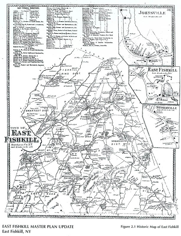 (Then use browser BACK button to return here.)
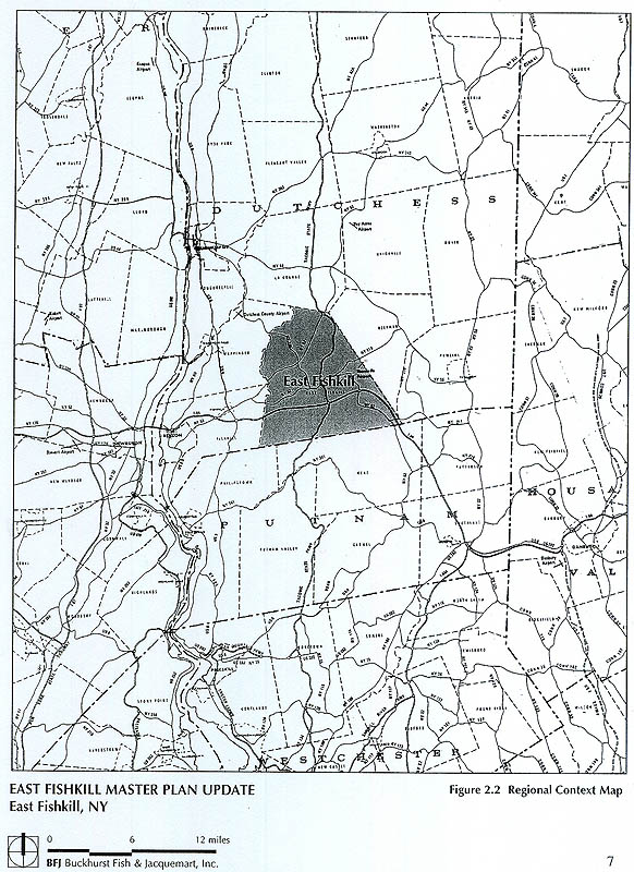 (Then use browser BACK button to return here.)
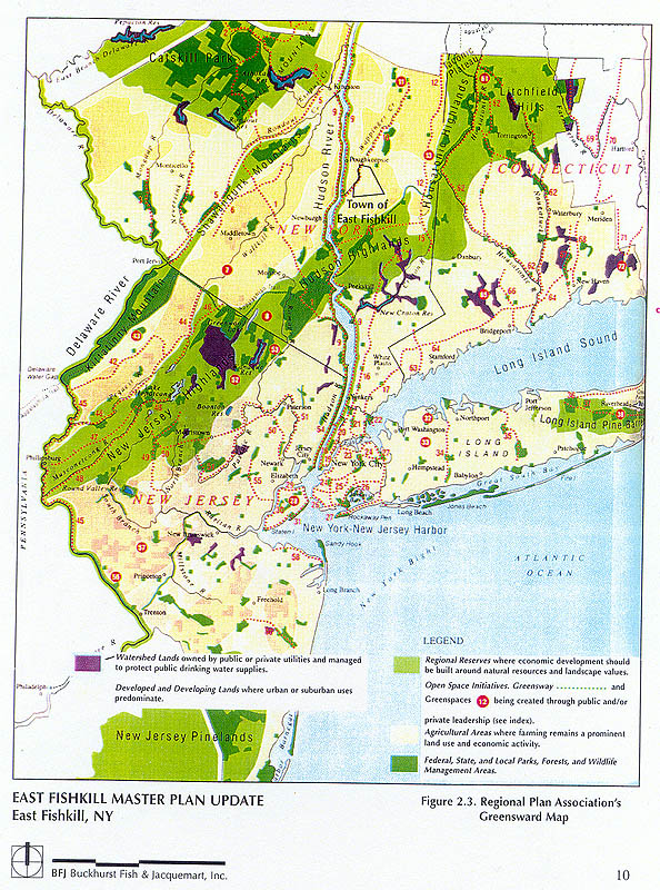 (Then use browser BACK button to return here.)
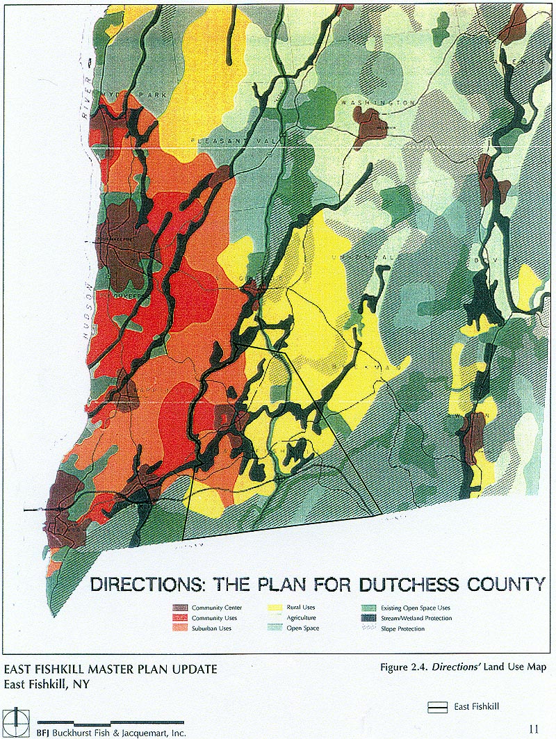 (Then use browser BACK button to return here.)
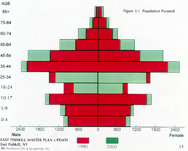 (Then use browser BACK button to return here.)
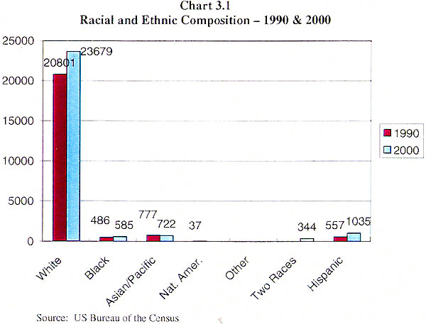 (Then use browser BACK button to return here.)
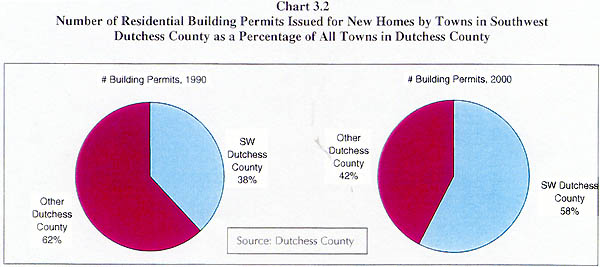 (Then use browser BACK button to return here.)
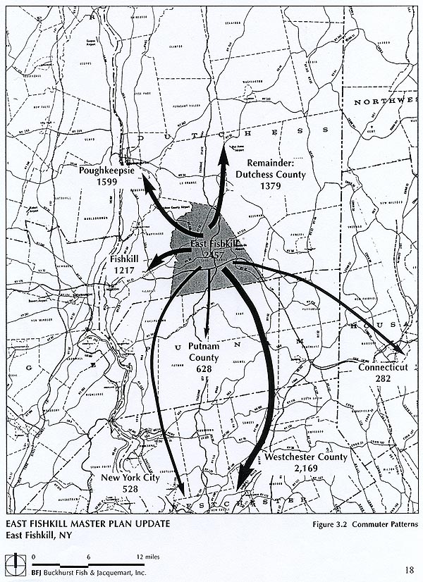 (Then use browser BACK button to return here.)
 (Then use browser BACK button to return here.)
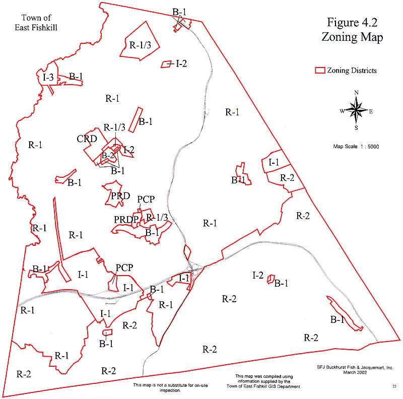 (Then use browser BACK button to return here.)
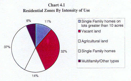 (Then use browser BACK button to return here.)
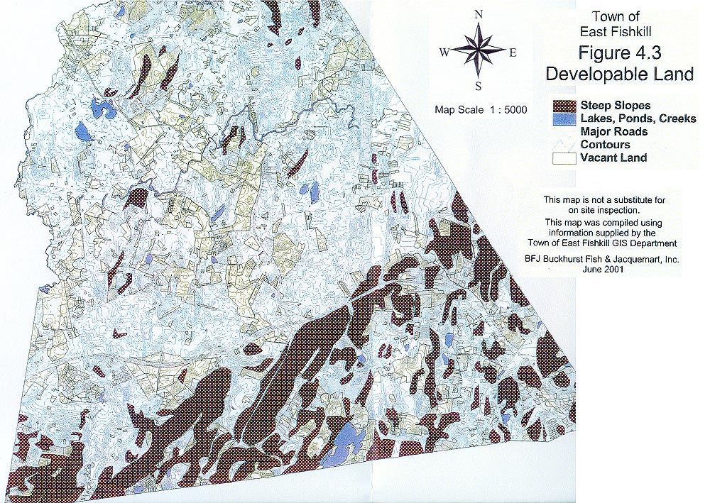 (Then use browser BACK button to return here.)
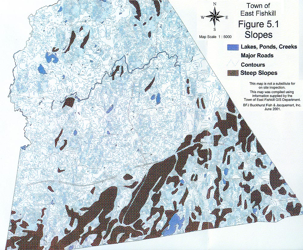 (Then use browser BACK button to return here.)
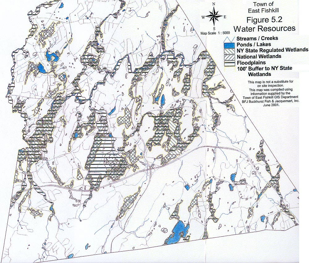 (Then use browser BACK button to return here.)
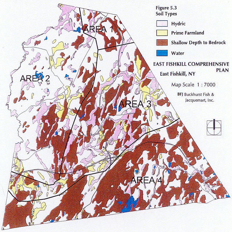 (Then use browser BACK button to return here.)
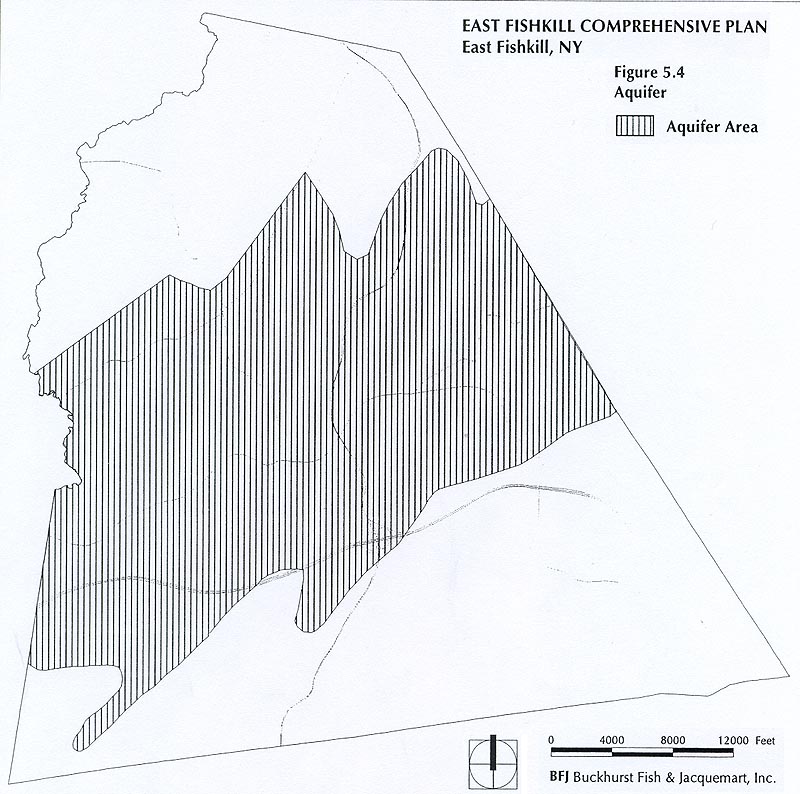 (Then use browser BACK button to return here.)
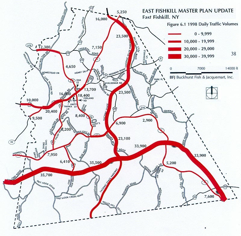 (Then use browser BACK button to return here.)
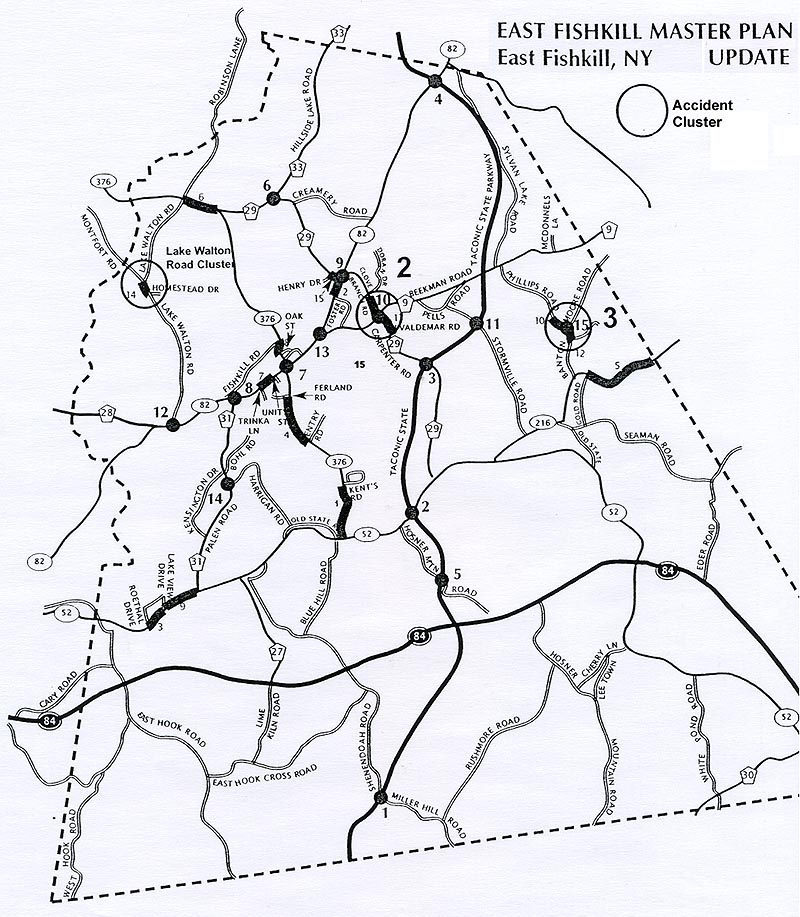 (Then use browser BACK button to return here.)
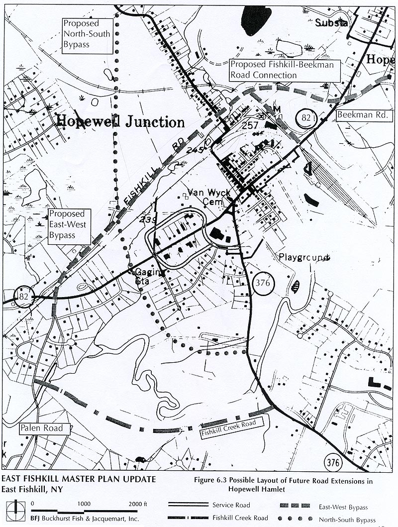 (Then use browser BACK button to return here.)
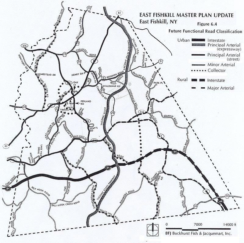 (Then use browser BACK button to return here.)
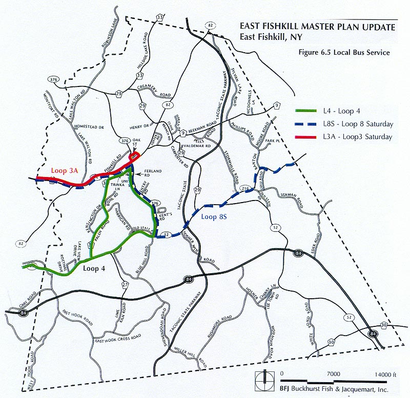 (Then use browser BACK button to return here.)
 (Then use browser BACK button to return here.)
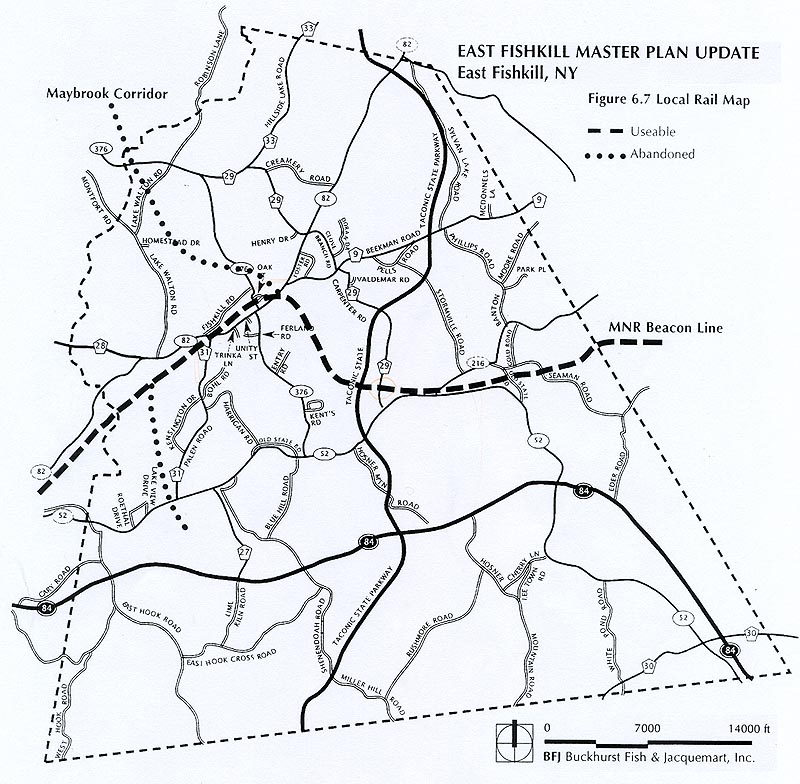 (Then use browser BACK button to return here.)
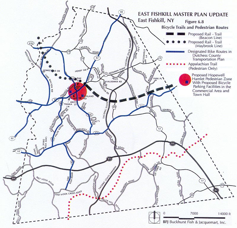 (Then use browser BACK button to return here.)
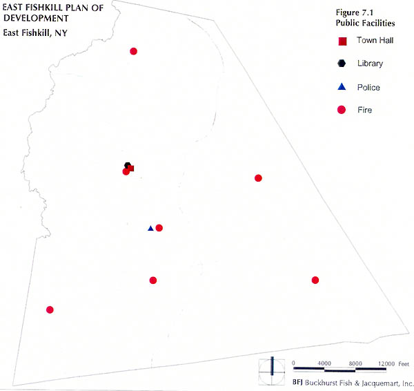 (Then use browser BACK button to return here.)
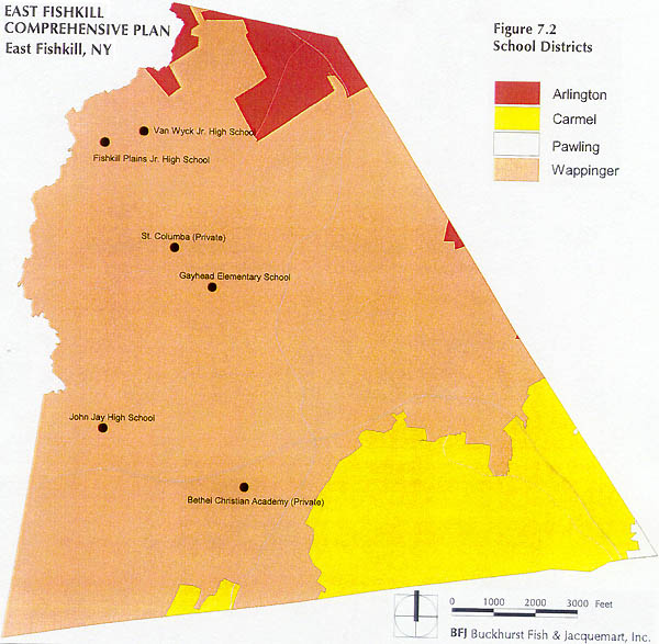 (Then use browser BACK button to return here.)
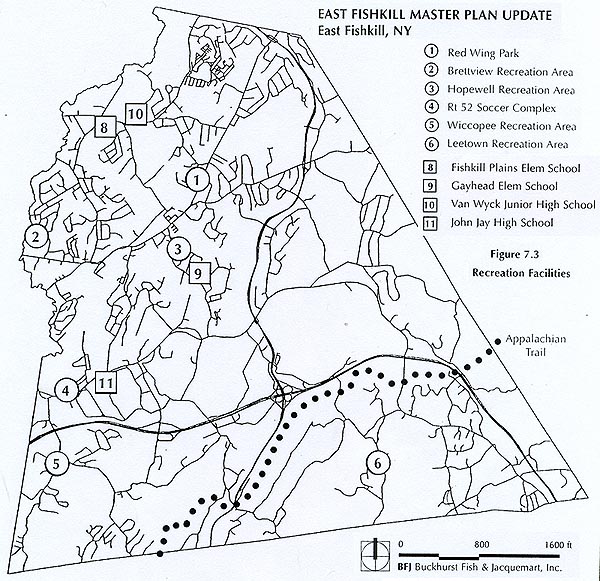 (Then use browser BACK button to return here.)
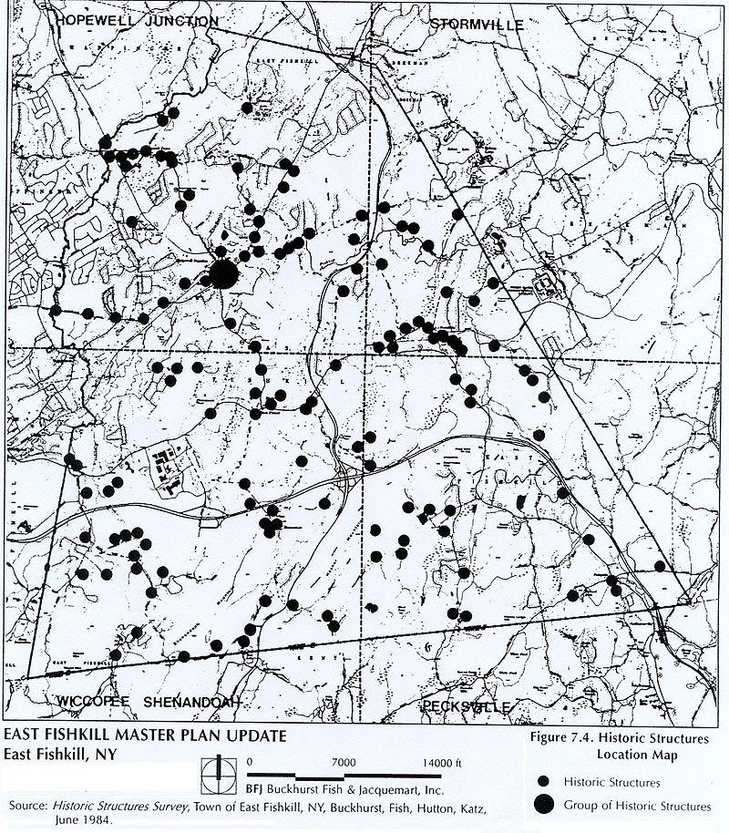 (Then use browser BACK button to return here.)
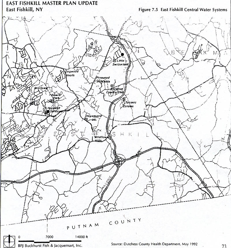 (Then use browser BACK button to return here.)
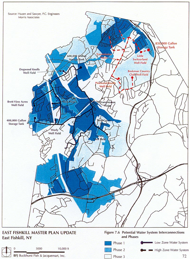 (Then use browser BACK button to return here.)
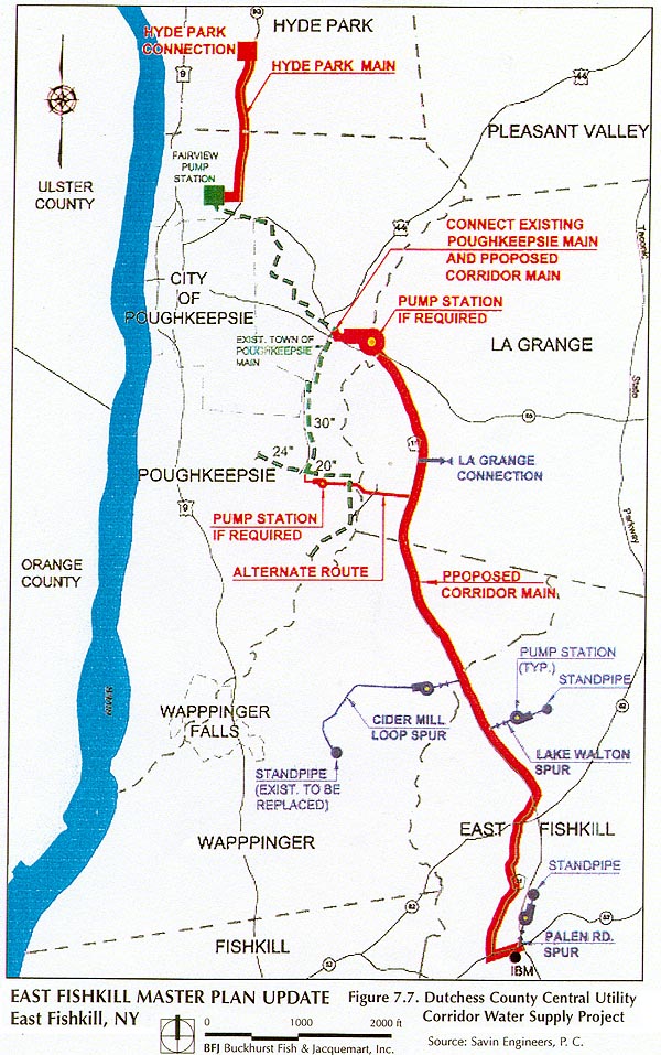 (Then use browser BACK button to return here.)
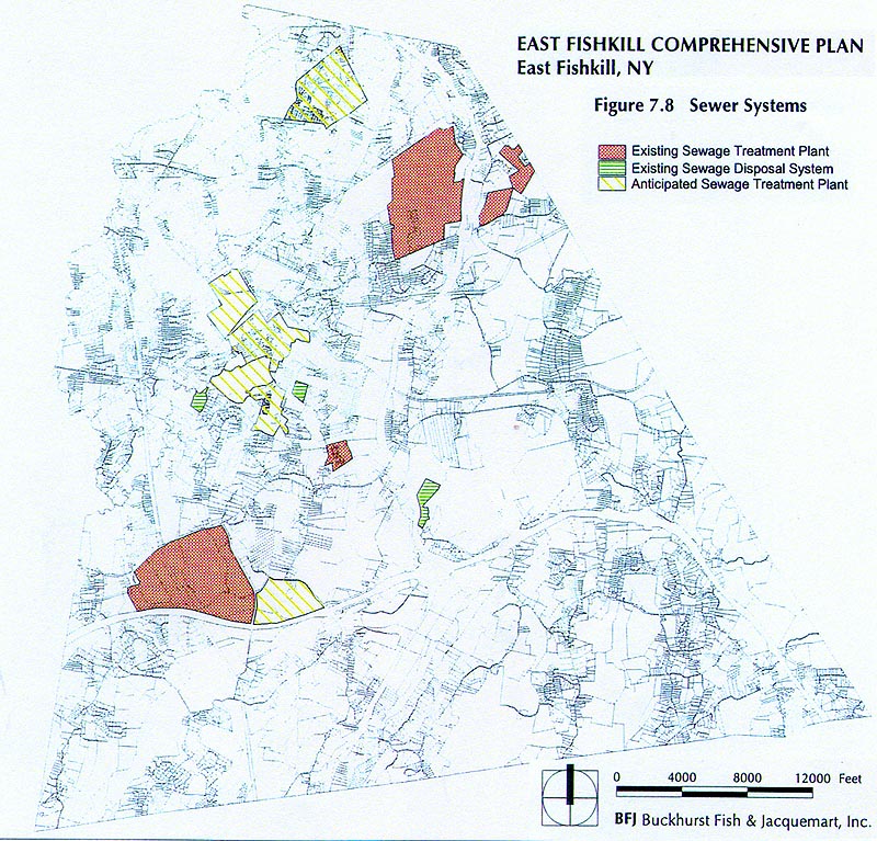 (Then use browser BACK button to return here.)
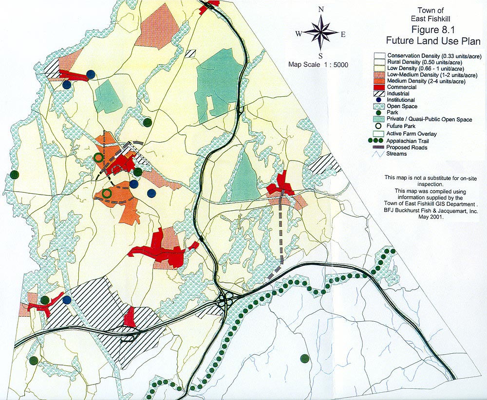 (Then use browser BACK button to return here.)
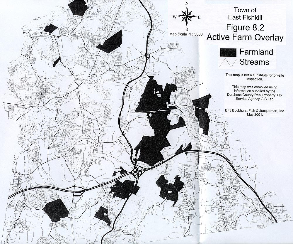 (Then use browser BACK button to return here.)
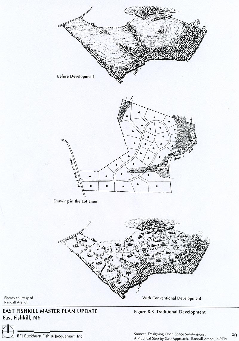 (Then use browser BACK button to return here.)
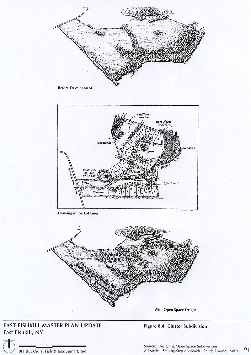 (Then use browser BACK button to return here.)
 (Then use browser BACK button to return here.)
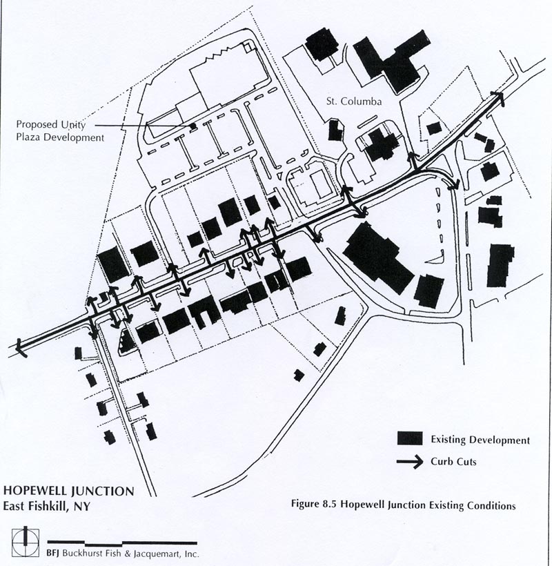 (Then use browser BACK button to return here.)
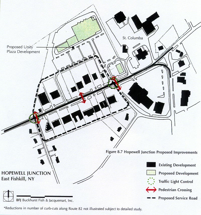 (Then use browser BACK button to return here.)
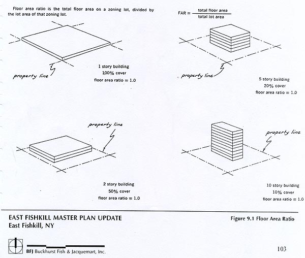 (Then use browser BACK button to return here.)