
Fishkill Creek Stream Walk 2004 - Executive Summary
Sixteen stream segments, or approximately 16 miles, were studied along the main stem of the Fishkill Creek. Fifty-five impaired sites were surveyed, with a total of 104 impairments. Over 700 digital photographs were taken of the stream and surrounding areas, and over 90 global positioning system (GPS) coordinates were taken of features of interest including bridges, dams, outlet pipes, areas of erosion, etc. The participating volunteers donated 477 hours of their time to complete the project.
The main stem of the Fishkill Creek was subdivided into 26 segments, from FC-01 (near the confluence with the Hudson River), to FC-26 (near the headwaters). Ideally, each segment was one-mile long and had a recognizable landmark at each end. Since landmarks are not spaced equally, the actual segments varied from about half a mile to one and a half miles in length. In 2004, 16 of the 26 segments were studied. Of the segments studied, none received a score of excellent, seven received a score of good, four received a score of fair and five received a score of poor. When these scores were considered geographically, a clear trend became apparent. The downstream portion of the creek rated low and the upstream portions rated much higher. All of the segments that rated as poor were located in the lower portion of the creek in the Town of Fishkill and City of Beacon. In the upper portion of the creek in the Towns of Unionvale and Beekman, all of the segments rated as good.
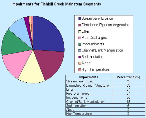
On average, there are 3.4 impaired sites per mile studied, and many of these sites had more than one impairment. The most common impairment observed was streambank erosion, which was present at 49% of all impaired sites. The second most common impairment was diminished riparian vegetation, which occurred at 44% of impaired sites. Both litter and pipe discharges occurred at 27% of impaired sites. The term litter implies significant piles of trash or large manmade objects, such as shopping carts, lawn tractors, washing machines, etc. Impoundments, including dams, occurred at 25% of impaired sites. Channel or bank manipulation occurred at 18% of impaired sites. Finally, both excess algae and high water temperatures occurred at 2% of the impaired sites.
Some types of impairments displayed geographic trends. For example, extensive litter was fairly common in the lower portion of the creek, but uncommon in the middle and upper reaches. Diminished riparian vegetation was uncommon in the lower Fishkill Creek, but commonplace in the middle and upper portions of the creek. Streambank erosion was most abundant in the middle portions of the creek in the Town of East Fishkill. Impoundments were uncommon in the middle portion, but common in the lower and upper sections of the creek.
Other information recorded during the streamwalk program included water temperature, pH, stream depth and width, local land uses, water appearance, fish and macroinvertebrate habitats and substrate embeddedness. Impaired site reports included any unusual smells, type of streambank vegetation, stream bottom composition, presence/absence of waterfowl and observed human activates near the creek.
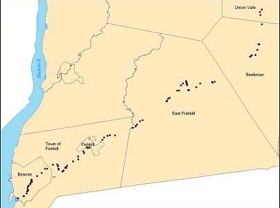
Impaired Sites in the Fishkill Creek main stem identified by Streamwalk 2004.
For complete results, click here.
For more information click here to contact us.